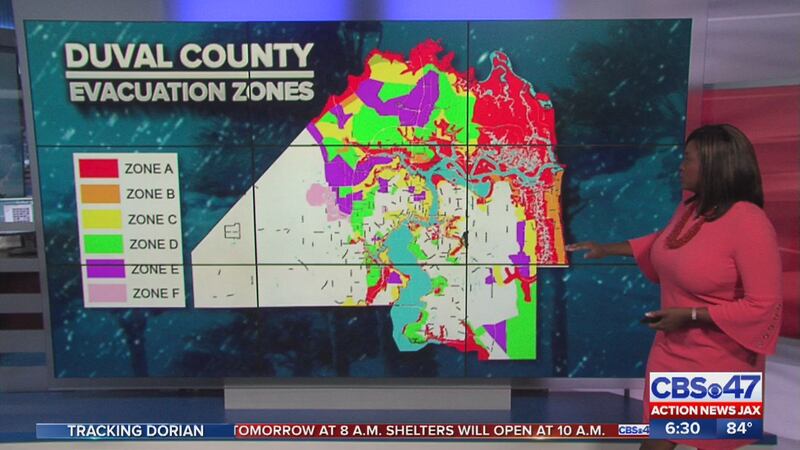
Mandatory evacuation orders have been issued for Duval, St. Johns, Nassau, Clay and Putnam counties. Use this webpage to find out if you're in an evacuation zone.
Enter your address on this interactive map. Zoom out to see what color zone you are in, and look at your county map (below) as a key to find out what zone correlates with that color.
You can also download the JaxReady app and enable location to find your zone.
Duval County evacuation zone interactive map and information:
Families in zones A and B are under mandatory evacuations as of 8 a.m Monday. You can lookup your zone on jaxready.com (the site was experiencing issues Sunday)
Enter your address to find you evacuation zone at https://t.co/N4CRav1nom. If no zone is listed, it's because you are in one of the areas that is not as susceptible to flooding (denoted in white on the evacuation zones map). pic.twitter.com/yktTLHnXMX
— City of Jacksonville (COJ) (@CityofJax) September 1, 2019
For anyone with special needs who needs assistance evacuating, please make sure you sign up here.
St. Johns County evacuation zones:
Evacuation orders go into effect at 8 a.m. on Monday, Sept. 2 for Evacuation Zones A and B, which includes the entire City of St. Augustine, the City of St. Augustine Beach, and those living on waterfront property or in flood-prone areas.
The county has ordered evacuations for Hastings and Flagler Estates. For evacuation information, including route maps and evacuation zones, please visit https://www.sjcemergencymanagement.com/evacinfo.html.
St. Johns County said Sunday that due to intensified conditions of Hurricane Dorian, the county was issuing mandatory evacuation orders effective at 8 a.m. on Monday for Evacuation Zones A and B https://t.co/Bp0dm5UNAn pic.twitter.com/kv04q8gkPM
— ActionNewsJax (@ActionNewsJax) September 1, 2019
Nassau County evacuation zone map and flooding information:
Mandatory evacuations are in place for families in Zones A, C and F as of 8 a.m. Monday. Look up your zone here.
Nassau County said mandatory evacuations are in place for zones A, C and F as of 8 a.m. Monday. pic.twitter.com/vh0G4FJten
— ActionNewsJax (@ActionNewsJax) September 1, 2019
Putnam County has issued a mandatory evacuation effective Monday for Evacuation Zone A, people in low lying areas living in boats, recreational vehicles and mobile homes. Look up your evacuation zone here.
Clay County has issued mandatory evacuations for zones A, B, low-lying areas and vulnerable homes effective Tuesday at 3 p.m. Click here to look up evacuation zones.
Bradford County evacuation map.
Camden County evacuation routes, maps and information.
Baker County evacuation route map.
Columbia County evacuation route map.
Glynn County evacuation routes and zones.
General Georgia Department of Transportation evacuation map.
General Georgia evacuation zones information.
Enter your address to find you evacuation zone at https://t.co/N4CRav1nom. If no zone is listed, it's because you are in one of the areas that is not as susceptible to flooding (denoted in white on the evacuation zones map). pic.twitter.com/yktTLHnXMX
— City of Jacksonville (COJ) (@CityofJax) September 1, 2019
RELATED: Live updates: Hurricane Dorian’s track shifts east Hurricane supplies: Here’s what you need ahead of Dorian Sandbag locations: Here’s where you can get sandbags ahead of Dorian EVACUATIONS: Look up your evacuation zone here SCHOOL CLOSURES: Duval, Nassau, other local counties cancel school
Cox Media Group


