The Action News Jax First Alert Weather Team has declared a First Alert Weather Day due to heavy rain and thunderstorms in our area.
This alert is in effect for Northeast Florida and Southeast Georgia until later tonight.
WATCH THE FORECAST | DOWNLOAD THE APPS
Notes from The First Alert Weather Team:
- Pre-sunrise conditions are mild with a few showers in SE GA and a few storms approaching our southwestern counties from the Tampa Bay region.
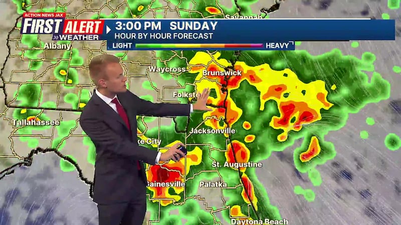
- Shower and storm activity will gradually increase in coverage and intensity across our local area throughout the day.
- By the early afternoon, fairly widespread coverage of rain is expected, with some embedded thunderstorms.
- Storms will produce very heavy rain today (beneficial for pollen and brushfire risk), but could cause some localized flooding in typical spots.
- Average rain amounts of 1-2″ are expected today.
- An isolated strong or severe storm can’t be ruled out today, but overall, the threat of significant severe weather is low.
- Rain will taper off after sunset and we will stay mild tonight.
- Another threat for storms arrives late Monday with a cold front approaching the area. The storms ahead of this front will be weakening as they cross through our local region, but a few storms may be severe, particularly across SE GA. Much of the day Monday will be dry and very warm.
- Near record-high temperatures will carry us through the remainder of the week.
Follow Action News Jax Meteorologists on Twitter for updates:
Mike Buresh | Garrett Bedenbaugh | Corey Simma | Trevor Gibbs
7-day Forecast:
- TODAY: First Alert Weather Day. Showers and thunderstorms. HIGH: 80
- TONIGHT: Rain ending early, staying mild. LOW: 65
- MONDAY: Partly cloudy and very warm. A Few PM Showers/Storms, more in SE GA. 65/88 (Record: 90 - 2021)
- TUESDAY: Partly cloudy, isolated shower. 62/85
- WEDNESDAY: Partly cloudy, isolated shower. 63/88 (Record: 90 - 2012)
- THURSDAY: Partly cloudy and very warm. 67/88 (Record: 89 - 2017)
- FRIDAY: Mostly sunny. 66/87 (Record: 90 - 2011)
- SATURDAY: Partly sunny. 65/88 (Record: 91 - 2017)
ALLERGY TRACKER: See what the pollen counts look like in our area
LISTEN: Mike Buresh ‘All the Weather, All the Time’ Podcast
INTERACTIVE RADAR: Keep track of the rain as it moves through your neighborhood
SHARE WITH US: Send us photos of the weather you’re seeing in your area ⬇️