JACKSONVILLE, Fla. — Updated every day during the hurricane season: “Talking the Tropics With Mike”.

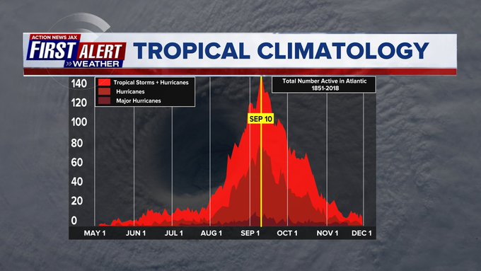
Leading into Labor Day weekend all eyes are on the tropics - might Cat. 4 “Franklin” over the Western Atlantic that will thankfully stay over the Atlantic... & Idalia which developed over the Northwest Caribbean before moving north/northeast. We’re nearing the peak of the Atlantic hurricane season - Sept. 10th - not to mention about 1 out every two years there is a named storm over the Atlantic Basin on Labor Day.
A track such as Idalia’s - to the northeast from the Yucatan Channel to the Florida Big Bend while intensifying all the way up to landfall - is not a common type tropical cyclone but has happened before & proved to be very damaging - the “Cedar Keys Hurricane”. There was no proper name assigned to the storm because the NHC naming convention did not begin until the early 1950s.
From Jax N.W.S. meteorologist Al Sandrik & Chris Landsea, National Hurricane Center in their reanalysis project for tropical cyclone events:
Year: 1896
Date(s): 29 September
Principle Affected Area(s): Northeast Florida - major hurricane
Upper Georgia - hurricane
Lower Georgia - hurricane
Interior North Florida - major hurricane
Northeast Florida coastal waters - hurricane
Upper Georgia coastal waters - hurricane
Lower Georgia coastal waters - hurricane
Landfall Point(s): Overland from Cedar Key
Remarks: Partagas and Diaz Storm 4, 1896, listed by Davis. Dunn and Miller identify as a major hurricane with 100 killed , but Ho does not reevaluate this event.
This accelerating and very asymmetrical storm moved inland north of Cedar Key and progressed northward across Lake City, Fl. and Jesup, Ga. The storm was moving rapidly ahead of a large Polar air outbreak and has already been identified as major in the southeast Gulf of Mexico. Period reports indicate this was a major event over land also. After the eye passed over Lake City the winds there were estimated to be 150 mph , although that value must be used with extreme caution. Tremendous destruction occurred in a 50 mile wide swath from Cedar Key to Savannah, with most of the damage occurring east of the center. The center appears to have made landfall near the mouth of the Suwannee River between 6 and 6:30 AM (Partagas brings the center onshore to early) and passed across Fort White at 7:30 AM and Lake City around 8 AM . The center was later identified at Guyton, Ga, west of Savannah, between 12:30 and 12:45 PM. This is an approximate track distance of 215 statute miles and estimating a 7 hour transit time yields a forward motion slightly in excess of 30 mph.
Maximum wind speeds at downtown Jacksonville were southeast at 70 mph (60 statute miles east of the storm center). Period accounts of the 2 October 1898 hurricane indicate the 1896 hurricane had a higher wind velocity at Darien, along the Georgia coast. Based on a best fit hurricane using the SLOSH model, a central pressure of 960 mb with a 15 nm Radius of Maximum Wind is indicated at landfall. This central pressure suggest a 115 mph from the Gulf of Mexico wind-pressure relationship (Landsea et. al. 2002). With a smaller than usual RMW for this central pressure and latitude and a rapid forward motion (30-35 mph at landfall), winds are estimated at 125 mph at landfall. landfall. A 963 mb central pressure estimated via Ho’s methodology for 12Z on the 29th suggests 106 mph from the subtropical wind-pressure relationship
- 115 mph chosen due to small RMW and fast speed of motion although the hurricane is overland. Period reports of damage to structures and forested areas are consistent with this estimate, suggesting this was a major hurricane inland over northeast florida. Surface analysis suggest an outer pressure of 1014 to 1016 mb would be appropriate for this event.
Summary: This storm will be counted as a major hurricane for interior north Florida and northeast Florida and a hurricane for all of the coastal waters areas.
The “Monthly Weather Review” has an interesting read to * here *.