JACKSONVILLE, Fla. — First Alert Neighborhood Weather Network. Scan below &/or click * here *:

“Talking the Tropics With Mike” is updated every day during the hurricane season (through Nov. 30th) * here *

Helene is going down as the storm from hell for multiple reasons:
* the hurricane was difficult to pin down a week in advance though the forecast quickly came into view over the next few days with a clear indication by Sunday (4 days beforehand) that a hurricane would be over the Gulf of Mexico & likely headed for Central & Eastern Gulf or Florida
* the Big Bend landfall is the third landfall for roughly the same area in 13 months (Idalia, Debby & Helene)
* the fast moving Cat. 4 hurricane reached its peak upon approach to landfall
* the fast, intense hurricane caused considerable damage well inland.
* Helene dumped very heavy rain in a short period of time while slowing down over - in particular - Northern Ga., the Southern Appalachians including the Western Carolina’s, Western Virginia & the eastern half of Tennessee.
The image below is from early in the week as Helene was just taking shape. Very warm ocean water to a great depth extends from the Caribbean then north in a “nose” up the Eastern Gulf. Shear increased with northern extent but was likely less hostile for Helene because the hurricane was moving in the same direction as the shear vectors & was also likely offset by good upper level ‘ventilation’ due to the proximity of a trough to the immediate north (which was pulling Helene N/NE):

Below is the 500mb GFS forecast for Thu., 09/26 - day of landfall. The interaction with the trough to the north & northwest was key in Helene’s northward movement then stall over the Tennessee Valley once captured by what became a cut-off upper low.

First & foremost, I should emphasize Jacksonville did not get hit by a hurricane (like Matthew, Irma, Ian & Nicole - close calls but not an eye of a hurricane crossing over Duval Co.
I’ll begin with the forecast. I raised a red flag about Gulf development Sept. 17th - a week before Helene was upgraded in “Talking the Tropics With Mike”. At 9am Sun., Sept. 22 I sent the following email to our newsroom managers & First Alert meteorologists:
“The tropics will be the story for at least the next 5 days. Check & re-check the First Alert Forecast.
The timeline has bumped up (earlier) a bit - by roughly 24 hours vs. this past Fri. with a possible landfall in Fl. or along the Central & Eastern Gulf Coast Thu.
*At this time* it would appear relatively minor impacts for Jax... more for Waycross/Lake City but subject to change, of course.”
I received at least one comment on social media saying I was “teasing folks to come back & watch to get more info.” when I posted the graphic below one week before landfall on Thu., Sept. 19th. While confidence was high that a tropical cyclone was going to develop, I was not yet confident on intensity & especially location. Until I felt reasonably confident about impacts, I stuck to what I thought was most responsible - a heads-up, “always be prepared” approach.

Over the weekend, confidence increased a good deal on especially a potentially powerful system. On Mon., Sept. 23 the First Alert Weather team socialed & put on t.v. this graphic:

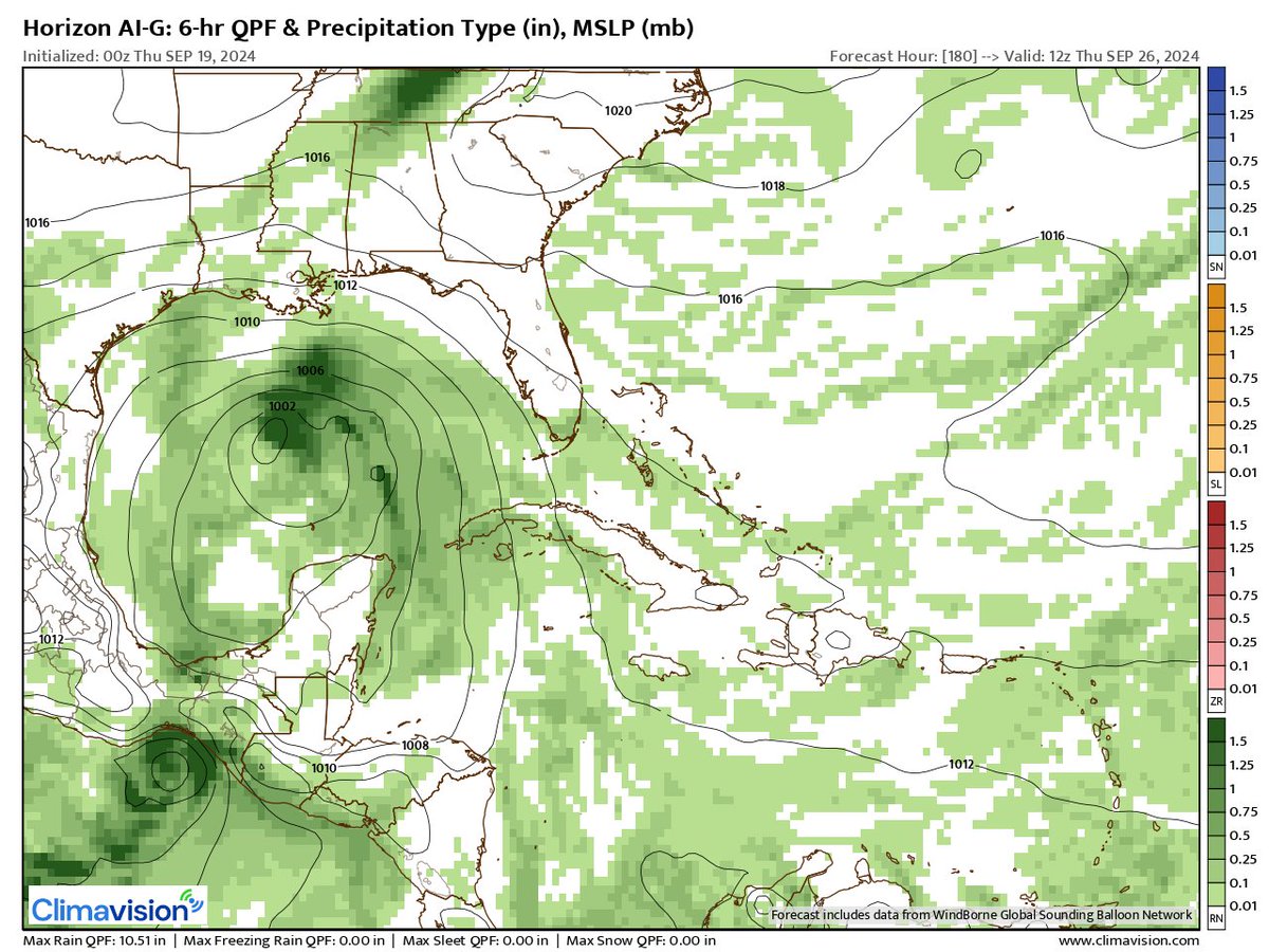
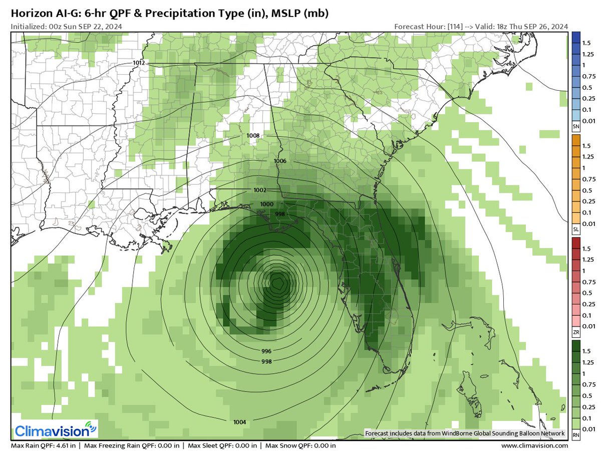
As for the models... early on - the week before - the GFS American model was pretty good at insisting on tropical development but was quite varied on intensity & location... the European model was way west & much weaker showing a system over the far Western Gulf... the Canadian model was generally in-between. The First Alert weather team has exclusive access to Climavision ‘HorizonAI’ global model which uses its own data & analysis for initialization of each model run + some AI input. The Horizon model had great consistency on insisting on tropical development while varying on location & intensity before becoming insistent on & converging on a Florida then Big Bend landfall. The first map below is from Wed., Sep. 18th valid early Thu., Sept. 26th which ended up being landfall “day”. Cleary to weak, too slow & too far west. The second map is 2 days later & the ‘Horizon’ is stronger but still much too slow, too far west valid for early Fri., the 27th. The third map was 24 hours later valid at 2pm Thu., the 26th - stronger, farther east & faster. The fourth map was 2 days later from very early Tue., Sept. 24th or nearly 72 hours before landfall valid at 8pm Thu., Sept. 26th showing a hurricane just inland of the Big Bend - pretty close to reality but a bit fast. The ‘Horizon’ did a pretty good job after landfall showing more - though still not quite enough - northeast movement into Ga. before the turn more north which was critical for the high wind forecast from Lake City to Waycross, Blackshear & Folkston, Ga.


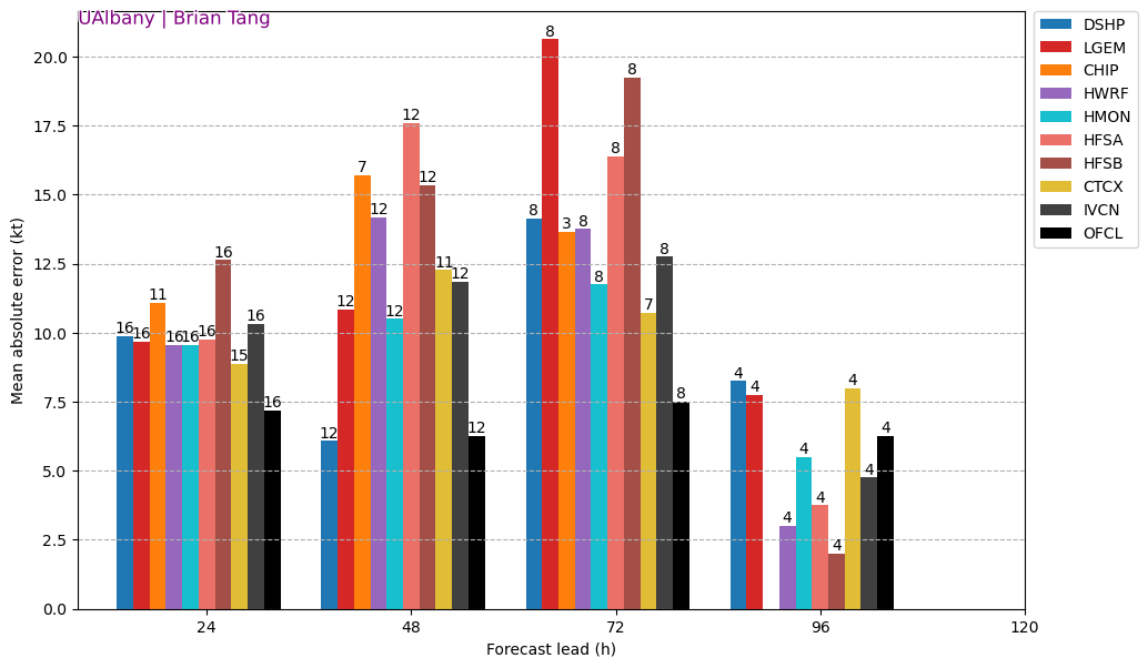
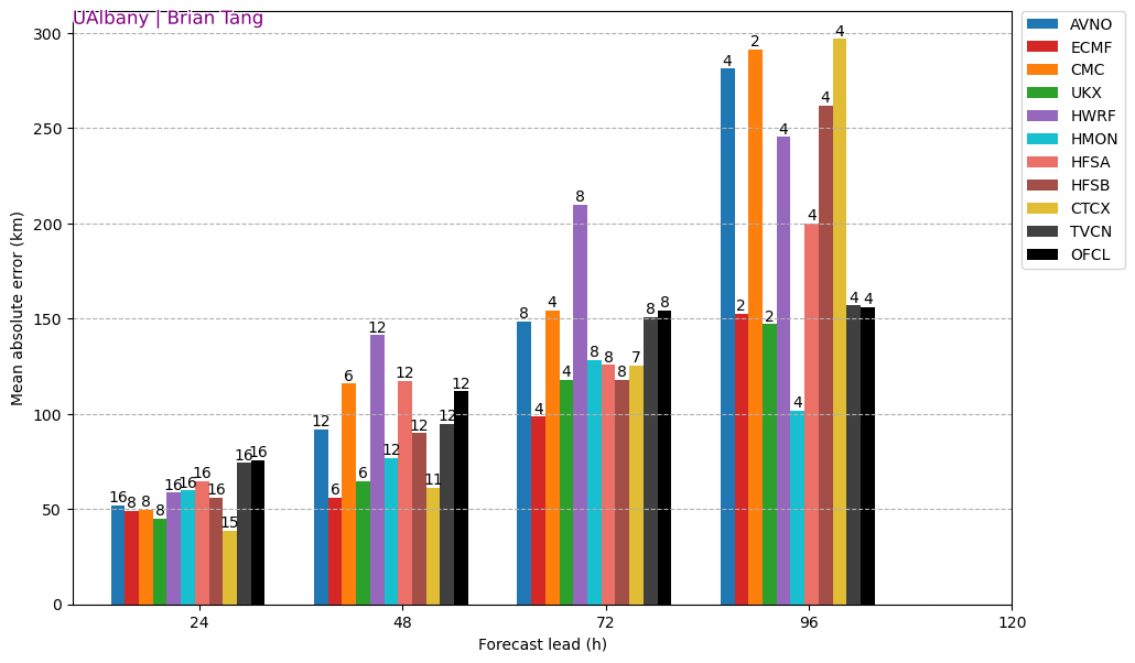
The two images (graphs) below are from the University of Albany & show model forecasts & the avg. error in wind speeds (knots) vs. location (kilometers). The National Hurricane Center (OFCL) forecast on intensity was quite good & generally outperformed the models through 72 hours (3 days in advance). The location proved more difficult for NHC (OFCL) but was still very good though generally a bit too far west vs. actual landfall. The European model was good on location up to 4 days out but recall the model was way too far west & weak at 5 days & beyond.
Models & forecasters did a good job of capturing Helene’s potential for rapid intensification (RI) though it took a little longer to be realized. As I posted in the “Talking the Tropics With Mike” early in the week:
“It’s also interesting to note the rapid strengthening of hurricane “John” over the far East Pacific that moved inland on the west (Pacific side) coast of Mexico Mon. night/early Tue. There may be some symmetry with the Gulf system as upward vertical velocities that aided John spread eastward to the Atlantic Basin.”
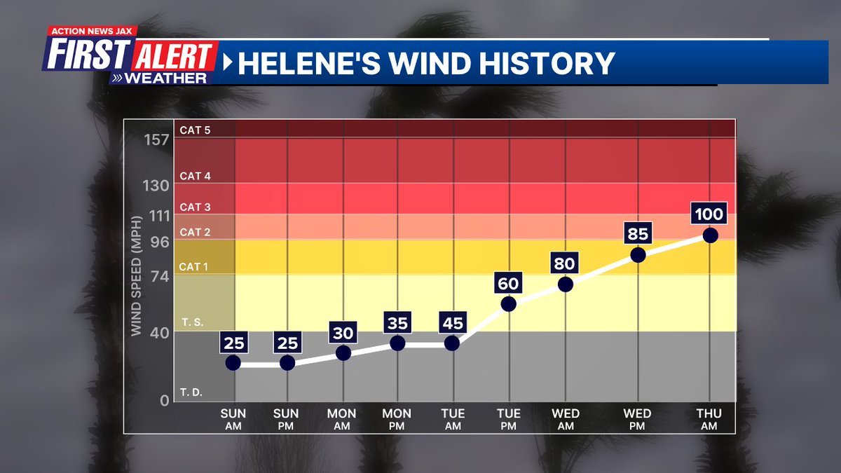
Helene’s primary (the most rapid) RI occurred from midday Thu. through Thu. evening which intensification was more steady from Monday through Wed.:
Early Tue. morning - more than 2 1/2 days prior to landfall - I wrote the following in “Talking the Tropics With Mike”:
“Tropics threats for Jacksonville/NE Florida/SE Georgia: None through Tue. into Wed. Given *current forecasts*, heavy rain, isolated tornadoes/waterspouts, gusty winds & rip currents at area beaches will be a growing threat for NE Fl./SE Ga. Wed. night through Thu. into early Fri. due to landfalling Helene a couple hundred miles west of Jacksonville. How significant these impacts are will depend on the exact track & strength of Helene. Right now - the I-75 corridor will have the highest winds in N. Central Florida.
All areas from Mississippi to Florida need to stay up to date on the latest forecasts for mid to late parts of the upcoming week. Those in the Fl. Panhandle & west coast of Florida should be well underway with hurricane preps. The peak time for impacts will be Thu.-Thu. night for Florida... Friday for Georgia & parts of the Carolina’s... even as far north as Tennessee.”
I expected - & indeed started to receive feedback - that the “skinny cone is far from Jacksonville so there won’t be any impacts”. We made a concerted effort on air, online & in social media to show graphics similar to below indicating the width of the wind field vs. the cone. It was a large “wing span”!

Our (First Alert Weather team) wind forecast was pretty decent. And while I expected more trees to fall than might typically occur with such wind speeds because of all the September rain in the previous weeks, the magnitude of power outages for Duval Co. was surprisingly high to me - 113,000 Duval customers were without power early Fri. morning, 09/27. For context 280,000 customers were without power after “Irma” in 2017 & 250,000 customers were in the dark after “Matthew” in 2016. But JEA was quick to restore power with all but 1% of customers with full electricity by Sunday morning just about 48 hours after the highest winds. Full restoration took more than a week following both Matthew & Irma.
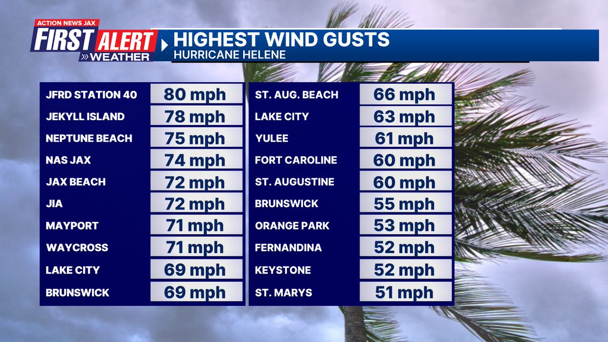
The First Alert wind forecast below vs. reality (2nd image):

The map below was a new one employed by the First Alert Weather Center & was the “brain child” of Trevor Gibbs dividing the area into impacts ‘manageable’ vs. ‘high’ vs. ‘extreme’ + the river flooding on the St. Johns River. I was most concerned about high tide Thu. evening when strong south winds would be roaring north to the east of Helene’s center sending water up & over the Northbank into parts of downtown Jacksonville, especially Riverside. I did not forecast levels to be as high as during Matthew & especially Irma (more similar to Nicole in Nov., 2022) - the ‘moderate’ level of a little over 2 feet Thu. evening which proved to be very accurate & no river water reached into homes (record is an estimated 6 feet in 1846... Irma’s flood stage was 4.41 feet.

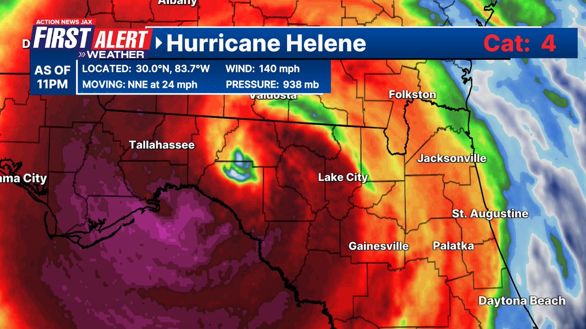
I bracketed 9pm Thu. to 3am Fri. as the most severe wind impacts for NE Fl/SE Ga. with strong winds continuing through at least sunrise:
#HurricaneHelene goes Cat. 4 - rapid intensification cycle -Big Bend landfall just hours away (~10pm-midnight +/`) @actionnewsjax @wokvnews - strongest Jax/NE Fl./SE Ga. impacts 9pm Thu.-3am Fri. though strong winds continue into Fri. morning #FirstAlertWx pic.twitter.com/AJZJ4IH1NI
— Mike Buresh (@MikeFirstAlert) September 26, 2024

The eyewall of Helene became very “electrical” - full of lightning - during the rapid intensification cycle in the afternoon & evening:
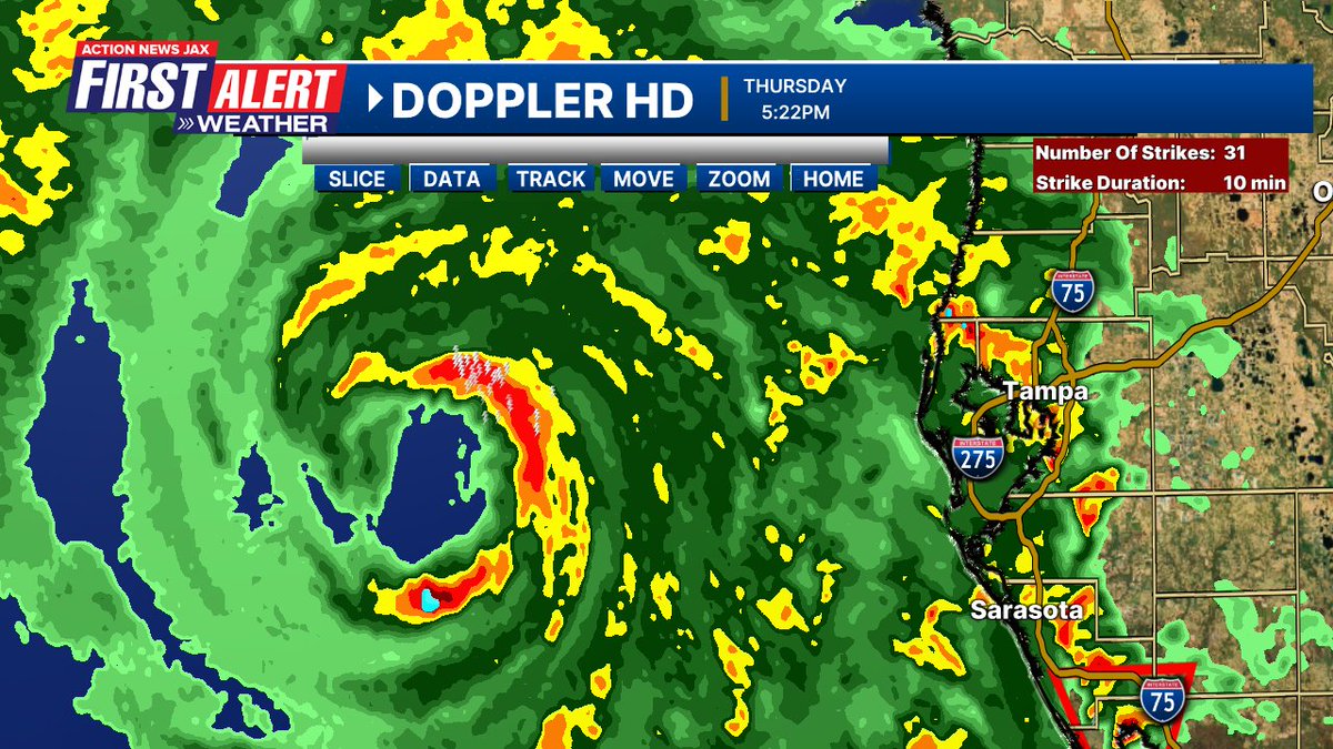
An interesting metamorphosis of Helene’s eye occurred upon approach to the Big Bend not long before landfall. The eye became “squished” & more horizontal vs. the clear doughnut that became established over the Eastern Gulf during the RI phase & that is common with mature, intense hurricanes. It looks like this change in the structure of the eye was caused by friction of land interaction with the upside down ‘U’ shape of the Big Bend. The large counterclockwise circulation of Helene meant the eastern & northern quadrants were feeling of the effects of land interaction - particularly the eastern half of the circulation - well before the eye was making contact with land. This is one of the reasons the Big Bend of Florida has always been *somewhat* protected by intense hurricanes. It’s not easy for a hurricane to make a direct hit on the Big Bend without weakening first. Helene was a different “beast” & made landfall at its peak. The Big Bend topography tried to naturally protect like it has for so many years but Helene was not be deterred. Hence, the most powerful hurricane to ever make landfall in the Big Bend.

#Helene was the fourth hurricane landfall in the United States this year. Widespread impact well inland and away from the storm center. @actionnewsjax #firstalertwx Extended radar loop: pic.twitter.com/M5s26iGKwl
— Trevor Gibbs (@TrevorsWeather) September 28, 2024
From tropical disturbance to a devastating Category 4 hurricane in two and a half days.
— CIRA (@CIRA_CSU) September 27, 2024
Hurricane Helene's incredible evolution from the Caribbean Sea to Florida coastline. pic.twitter.com/GMn8BLQmr4
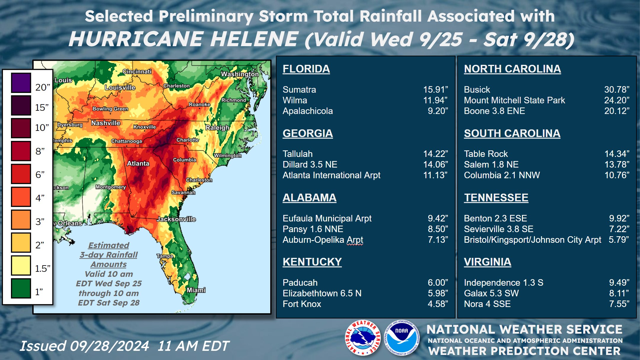
Our rainfall forecast for Jacksonville/NE Fl./SE Ga. was relatively insignificant considering a tropical cyclone, but the forecast landfall point + especially the fast movement implied lower amounts which indeed were realized. For many areas east of Highway 301 to the coast, amounts were less than an inch. Much heavier rain fell from the Panhandle & Fl. west coast northward through Ga, the Carolina’s, Virginia, Kentucky & Tennessee:
Before & after satellite view not from Perry, Fl. near landfall:
‼️ Before and After of Gulfview Road in Perry, Florida. Storm surge swept homes away. #Helene #FLwx 1/ pic.twitter.com/jDbwtwpdKN
— Chris Gloninger, CCM, CBM (@ChrisGloninger) September 28, 2024
Much of N. Central Fl. & inland Ga. suffered much longer lasting effects due to the magnitude of winds. In Waycross, Ga. there were long lines at gas stations:

Power outages across several states in the southeast US outline the path Hurricane Helene took as it traversed inland. pic.twitter.com/WRZjOJtALl
— CIRA (@CIRA_CSU) September 30, 2024
Florida landfalling Cat. 3+ hurricanes since 2014:

Jacksonville N.W.S. Helene summary * here *.
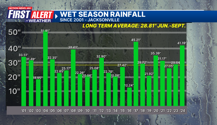
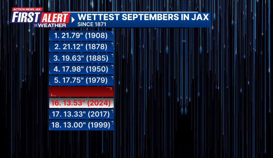
So our wet season - by definition - June through September has come to an end. After a very sluggish start & unseasonably “dry” June, July/Aug. & especially Sept. more than made up for it. Sept. was the 16th wettest on record for Jacksonville but at about 13.5″ was far behind a number of spots near/east of I-95 that measured as much as 18-25″ for the month! The 41.19″ officially at JIA is still more than a foot above the avg. wet season. Other notable years (the only wetter years than ‘24 this century) were ‘04 (Bonnie, Frances, Jeanne impacted the local area) & ‘17 (Irma in Sept.).
The combination of July/August & September was the wettest on record in Jacksonville & each month with more than 10″ of rain is a first for any 3 month period in Jacksonville.

For the year... if JIA had no more rain at all the rest of the year, Jacksonville would still end up 5″ above avg.(!).

So the Jacksonville (JIA) averages for October: