JACKSONVILLE, Fla. — The “Buresh Blog” will try to enjoy some R & R next week & will be updated again the week of Oct. 28th.
First Alert Neighborhood Weather Network. Scan below &/or click * here *:

“Talking the Tropics With Mike” updated every day during the hurricane season June 1 - Nov. 30.
So... another week, another hurricane hits the U.S.
Hurricane Milton - a name that’s new to the Atlantic list after infamous 2018 “Michael” was retired, will likely be replaced after this year (list of names rotate repeating every 6 years).
The First Alert Weather Team & I had been monitoring the potential for Gulf/Caribbean tropical development for some two weeks prior to development. It was unclear exactly what might unfold, but all the signals indicated a tropical system... that would probably eventually hit the U.S. The genesis on Sat., Oct. 5 appeared to be a combination of a tropical wave moving northwest out of the Caribbean, a stalled front over the Gulf of Mexico & a tropical wave moving north from the Pacific across Central America into the Western Gulf.
There was plenty of advance notice to Florida. My headline on Fri., Oct. 4 - 6 days prior to landfall:
“Slow Gulf development could impact Florida mid next week...”
Thursday (10/03) afternoon I went into our Action News Jax newsroom & spoke with each manager individually “hurricane near Florida by the middle of next week”. And we added to our 7-day forecast graphic “Tracking the Tropics” for Wed.-Thu. I sent the following email to our newsroom Fri. at 8am:
Low pressure will develop over the weekend over the Gulf of Mexico & head east. Still some work to be done on the exact outcome... but it would appear a potential named storm could be approaching west or SW Florida by about Wed. of next week.
Stay up to date for the latest First Alert forecasts....“Talking the Tropics With Mike”.
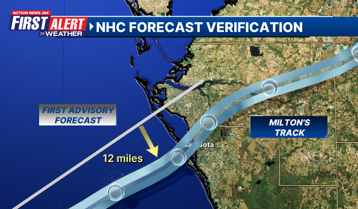
And the National Hurricane Center could hardly have issued a more accurate landfall forecast on their very first advisory Sat., Oct. 5th - nearly 5 days prior to the “hit”.
Hurricane Milton's remarkable evolution across the Gulf of Mexico to the Florida shore. pic.twitter.com/Za0rQ1wDwR
— CIRA (@CIRA_CSU) October 10, 2024
Images & analysis below from Cooperative Institute for Meteorological Satellite Studies (CIMSS) shows plenty of very warm ocean water, lots of mid & upper level moisture but increasing shear:
#firstalertwx considerations for #Milton - very warm water temps... warm deep oceanic heat content with very warm eddy E. Gulf... lots of moisture = favorable for strengthening... shear will increase with eastward extent but will be in line w/ forward movement so less detrimental pic.twitter.com/Ky3FSohWv2
— Mike Buresh (@MikeFirstAlert) October 5, 2024
MODELS:
The global forecast models had a major mix of success & misses on Milton. The image below is from Sat., Oct. 5th showing the 8am forecast for Wed., Oct. 9th. Wednesday did end up being landfall at about 8:30pm EDT. In the end... the American GFS was pretty darn close... the European model was too far south & too weak. The Canadian & UKMET models, by the way - were way too far south, too weak & way slow showing a Friday landfall until late in the “game”. The latter two models ended up being un-useful. The most difficult part of the forecast ended up being the exact track & intensity across Florida.

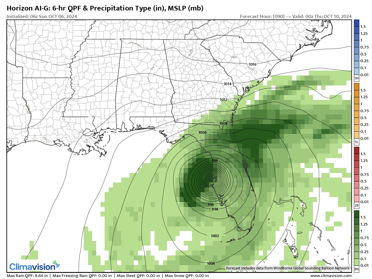
Which takes us to the Climavision ‘HorizonAI’ global model to which the First Alert Weather Team has exclusive access to. Overall - it was pretty darn good. The first image below is from Fri., Oct. 4th valid at 8am Wed., Oct. 9th (keep in mind landfall was Wed. evening). It’s pretty darn close all things considered - a solid 5 1/2 days before landfall which was at 00:30kZ Thu., 10/10:

From early Sat., 10/05 valid at 18Z (2pm) Wed., 10/09 - pretty darn good:

From early Sun., 10/06 valid at 8pm Wed., Oct. 9 which ended up being very close to actual landfall, nearly 4 days in advance:
From 2pm Sun., 10/06 valid at 2am Thu., Oct. 10th - a bit too slow but otherwise pretty darn close:

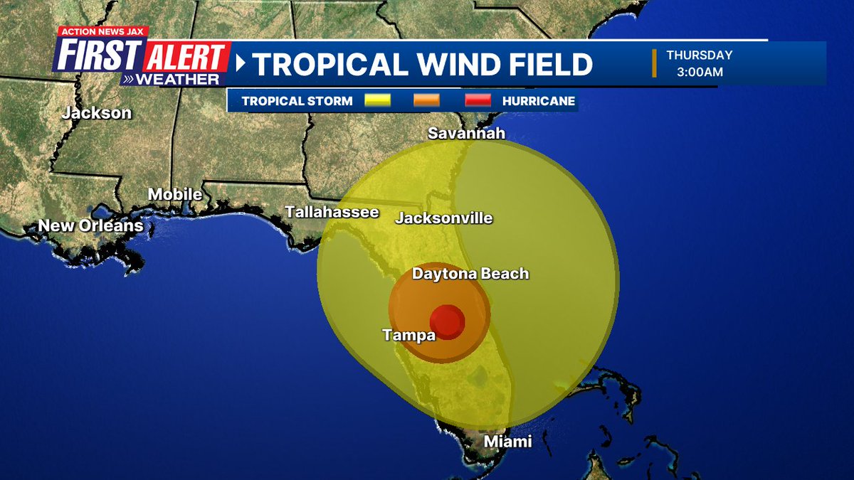
MILTON’S TRACK & INTENSITY:
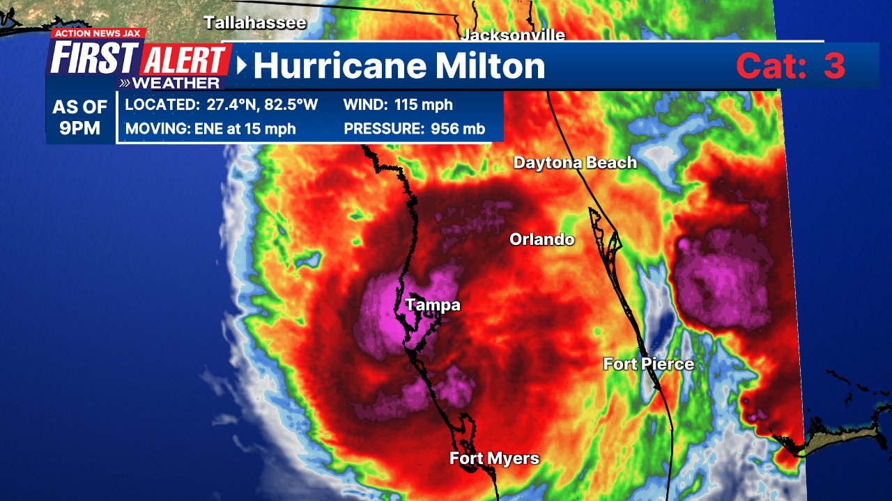
Once Milton developed (from a tropical depression), the tropical cyclone was off to the races. From a depression Sat. morning, Milton was a tropical storm in the afternoon... a hurricane 24 hours later.. & a ‘major’ hurricane less than 24 hours later peaking at Cat. 5 by late Mon.!

Once a Cat. 5 Monday, Milton went through an eyewall replacement cycle Mon. night causing weakening. But once fully recovered later Tue., Milton went back to a violent Cat. 5 hurricane. From there Milton entered increasing vertical mid & upper level wind shear... friction from the Fl. Peninsula... & drier continental air wrapping in on the counterclockwise circulation to induce weakening - well forecast within most circles - upon approach to the Florida landfall.
It’s worth noting that hurricanes that are weakening while moving inland have a general tendency to not mix down the strongest winds nor have the greatest storm surge. Examples include Beryl in Texas in early July... Idalia late Aug., 2023... & Lili in 2002. Strengthening hurricanes upon approach to land generally have much more impact such as Helene this year, Ian in 2022, Sally in 2020, Michael in 2018 & even Hermine (”only” a Cat. 1) in 2016. Steady state hurricanes are capable of wind & surge above or below what would be expected depending on the strength & size previously such as Matthew/2016, Ike in 2008, Katrina in 2005 & Ivan/2004.
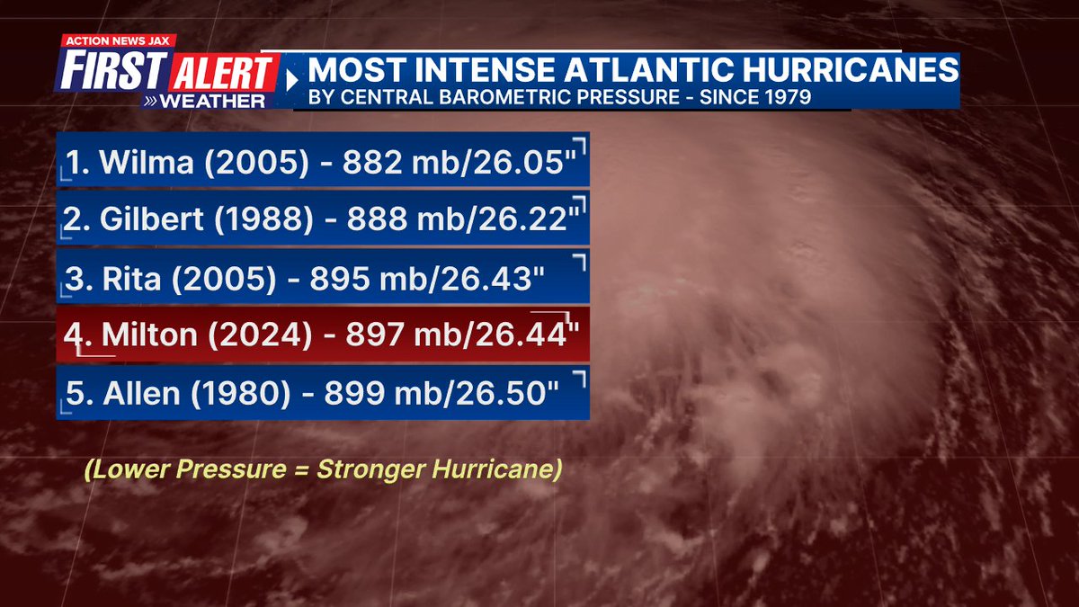
And ‘major’ hurricanes in October are not at all ‘unusual’:
Strong October Atlantic hurricanes are anything but rare. And when hurricanes form in Oct., Florida is often a target. #HurricaneMilton will now be added to the list. @actionnewsjax @wokvnews #FirstAlertWx pic.twitter.com/a46NWI3X7m
— Mike Buresh (@MikeFirstAlert) October 9, 2024
FIRST ALERT FORECAST:
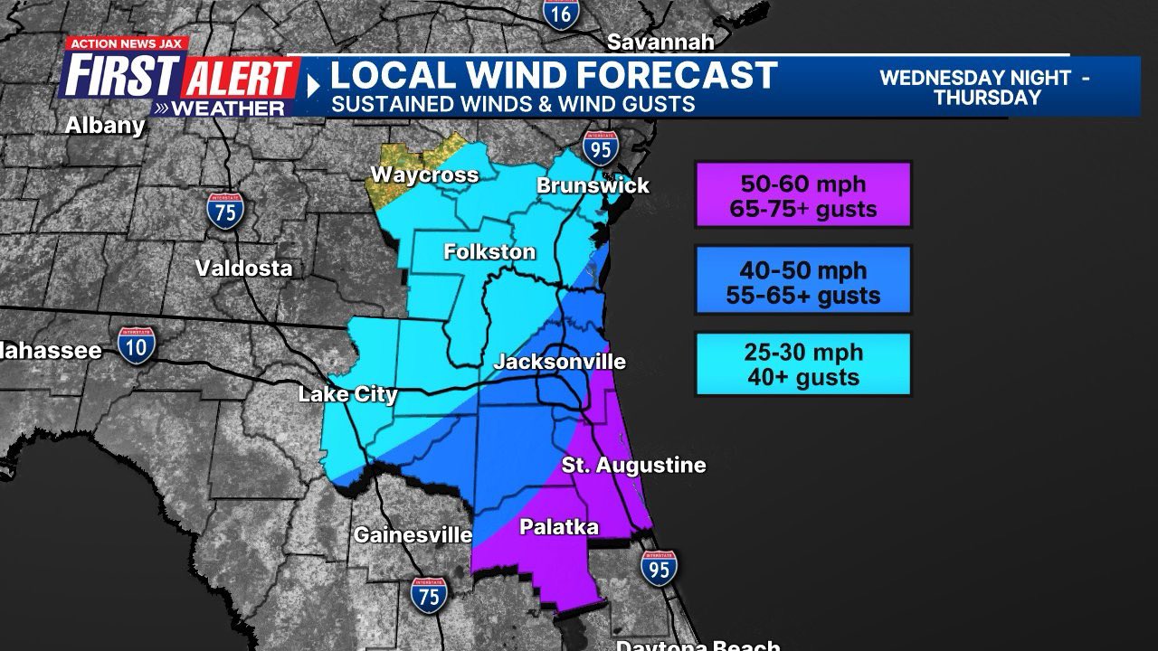
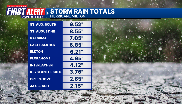
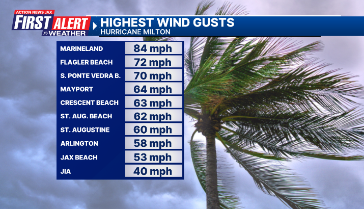
Well - it wasn’t perfect, but it was in line with what happened. We heavily messaged & forecasted that the area so hard hit by Helene would escape the worst of Milton. That was a good message/forecast & accurate. The toughest part of the forecast was right over Duval Co. & NE Fl. regarding the heaviest rain & strongest winds. We knew there would be a sharp gradient from fewer impacts vs. very significant impacts. Power outages ended up being relatively low for Duval but was still very significant for St. Johns & Putnam Co. Below is our general forecast vs. reality:

#firstalertwx from Drew in St. Augustine- transformers blowing in the distance @ActionNewsJax @WOKVNews e pic.twitter.com/9NiupDqt9D
— Mike Buresh (@MikeFirstAlert) October 10, 2024
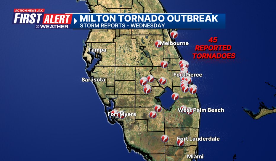
TORNADOES:
Milton helped to produce one of the most prolific tornado outbreaks in Florida history. It was obvious that the tornado outbreak would not be able to push northward into NE Fl. which we were accurate on. But the right front quadrant - east side - of Milton was ripe for tornadoes (high instability thanks to some dry air aloft, surface heating & off-the-charts shear [winds from the SE at ground level to out of the SW aloft with very strong speeds]). The Melbourne N.W.S. confirmed 7 tornadoes including a rare EF-3 tornado on the ground for 21 miles killing 6 people. The Miami N.W.S. also confirmed at least three EF-3 tornadoes. An EF-3 tornado was also confirmed in Fort Myers - a first for SW Florida.
#firstalertwx Fort Pierce, Fl tornado late Wed., 10/09 #HurricaneMilton @ActionNewsJax @WOKVNews pic.twitter.com/hrljDCmT2g
— Mike Buresh (@MikeFirstAlert) October 10, 2024
Video of the violent tornado in Fort Pierce, Florida.#flwx pic.twitter.com/fI9ujjK4xx
— Weather Track US (@weathertrackus) October 9, 2024
We - Action News Jax - were blessed to have access to Nick Stewart & his storm chasing stream.
Chasing Florida's Extreme #Tornado Outbreak caused by Hurricane #Milton. #FLwxhttps://t.co/LIyuLFfdAw
— Nick Stewart (@NStewWX) October 12, 2024
It’s worth emphasizing - & the First Alert Weather team did so - that the dangers - damaging winds & flooding - of a tropical cyclone extend well beyond the center as well as the forecast cone. Recall that a skinnier cone simply implies a higher confidence track forecast:

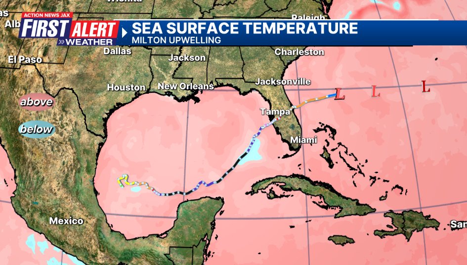
Unlike “Helene” which was fast-moving & strengthening late right up to landfall... Milton caused some upwelling & cooler sea surface temps. (usually lasts about 7-10 days before mixing out):
Big shout out to JEA & all utility companies:

It’s been a busy last 10 years - especially last 7 years - for Florida & ‘major’ (Cat. 3+) hurricanes:

The U.S. & Gulf Coast has had a rough hurricane season (the record for U.S. hurricane landfalls in a single season is 6):

Some might remember the dog that was found by the Tampa FHP (shout out to Fl. HP!) tied to a fence... he is well, adopted & given the name “Trooper”! The owner has been found & arrested.


And a nostalgic “Milton” story from the Associated Press * here *, photo credit to AP as well:
“As an award-winning scientist, Peter Dodge had made hundreds of flights into the eyes of hurricanes — almost 400. On Tuesday, a crew on a reconnaissance flight into Hurricane Milton helped him make one more, dropping his ashes into the storm as a lasting tribute to the longtime National Oceanic and Atmospheric Administration radar specialist and researcher.”
Jacksonville N.W.S. Milton summary * here *.
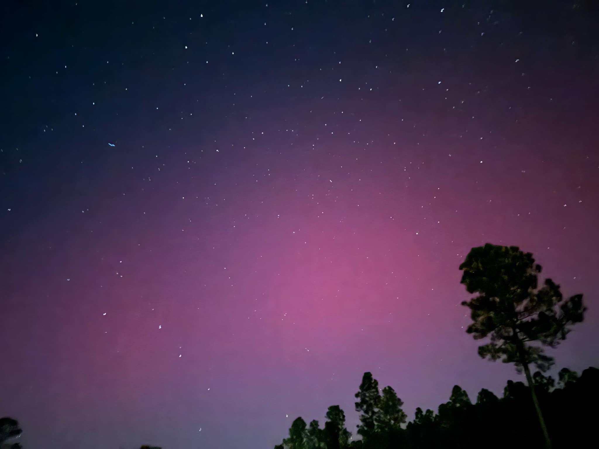
Moving on to our night skies & there’s a lot to talk about/look out! The Aurora Borealis (northern lights) were visible in NE Fl./ SE Gal. for the 2nd time within the last 5 months. The sun remains “stormy” so there may be more opportunities in the months ahead but realize the northern lights & forecasting them are very fickle. NASA forecast * here *. The image below is from Erin Hires, Byrceville (near the Duval/Nassau Co. line):
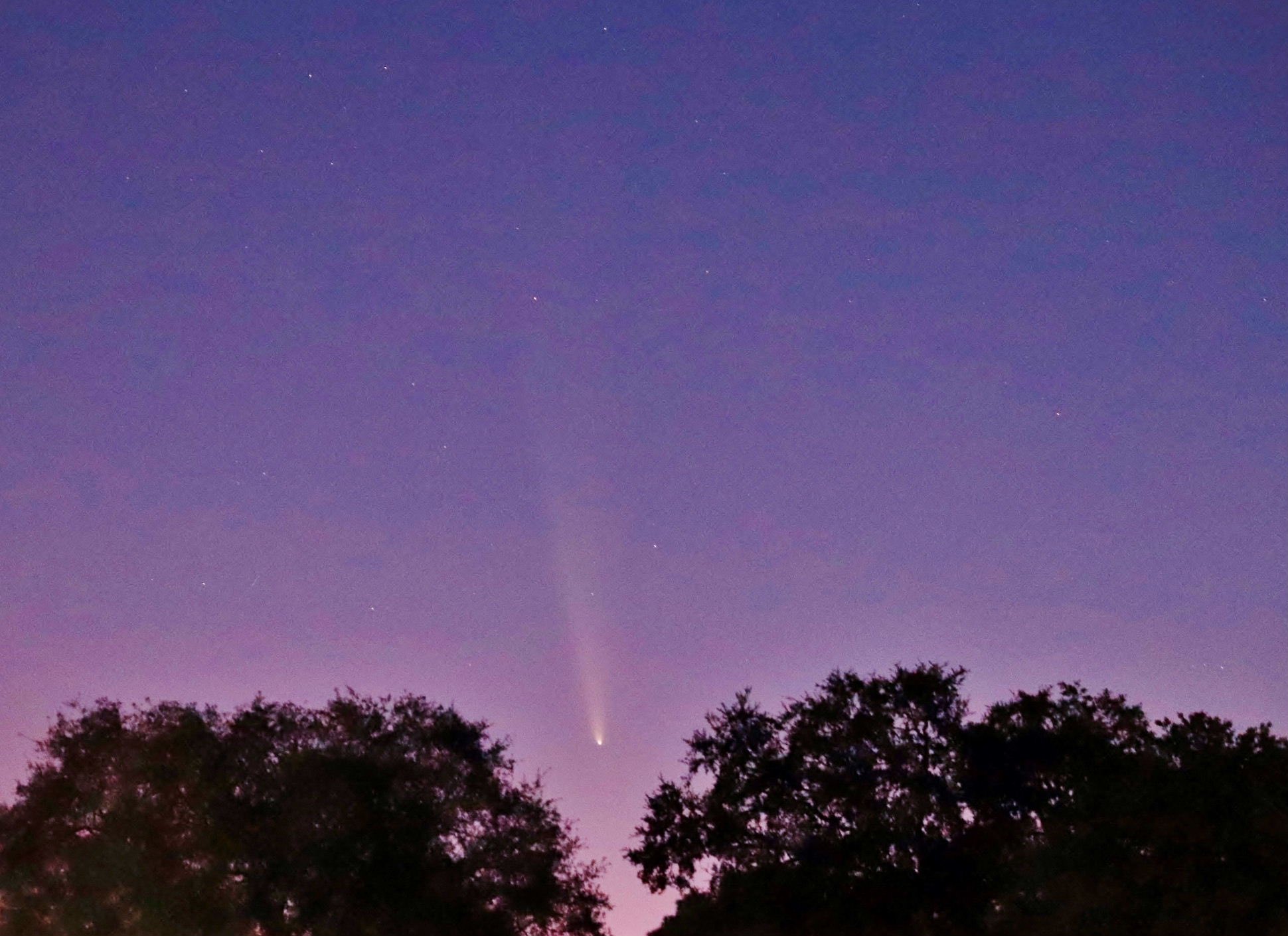
We do get a wonderful view of the comet ‘Tsuchinshan-Atlas’ over the next few weeks. An explainer * here * from “Sky & Telescope”.
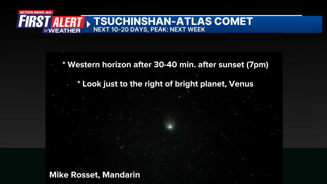

Photo below by Mike Rosset, Mandarin:
The American Meteorological Society (AMS):
For tens of thousands of years Comet Tsuchinshan-ATLAS (pronounced sue-cheen-SHAHN), also known as C/2023 A3, has been falling in toward the Sun. Astronomers discovered it in early 2023 as a tiny, distant speck in large telescopes. Having just swung around the Sun on September 27th, it’s now passing its closest by Earth, coming within 44 million miles of us on
October 12th. For the next days, it will be showing off during its brief time of glory in the Sun’s warmth and light.
How to See the Comet
“As soon as October 11th, ambitious comet spotters may pick up the comet during twilight just above the western horizon,” says Sky & Telescope Contributing Editor Bob King. “Binoculars will help you see the comet throughout its appearance.”
About 40 minutes after sunset on Friday, find a spot with a good view down to the western horizon. The first thing that will catch your eye will be the bright planet Venus, the Evening Star—that’s your starting point. Hold your fist out at arm’s length; the comet is about 2½ fists to Venus’s right. The comet will still look tiny in Friday’s twilight—like a hazy star with a small tail—and will set while twilight is still in progress.
Comet Origins & Fate
The comet came by its name from its discovery at both China’s Purple Mountain Observatory (tsuchinshan means “purple mountain”) and South Africa’s Asteroid Terrestrial-impact Last Alert System (ATLAS). The two teams picked up the comet independently in early 2023, when it was still beyond Jupiter’s orbit and some 50,000 times fainter than the faintest stars visible to the unaided eye.
The comet’s solid nucleus, the source of the whole show, is a dirty space iceberg, probably just a few miles wide. It fell in toward the Sun from the cold and dark outer solar system, originating in a region referred to as the Oort Cloud. As the comet nears the Sun’s warmth, some of the ices in its nucleus (water, frozen carbon dioxide, and other volatiles) evaporate. The ensuing haze of sunlit dust and fluorescing gas forms the comet’s visible head and streaming tail, which can be many millions of miles long.
In September, Comet Tsuchinshan-ATLAS was visible to the unaided eye before dawn in the Southern Hemisphere, then before dawn in the northern parts of the world, brightening all the while. It swung around the Sun on September 27th and, fortunately for us, enters the Northern Hemisphere’s evening sky while still glowing brightly.
But as it recedes from both Earth and the Sun, it will dwindle relatively quickly—there’s no hope of seeing it with the unaided eye on Halloween evening. It will probably remain visible through binoculars through early November. Its orbit is only weakly gravitationally bound to the Sun, so it will spend future ages coasting ever farther out of the solar system, probably never to return.
So... the night skies in the coming weeks (Sky & Telescope):
Oct. 14 (evening): In the southeast, the waxing gibbous Moon is 3½° lower left of Saturn.
Oct. 19 (evening): The Moon, just two days past full, trails the Pleiades by 4° in the east. Jupiter and Aldebaran follow close behind.
Oct. 20 (evening): The waning gibbous Moon is 5° upper left of Jupiter in Taurus.
Oct. 20–21 (all night): The Orionid meteor shower peaks. However, a waning gibbous Moon will hamper viewing.
Oct. 23 (morning): The Moon, just shy of third quarter, forms a triangle with Castor and Pollux high in the east.
Mars sits below this trio.
Oct. 25 (dusk): Venus blazes 3° upper right of Antares low in the southwestern sky.
Oct. 26 (morning): Regulus is 3° to the lower right of a waning crescent Moon in Leo.
Moon Phases
First Quarter October 10 2:55 p.m. EDT
Full Moon October 17 7:26 a.m. EDT (Hunter’s Moon)
Last Quarter October 24 4:03 a.m. EDT
Some help please!....
From the University of South Florida & the NOAA Vortex-USA project:
Dr. Laura Myers from the University of Alabama, Dr. Jennifer Collins from the University of South Florida, and Dr. David Roueche from Auburn University are conducting a study called “Risk and Crisis Communication, Impact Assessment Standards, and Best Practices for Effective Sheltering Decisions in Response to Structural Vulnerability.”
This study is funded under NOAA-OAR-WPO-2023-2007516: Verification of the Origins of Rotation in Tornadoes Experiment in the United States (VORTEX-USA). The goal of this study is to gain a more in depth understanding of severe weather risk faced by households when taking action from severe weather warnings.
Your participation in this research study is completely voluntary. This study will begin with an online survey of households in your region to determine severe weather awareness and preparedness for severe weather impacts to your residence. You will then have the options of also participating in two additional phases of the study.
· Residential assessment of the structural wind strength of your residence: Optional participation in the residence structure assessment will give you a classification of your residential structure for EF0 to EF5 wind speeds to support your severe weather sheltering decisions.
· Severe weather event interviews: You will have the option to participate in brief virtual interviews about your sheltering decisions for actual severe weather events.
Here is the link to the online survey of households in either English or Spanish:
English:
https://bit.ly/VortexEnglishFL

Spanish:
https://bit.ly/VortexEspanolFL

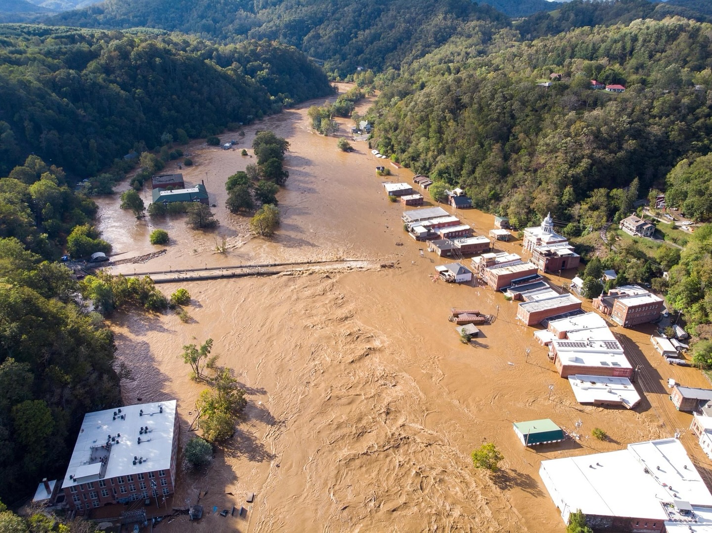
Lastly.... clean-up & recovery continues after devastating hurricane “Helene”. North Carolina State story: * here *. The final numbers - from Florida to Kentucky - continue to be tallied - a record setting natural disaster, no doubt.
Photo from “Old Marshall Jail Hotel”:
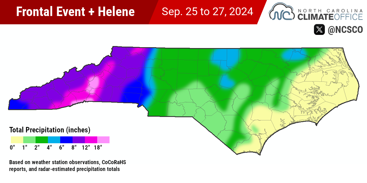
From N. Caroina DOT: