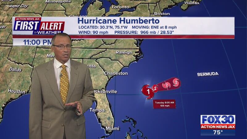
5 p.m. update:Hurricane Humberto has continued to strengthen while moving away from our coast. A Tropical Storm Watch has been issued for Bermuda.
Hurricane Humberto has continued to strengthen while moving away from our coast. A Tropical Storm Watch has been issued for Bermuda. #FirstAlertWX @ActionNewsJax pic.twitter.com/sUVvJ90VbZ
— Stacey Garvilla (@StaceyGarvilla) September 16, 2019
5 a.m. update: Humberto remains a category 1 hurricane with winds of 85 mph that's continuing to strengthen. It is currently moving away from the U.S. east coast and is about 760 miles west of Bermuda. Humberto is moving northeast at 5 mph.
Hurricane #Humberto now has winds of 85 mph. Moving away from the U.S. east coast. Interests in Bermuda should monitor the forecast closely. #FirstAlertWX pic.twitter.com/dbYXsBeDGb
— Garrett Bedenbaugh (@wxgarrett) September 16, 2019
Hurricane Humberto is moving away from the U.S. this morning and is forecast to be near Bermuda early Thursday. High surf and rip currents will continue at our local beaches today.
10:50 p.m. update: Humberto becomes a hurricane.
5 a.m. update: Tropical Storm Humberto is almost at hurricane strength. The storm is at its closest approach to Jacksonville.
#firstalertwx #Humberto just about at hurricane strength & at its closest approach to #Jacksonville, FL - more than 200 miles away. Hurricane soon but turning sharply east away! from the U.S. @WOKVNews pic.twitter.com/vmNESTUM6w
— Mike Buresh (@MikeFirstAlert) September 15, 2019
11 a.m. update: Tropical Storm Humberto strengthening and expected to become a hurricane by tonight.
Tropical Storm Humberto now at 65 mph sustained winds and moving due north at 7 mph. Strenthening off our coast later this evening - about 230 miles away! #FirstAlertWX @ActionNewsJax pic.twitter.com/nN4RA2ewyL
— Stacey Garvilla (@StaceyGarvilla) September 15, 2019
5 a.m. update: No major changes in the forecast for our local area. Tropical Storm Humberto remains about 225 miles east of Jacksonville at the closest approach.
No major changes in the forecast for our local area with the 5 AM advisory. Tropical Storm Humberto remains about 225 miles east of Jacksonville at the closest approach. #FirstAlertWX @ActionNewsJax pic.twitter.com/mkEdpPeHGp
— Stacey Garvilla (@StaceyGarvilla) September 15, 2019
11 p.m. update: Tropical Storm Humberto is slowly strengthening and is expected to near hurricane strength Sunday morning.
11 PM Update: #Humberto slowly strengthening, expected near hurricane strength tomorrow AM. Big turn east Sunday into Monday #FirstAlertWX pic.twitter.com/JyuJZTUlYw
— Corey Simma (@CSimmaWX) September 15, 2019
5 p.m. update: Tropical Storm Humberto is expected to become a category 1 hurricane by late Sunday night or early Monday as it starts moving out to sea.
Watch latest update below from First Alert Weather Meteorologist Corey Simma:
The storm has maximum sustained winds of 50 mph and is currently located about 70 miles north of Great Abaco Island. It is moving NNW at 7 mph. It will be about 200 miles off the coast of Florida.
5 PM Update: #Humberto expected to become a hurricane late Sunday/early Monday as it starts moving out to sea #FirstAlertWX pic.twitter.com/TAz9YlyQJi
— Corey Simma (@CSimmaWX) September 14, 2019
11:00 a.m. update: Tropical Storm Humberto has not moved in the last couple of hours but has strengthened to 50 mph winds. Expected to strengthen to a CAT 1 Hurricane about 230 miles east of Jacksonville on Sunday.
MORE: Buresh Blog, Talking the Tropics with Mike, Download the free First Alert Weather app
The 11 AM advisory is in and Tropical Storm Humberto has not moved in the last couple of hours but has strengthened to 50 mph winds. Expected to strengthen to a CAT 1 Hurricane about 230 miles east of Jacksonville on Sunday. #FirstAlertWX @ActionNewsJax pic.twitter.com/S45EapGIjM
— Stacey Garvilla (@StaceyGarvilla) September 14, 2019
5 a.m. update: Tropical Storm Humberto another 15 to 20 miles east of Jacksonville. Impacts for the area will include breezy weekend with showers increasing Sunday and dangerous rip currents and surf at the beaches.
The 5 AM track update shifted Tropical Storm Humberto another 15-20 miles east of Jacksonville. Impacts for us will be a breezy weekend with showers increasing Sunday and dangerous rip currents/surf at the beaches. #FirstAlertWX @ActionNewsJax pic.twitter.com/t2MtuzrlgK
— Stacey Garvilla (@StaceyGarvilla) September 14, 2019
10:50 p.m. update: Tropical depression upgraded to Tropical Storm Humberto
#firstalertwx t.d. #9 strengthens into tropical storm #Humberto... updated forecast even farther to the east & now more than 200 miles east of Jacksonville, Fl while making turn to the E/NE @WOKVNews pic.twitter.com/A3Fex7iEki
— Mike Buresh (@MikeFirstAlert) September 14, 2019
5 p.m. update: The tropical disturbance near the Bahamas has become tropical depression No. 9. The forecast track continues to shift east with few impacts for Northeast Florida and Southeast Georgia despite the system intensifying through early next week. There will be dangerous surf at our beaches.
2 p.m. update: No significant changes to the 2 p.m. advisory. Meterologist Garrett Bedenbaugh says the storm is getting better organized though.
11 a.m. update: The newest track shows the tropical disturbance shifting east again. It could become a tropical depression later today.
11 am forecast track shifts to the right again. This keeps the likely tropical storm off our coast on Sunday. #FirstAlertWX pic.twitter.com/2pTxyMhk1w
— Garrett Bedenbaugh (@wxgarrett) September 13, 2019
A tropical disturbance is over the central and southern Bahamas. It is forecast to gradually organize Friday or Saturday as it slowly makes its way north.
The system is forecast to strengthen into a tropical storm by Saturday and will be called Humberto.
The First Alert Weather team is also tracking two more tropical waves out in the Atlantic basin that have the potential for some development next week.
Here is the latest advisory for our tropical disturbance over the Bahamas. Track shifted to the "right." #FirstAlertWX pic.twitter.com/px8hV82WZM
— Garrett Bedenbaugh (@wxgarrett) September 13, 2019
Here is what has changed as of this morning with the tropical disturbance over the Bahamas. #FirstAlertWX pic.twitter.com/0QpcyqSC4v
— Garrett Bedenbaugh (@wxgarrett) September 13, 2019
Cox Media Group


