JACKSONVILLE, Fla. — Action News Jax’s First Alert Weather Team is tracking another hot and humid day with highs in the lower to mid-90s.
Feels-like temperatures are expected to reach 100 to 105+.
A few showers and thunderstorms are expected in the afternoon moving west to east. First Alert Meteorologist Garrett Bedenbaugh says some will contain very heavy rain.
WATCH THE FORECAST | DOWNLOAD THE APPS
Highs will remain in the lower to mid-90s tomorrow with isolated afternoon showers and storms.
The weekend will be hot and humid with highs in the lower to mid-90s. There will be a few showers and storms on Saturday afternoon and more coverage on Sunday afternoon.
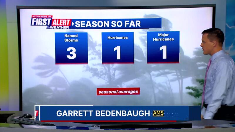
There are currently no areas of concern in the tropics.
Action News Jax’s First Alert Weather Team will continue to monitor the forecast and update you throughout the day.
Follow Action News Jax Meteorologists on Twitter for updates:
Mike Buresh | Garrett Bedenbaugh | Corey Simma | Trevor Gibbs
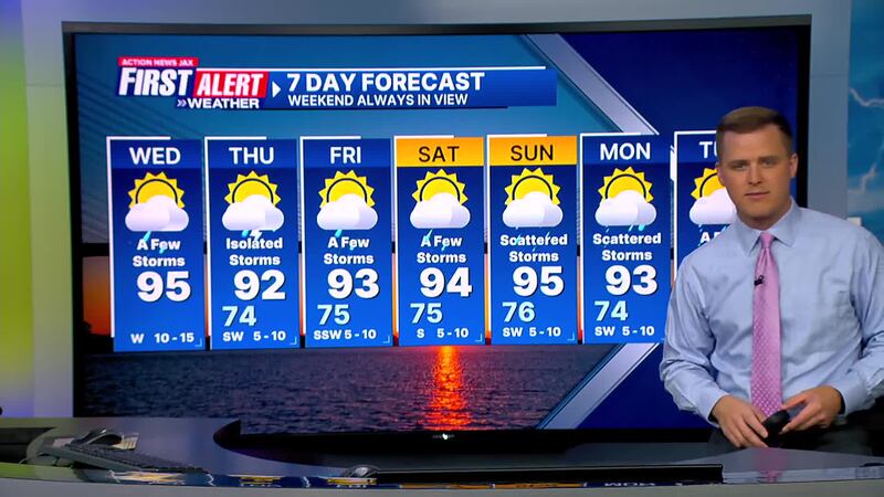
Here’s a look at your First Alert 7-Day Forecast:
TODAY: Partly cloudy and hot with a few showers and storms. HIGH: 95 (Feels like: 103-105+)
TONIGHT: Storms ending, then partly cloudy and muggy. LOW: 74
LISTEN: Mike Buresh ‘All the Weather, All the Time’ Podcast
THURSDAY: Partly cloudy with isolated afternoon storms. High 92/Low 74
FRIDAY: Partly sunny with a few storms. High 93/Low 75
SATURDAY: Partly sunny with a few storms. High 94/Low 75
SUNDAY: Partly sunny with scattered showers/storms. High 95/Low 76
MONDAY: Partly sunny with scattered showers/storms. High 93/Low 74
TUESDAY: Partly sunny with a few showers and storms. High 94/Low 73
INTERACTIVE RADAR: Keep track of the rain as it moves through your neighborhood
SHARE WITH US: Send us photos of the weather you’re seeing in your area