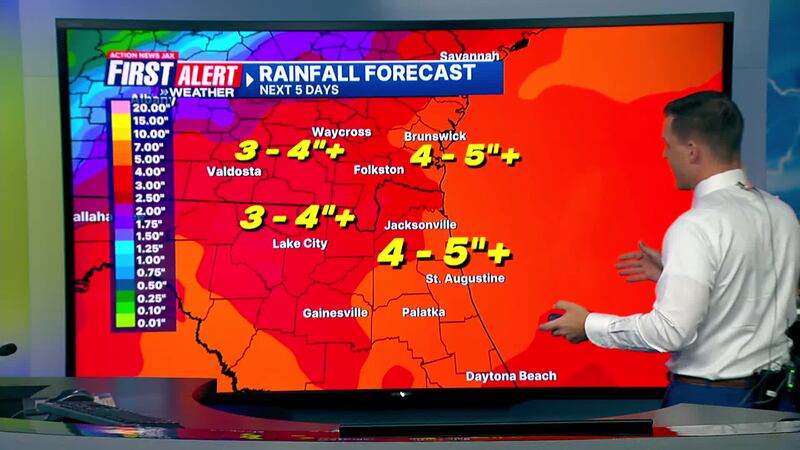
JACKSONVILLE, Fla. — Action News Jax’s First Alert Weather Team is tracking the possible development of a tropical system.
According to Chief Meteorologist Mike Buresh, the probability of a tropical system near Florida looks high late in the weekend or early next week. His concerns are centered around heavy rain, which can be very heavy, moderately rough seas and surf, a high rip current risk and isolated tornadoes and water spouts. Winds should be gusty but not severe.
Florida is the “fork in the road” for the direction of movement and speed of this storm. There is a potential for a stronger tropical system in the longer range, so Buresh is issuing a heads-up to all of Florida, especially the Central and Eastern Gulf Coast the U.S. East Coast.
WATCH THE FORECAST | DOWNLOAD THE APPS
Buresh says gusty rain and thunderstorm squalls will impact Hispaniola and nearby islands, the Central and Southern Bahamas, Jamaica and Cuba into Saturday. Florida will be affected later in the weekend or early next week.
In addition, Buresh wants to remind viewers that the National Hurricane Center shading below the area on the radar is where the development of a tropical storm might occur. It’s not a forecast cone like one would see when and if a tropical cyclone actually develops.
Follow Action News Jax Meteorologists on Twitter for updates:
Mike Buresh | Garrett Bedenbaugh | Corey Simma | Trevor Gibbs
Here is a list of watches/warnings now in effect:
Tropical Storm Watches:
- The Florida Keys south of Card Sound bridge including the Dry Tortugas
- The southern coast of the Florida peninsula east of East Cape Sable to the Card Sound Bridge
- The west coast of the Florida peninsula north of Bonita Beach to Aripeka
Tropical Storm Warnings:
- Southwest coast of the Florida peninsula from East Cape Sable to Bonita Beach
A Tropical Storm Watch means that tropical storm conditions are possible within the watch area, generally within 48 hours.
A Tropical Storm Warning means that tropical storm conditions are expected somewhere within the warning area within 36 hours.
Read: Talking the Tropics With Mike: Strong tropical wave to Gulf then north/northeast - Florida soaker
Potential System Hazards:
RAINFALL: Potential Tropical Cyclone 4 is expected to produce rainfall totals of 4 to 8 inches, with maximum rainfall totals up to 12 inches, across portions of Florida and near the Southeast U.S. coast this weekend through Wednesday morning. This rainfall could result in areas of flash and urban flooding, with isolated river flooding possible.
WINDS: Tropical storm conditions are expected in the warning area late Saturday and Saturday night. Tropical storm conditions are possible in the watch area in the Florida Keys and the southern Florida peninsula by Saturday or Saturday night. Tropical storm conditions are possible in the watch area along the Florida west coast Saturday night or Sunday.
STORM SURGE: The combination of storm surge and tide will cause normally dry areas near the coast to be flooded by rising waters moving inland from the shoreline. The water could reach the following heights above ground somewhere in the indicated areas if the peak surge occurs at the time of high tide.
- Aripeka, FL to Card Sound Bridge, FL...1-3 ft
- Tampa Bay...1-3 ft
- Charlotte Harbor...1-3 ft
LISTEN: Mike Buresh ‘All the Weather, All the Time’ Podcast
Keep up with the latest on the tropics with “Talking the Tropics with Mike,” which is updated daily.
Action News Jax’s First Alert Weather Team will continue to monitor the forecast and update you throughout the day.
INTERACTIVE RADAR: Keep track of the rain as it moves through your neighborhood
SHARE WITH US: Send us photos of the weather you’re seeing in your area


