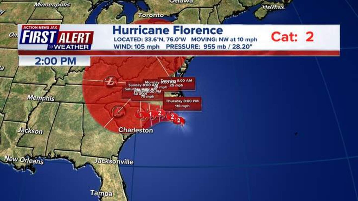
Here's the very latest on Hurricane Florence, which is getting closer and closer to the North Carolina and South Carolina coast:
OFFICIAL SITE: National Hurricane Center
The outer bands of Hurricane Florence are beginning to brush the coast of the Carolinas. Right now, Florence is a Category 2 storm with sustained wind holding at 110 mph and gusts at 130 mph. It is projected to re-strengthen to 1 mph shy of a Category 3 before it makes landfall.
FREE DOWNLOAD: Our feature-packed weather app works anywhere
Power outages already are creeping up along the North Carolina coast as tropical storm-force winds started sweeping over land. Electric utilities and cooperatives reported about 12,000 outages statewide as of early Thursday afternoon, with nearly all of them at the coast.
An emergency management official in one of the most populated areas of coastal North Carolina says winds from the storm have already arrived and other impacts won't be far behind.
New Hanover County Emergency Management Director Steven Still said Thursday that residents who didn't evacuate should expect 60 mph winds by 7 p.m. that would eventually increase to 100 mph or more.
Latest Florence outlook
Florence is a Category 2 storm moving toward the coast at 12 mph. Florence's max sustained winds have dropped to 110 mph.
LIVE: American Flag near Cape FearLIVE: American Flag near Cape Fear LATEST Florence track/path: https://www.actionnewsjax.com/weather-detail?mapID=273948847
Posted by Action News Jax on Thursday, September 13, 2018
The landfall looks to be early Friday morning near Wilmington, N.C. Florence could make landfall as a Category 2 or 1 storm. Highest impact areas will be from Myrtle Beach northward to the Outer Banks, with dangerous currents and surf.
For more analysis from Chief Meteorologist Mike Buresh, check out his (updated daily) Talking the Tropics.
OFFICIAL SITE: National Hurricane Center
The storm is also expected to slow down a great deal and could dump three feet of rain on some areas. Flooding could extend far inland. For additional coverage from our sister station WSOC-TV Charlotte, click here.
Florence will weaken to a Tropical Storm and then a Tropical Depression but will still dump a lot of rain along its path.
Forecasters at the National Hurricane Center said they don't expect it to strengthen from a Category 2 hurricane before it moves ashore, but the real problem will be water as Florence lingers along the coast through Saturday.
#firstalertwx "Talking the Tropics With Mike": #Florence takes aim on the Carolina's: https://t.co/XYqsyffjCW @WOKVNews pic.twitter.com/5Rme9iIVes
— Mike Buresh (@MikeFirstAlert) September 13, 2018
Meteorologist Garrett Bedenbaugh and news anchor John Bachman are in the Carolinas for team coverage on the storm.
Bedenbaugh is in Isle of Palms in South Carolina where lots of residents are checking out the five to six foot surf -- despite mandatory evacuation order in place. He said its a "surfers paradise."
5-6 footers at Isle of Palms- up from yesterday. #Florence A lot of surfers out here. pic.twitter.com/o0yNlpUeo3
— Garrett Bedenbaugh (@wxgarrett) September 13, 2018
Lot of folks checking out the surf at Isle of Palms, SC #Florence (evacuation order in place) #SCwx @SCEMD pic.twitter.com/nSy0QmGE04
— Garrett Bedenbaugh (@wxgarrett) September 13, 2018
Sandbagging station is busy in Murrells Inlet, SC just south of Myrtle Beach @ActionNewsJax pic.twitter.com/Cn4KKrgSGI
— John Bachman (@BachmanANjax) September 13, 2018
Jacksonville, Southeast Georgia Impacts of Hurricane Florence
Florence is expected to stay well north of the Jacksonville. Local impacts will only be felt at the beaches where the storm has caused rough seas and surf and rip currents.
Action News Jax has seen several surfers enjoying Hurricane Florence's local impacts: rough waves at Jacksonville Beach.
First Alert Meteorologist Arielle Nixon asks that surfers please be safe.
"Surf with a buddy or spotter and try to do so near a lifeguard if possible," Nixon said.
I know surfers are loving this and I don't blame you, but please be safe. Surf with a buddy or spotter and try to do so near a lifeguard if possible. #firstalertwx pic.twitter.com/sRAsjinXSt
— Arielle Nixon (@NixonFirstAlert) September 13, 2018
Conditions in Southeast
Georgia
will see similar impacts as Jacksonville -- despite its closeness to the center of the storm.
Cox Media Group


