
Jacksonville, Fl. — The “Buresh Bottom Line”: Always be prepared!.....First Alert Hurricane Preparation Guide... City of Jacksonville Preparedness Guide... Georgia Hurricane Guide.
STAY INFORMED: Get the * FREE * First Alert Weather app
FREE NEWS UPDATES, ALERTS: Action News Jax app for Apple | For Android
WATCH “Preparing for the Storm”
WATCH “The Ins & Outs of Hurricane Season”
READ the First Alert Hurricane Center “Preparation Guide”
Federal Alliance for Safe Homes (FLASH) * here *.
***** ALWAYS CHECK & RE-CHECK THE LATEST FORECAST & UPDATES! ****
Tropics threats for Jacksonville/NE Florida/SE Georgia: Given *current forecasts*, heavy rain, a few tornadoes/waterspouts, gusty winds & rip currents at area beaches will be a growing threat for NE Fl./SE Ga. Wed. night through Thu. into early Fri. due to landfalling Helene at least a couple hundred miles west of Jacksonville. How significant these impacts are will ultimately depend on the exact track & strength of Helene. Right now - the I-75 corridor will have the highest winds in N. Central Florida.
All areas from Mississippi to Florida need to stay up to date on the latest forecasts for mid to late parts of the upcoming week. Those in the Fl. Panhandle & west coast of Florida should be well underway with hurricane preps with these preparations complete by at least sunrise Thursday. The peak time for impacts will be Thu.-Thu. night for Florida... Friday for Georgia & parts of the Carolina’s... even as far north as Tennessee.
“Buresh Bottom Line”:
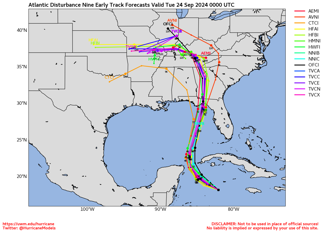
* As expected... “Helene” has formed over the Northwest Caribbean... was upgraded to a tropical storm Tue. morning & a hurricane Wed. morning. While consistency amongst the models has been lacking during the past week, agreement has increased markedly during the past couple days, though pretty significant differences remain on exact track & intensity. Don’t get caught up with unreliable sources & crazy postings on social media & elsewhere. Landfall looks to be this Thu. afternoon/evening near the Big Bend/Eastern Panhandle as a ‘major’ Cat. 3+ hurricane. Due to its swift movement inland, wind damage will occur well inland into at least Georgia & perhaps parts of the Western Carolina’s & as far north as Tennessee.
*** Do not get caught off guard & stay up to date on the latest forecasts. Everyone from Alabama to Florida - & especially the Fl. Panhandle to the Florida west coast into Georgia & Tennessee should prepare for impacts from “Helene”. ***
IMPACTS FOR JACKSONVILLE/NE FLORIDA & SE GA.:
* The most significant impacts Thu. through Thu. night into early Fri. Expect rapidly improving weather conditions - but still breezy - through the day Friday. Forecasts *subject to change & updates!*
* WINDS - near/west of I-75 including Lake City, Fl. - sustained winds 50-70 mph, gusts 70-80+ mph
I-75 to Highway 301: sustained winds 40 up to 50 mph, gusts 55-65+ mph
I-95 corridor: sustained winds 25-35 mph, gusts 45-55+ mph
Beaches, coast, intracoastal: sustained winds up to 50 mph, gusts 55-65+ mph
* STORM SURGE - SE Duval/St. Johns Co.: 1-3 feet...
NE Duval, Nassau, FL... Camden, Glynn, Ga: 2 - 3(+) feet.
St. Johns River: 1 -3 feet but higher values - up to 4 feet for downtown Jacksonville will be possible due to a period of strong winds from the south pushing water up & out of the riverbank Thu. afternoon & evening.
* TORNADOES & WATERSPOUTS - a few Wed. night through Thursday night & there are indications of longer than average ground tracks - & intensity - by NE Fl./SE Ga. standards.
* RAINFALL: 3 - 5+ inches from Lake City, Fl. to Waycross, Ga.... 2-4 inches east of I-75 to Highway 301... 1-2 (3″ in spots) inches east of Highway 301 to the coast including most of Jacksonville/Duval Co.


The Atlantic Basin Overview:
(1) A Storm Surge WARNING: Indian Pass southward to Flamingo ... Tampa Bay ... Charlotte Harbor
A Hurricane WARNING: Anclote River to Mexico Beach ... Cabo Catoche to Tulum, Mexico including Cozumel
A Storm Surge WATCH: West of Indian Pass to Mexico Beach
A Hurricane WATCH: Cuban province of Pinar del Rio ... Englewood to Anclote River, including Tampa Bay
A Tropical Storm WARNING: Florida Keys, including the Dry Tortugas ... Flamingo to Anclote River, including Tampa Bay ... West of Mexico Beach to the Okaloosa/Walton County Line ... Flamingo northward to South Santee River ... Lake Okeechobee ... Rio Lagartos to Cabo Catoche, Mexico ... Cuban provinces of Artemisa, Pinar del Rio, and the Isle of Youth
A Tropical Storm WATCH: North of South Santee River to Little River Inlet.
All systems are “go” for Helene to strengthen from the Northwest Caribbean to the Southern then Eastern Gulf of Mexico through Thursday. I’ve been hitting on this for well over a week but models have been all over the place on both location & intensity but now are in much better agreement. Landfall is Thursday, Sept. 26th in the evening between approximately 9pm & midnight EDT & will be the 4th U.S. landfalling hurricane of the season. Satellite imagery is concerning showing bursting/intense convection with broad, expanding outflow over the top of Helene indicating very favorable conditions for intensification. With a decent core emerging & a very favorable overall environment, Helene is likely to rapidly intensify.
Anyone with travel plans to - or who lives along - the Eastern Gulf Coast & west coast of Florida needs to pay attention to the latest forecast & would be wise to complete preparations for a hurricane by sunset Wed. night, certainly no later than sunrise Thursday. Any & all travel & evacuation plans should be completed by Thursday morning.
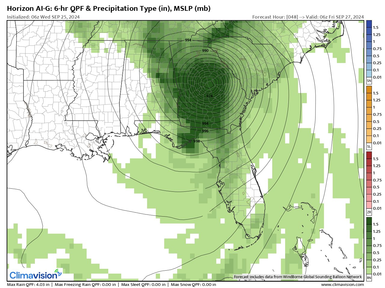
The experimental ‘Horizon’ forecast model by Climavision’s HorizonAI Global Model (this model uses its own data & analysis for initialization of each model run + some AI input) has at least been consistent in indicating tropical development - 9 & 10th image below is for 8pm Thu., Sept. 26 & 2am Fri., Sept. 27th. The model is pointing to a track into the Big Bend of Florida with a landfalling hurricane that is moving quickly to the northeast turning a little more northward further inland. Virtually all other global models are indicating development as well with relatively small - now - deviations in timing (centered on later Thu.) & a narrowing range in intensity & exact location. The GFS has been & still is generally the most aggressive/strongest & farthest to the east - ‘Horizon’ model is similar ... while the European operational model is trending east & stronger. The Canadian model is generally similar to the European though a bit more east & in line with the UKMET model. Eyewall replacement cycles & other structural nuances may dictate intensity once Helene is a mature hurricane but otherwise a powerful hurricane can be expected while traversing the Eastern Gulf upon approach to the upper Fl. coast, Big Bend & Eastern Panhandle.
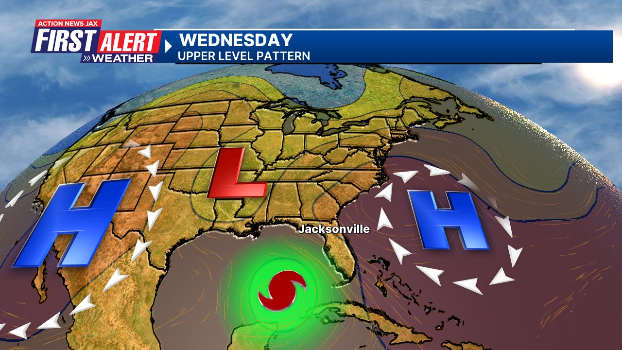
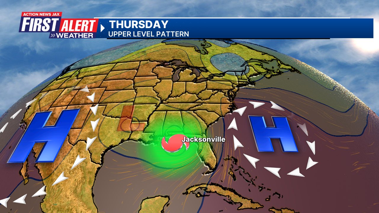
The trek northward is being caused by general troughing aloft over the Lower 48 that gets reinforced this week. The depth & exact position of this trough is key to how sharp the northward movement of Helene is as well as a gradual bend more northwest once inland due to interaction with the upper level trough (the trough draws Helene N/NW then northwest before stalling & weakening further over the Tennessee Valley once in the “belly” of the upper trough).
The Caribbean & Gulf are a climatologically favored area for tropical development later in Sept. & such systems are often steered northward by an ever more active, more meridional jet stream as we start to see the impacts of autumn weather patterns. The water, of course, is very warm & deep oceanic heat content is just about at its annual peak.
The low pressure/tropical development in this area has been gradual (festering) as expected. Now that Helene is becoming better organized, the disturbance should significantly increase in intensity ... & quite quickly. Decreasing shear, warm ocean water - near the surface as well as to deep depths, & high atmospheric humidity all point to favorable conditions for Helene. In addition, the nearby upper level trough to the north over the Lower 48 will aid ventilation over the top of Helene with shear vectors in roughly the same direction as the forward movement - both can aid to intensify tropical cyclones which may occur right up to landfall barring eyewall replacement cycles. The underside of Helene should quickly dry out at & beyond landfall leaving a heavily weighted north side storm as Helene moves swiftly inland & gradually decays while rotating dry continental air into its counterclockwise circulation.
IF this system does indeed move into or very near the Big Bend, it would be the 3rd (Idalia & Debby) hurricane landfall in the last 13 months - a very rare feat.
Anyone living along - or traveling to - the area from Alabama to Florida northward to the Tennessee Valley & Western Carolina’s needs to stay up to date on the latest forecasts & folks in the Fl. Panhandle & west coast of Florida in particular should be moving along with hurricane preparedness measures completing the tasks & any evacuations by Wed. night, sunrise Thursday at the latest.
I would be remiss if I did not mention some early striking similarities between the forecast development over the Gulf & hurricane Michael in 2018. I AM NOT SAYING the developing storm will be as intense but Helene will be developing in a similar area, similar movement with influence from an upper level trough to the north... & forming quickly from next to nothing just a few days prior.
It’s also interesting to note the rapid strengthening of hurricane “John” over the far East Pacific that moved inland on the west (Pacific side) coast of Mexico Mon. night/early Tue. There may be some symmetry with the Gulf system as upward vertical velocities that aided John spread eastward to the Atlantic Basin.

Keep in mind impacts from the storm will extend well beyond the center AND the cone. Do not fixate on the cone or a perceived center point. Remember that a more narrow cone simply means a higher confidence forecast & that dangerous weather conditions will extend way beyond the cone:


The storm surge forecast map below will expand dramatically up the coast soon:


Climavision’s HorizonAI Global Model late Thu., 09/26 for 8pm & 2am EDT Fri., 09/27 respectively (pretty steady trend & track - near or sub 950-955mb/28.00-28.15″) showing landfall 9pm - midnight Thu. with a fast moving, powerful tropical cyclone well inland into & through Georgia. This model is a tad east of the official NHC forecast & some other global models, especially after landfall:

500mb forecast from the GFS for Wed. & Thu. The upper level trough over the Central U.S. + positioning of a high pressure cell over the Western Atlantic & stronger ridge to the west will be key in where a Gulf tropical cyclone might track.

Mid & upper level wind shear across the Gulf & Caribbean increases again over the Central & Northern Gulf. But the shear vectors will not be overly hostile since Helene will be moving N/NE. There will be impressive shear magnitudes at low & mid levels unfortunately helping the potential spin in the atmosphere for tornadoes. The 2nd image is deep oceanic heat content (OHC) + shear.


Radar imagery from South Fl. Water Management District (solid line is ‘Helene’ forecast track previous advisory vs. latest NHC advisory:

Jacksonville/NE Fl./SE Ga. rainfall courtesy GFS & European models:


Heavy rain is forecast along much of the Gulf coast. While it’s recently been drier for NE Fl. & SE Ga., a lot of water remains “in the system” so flooding will be a concern by Thu./Fri.:

(2) A tropical wave over the Eastern Atlantic has high potential for gradual development but early indications are that the system would stay far out to the east over the open Atlantic. Another tropical wave will then follow that one.


‘Velocity potential anomalies’ below still shows “sinking” air (brown lines) across the Atlantic Basin. In such a state, tropical development can occur but overall conditions are not as conducive as when there is overall rising (green lines) air where convection is active. This “pulse” of upward motion is moving eastward toward the Atlantic Basin & may help to be a cause for an uptick in Atlantic activity over the next few weeks.

REMEMBER WHEN A TROPICAL STORM OR HURRICANE IS APPROACHING: Taping windows is *not* recommended & will not keep glass from breaking. Instead close curtains & blinds.
Realize the forecast cone (”cone of uncertainty”) is the average forecast error over a given time - out to 5 days - & *does not* indicate the width of the storm &/or where damage might occur.

The upper oceanic heat content (UOHC) [tropical cyclone heat potential/TCHP] across the SW Atlantic, Gulf & Caribbean is very high:


Water vapor loop (dark blue/yellow is dry mid & upper level air):


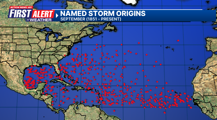
September tropical cyclone origins (early season breeding grounds are the Gulf &/or Western Caribbean:
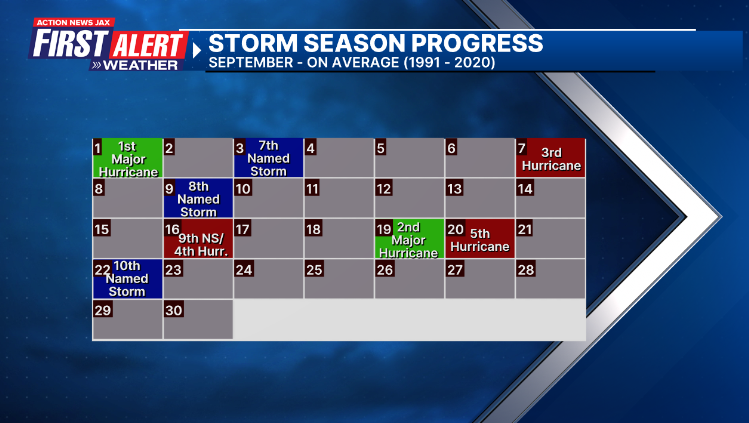
Averages below based on climatology for the Atlantic Basin for September (2 hurricane so far, 3 tropical storms):
Wind shear (red - strong shear; green - low shear):


Saharan dust spreads west each year from Africa driven by the prevailing winds (from east to west over the Atlantic). Dry air = yellow/orange/red/pink. Widespread dust is indicative of dry air that *can* interfere with the development of tropical cyclones. However, sometimes “wanna’ be” waves will just wait until they get to the other side of - or away from - the dust plume then try to develop if other conditions are favorable (we’ve already seen this with Beryl & Debby this year). In my personal opinion, there is way too much “hoopla” about the presence of Saharan dust & how it relates to tropical cyclones. In any case, the peak of Saharan dust typically is in June & July.

2024 names..... “Isaac” is the next name on the Atlantic list (names are picked at random by the World Meteorological Organization... repeat every 6 years). Historic storms are retired [Florence & Michael in ’18 (the last time this year’s list was used)... Dorian in ’19 & Laura, Eta & Iota in ‘20, Ida in ‘21 & Fiona & Ian in ‘22]). In fact, this year’s list of names is rather infamous because of the ‘04 season when Charley, Frances, Jeanne & Ivan - all retired names - hit Florida within a matter of about 6 weeks. The WMO decided - beginning in 2021 - that the Greek alphabet will be no longer used & instead there will be a supplemental list of names if the first list is exhausted (has only happened three times - 2005, 2020 & 2021). The naming of tropical cyclones began on a consistent basis in 1953. More on the history of naming tropical cyclones * here *.

Peak of the hurricane season Sept. 10th:


East Atlantic:


Mid & upper level wind shear (enemy of tropical cyclones) analysis (CIMMS). The red lines indicate strong shear:

Water vapor imagery (dark blue indicates dry air):

Deep oceanic heat content over the Gulf, Caribbean & deep tropical Atlantic. The colors will brighten greatly as the water warms to greater depths deeper into the season:

Sea surface temp. anomalies:


SE U.S. surface map:

Surface analysis centered on the tropical Atlantic:

Surface analysis of the Gulf:

Caribbean:

Atlantic Basin wave period forecast for 24, 48, 72 & 96 hours respectively:


East & Central Pacific:


“John” has reformed near the coast (Pacific side) of Mexico:

A Hurricane WATCH: Acapulco to Zihuatanejo
A Tropical Storm WARNING: Punta Maldonado to Lazaro Cardenas.

Central Pacific:

Hawaii satellite imagery:


West Pacific:

Global tropical activity:


“Cimaron”:


Cox Media Group


