
Jacksonville, Fl. — The “Buresh Bottom Line”: Always be prepared!.....First Alert Hurricane Preparation Guide... City of Jacksonville Preparedness Guide... Georgia Hurricane Guide.
STAY INFORMED: Get the * FREE * First Alert Weather app
FREE NEWS UPDATES, ALERTS: Action News Jax app for Apple | For Android
WATCH “Preparing for the Storm”
WATCH “The Ins & Outs of Hurricane Season”
READ the First Alert Hurricane Center “Preparation Guide”
Federal Alliance for Safe Homes (FLASH) * here *.
***** ALWAYS CHECK & RE-CHECK THE LATEST FORECAST & UPDATES! ****
Tropics threats for Jacksonville/NE Florida/SE Georgia: None.
“Buresh Bottom Line”:
* After a Cat. 3 landfall on the Florida west coast Wed. evening, Milton became post-tropical Thu. afternoon & is speeding east/northeast over the open Atlantic with still some impressive convection but staying over the open water.
* “Leslie” is over the Central Atlantic stay far to the east over the open Atlantic & is no threat to land, soon to dissipate.
* There may be longer range development over the Central & SW Atlantic
* “The Hell that was Helene” - Buresh Blog.
The Atlantic Basin Overview:
Milton track & winds:

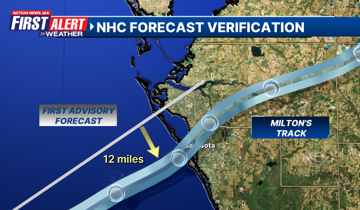
Remarkable accuracy by the Nat. Hurricane Center with the very first advisory issued Sat., Oct. 5th for Milton’s landfall 4 1/2 days later:


(1) “Leslie” was upgraded a week ago Wed. night & became a hurricane Fri. evening - the 8th of the Atlantic season & now exceeds the avg. for the entire season of 7 hurricanes. Leslie is weakening now & will stay well out to the east over the Central/NE Atlantic while turning sharply northeast then east.The 12th named storm develops - on avg. - Oct. 11th.

(2) A tropical wave - ‘L-94′ is moving off the coast of Africa with some potential for development but will quickly turn northwest so will stay over the far Eastern Atlantic.
(3) Another tropical wave is moving west off Africa at a lower latitude. This one has some potential next week while moving west across the Atlantic. It’s getting late in the season for an African wave to make it all the way across the Atlantic, but this one has a chance. A tropical cyclone may be approaching the NE Caribbean or SW Atlantic by next weekend but then moving into a generally hostile environment. It’s something to keep an eye on.
The GFS global model is very bullish on Caribbean tropical development with no other models onboard... at least yet. Such development would like move west into Central America... it would appear at this point. This season... the GFS has been decent on long range development while the European model has generally been slow to catch on until development becomes more obvious.
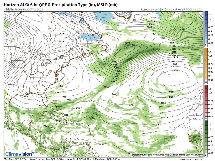
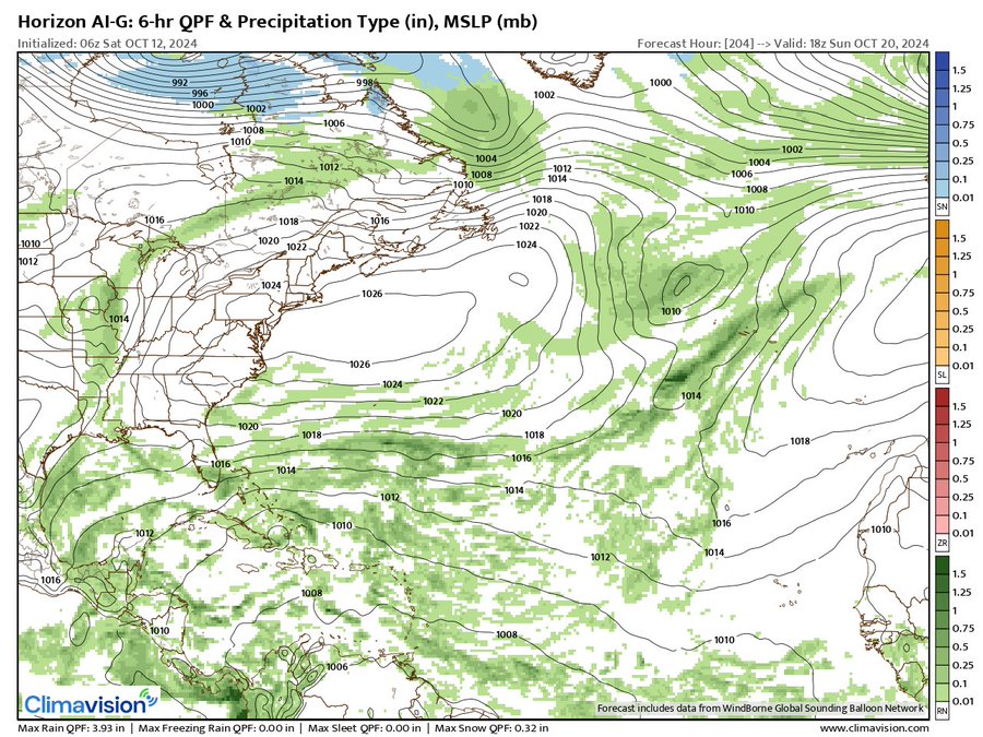
Climavision ‘HorizonAI’ global model is below & has been a good “steady eddy” & compromise between other models this season. The forecast map below is for early Fri., Oct. 18th showing a small tropical cyclone east/northeast of Puerto Rico that moves to near Cuba while weakening 2 days later early Sun., Oct. 20th:

‘Velocity potential anomalies’ below shows “sinking” air (brown lines) spreading across the Atlantic Basin. With sinking air, tropical development can occur but overall conditions are not as conducive as when there is overall rising (green lines) air where convection is active. An upward “pulse” over the Atlantic is due again by early Nov.

REMEMBER WHEN A TROPICAL STORM OR HURRICANE IS APPROACHING: Taping windows is *not* recommended & will not keep glass from breaking. Instead close curtains & blinds.
Realize the forecast cone (”cone of uncertainty”) is the average forecast error over a given time - out to 5 days - & *does not* indicate the width of the storm &/or where damage might occur.

The upper oceanic heat content (UOHC) [tropical cyclone heat potential/TCHP] across the SW Atlantic, Gulf & Caribbean is very high:


Water vapor loop (dark blue/yellow is dry mid & upper level air):


October tropical cyclone origins:

Averages below based on climatology for the Atlantic Basin for October:

Wind shear (red - strong shear; green - low shear):


Saharan dust spreads west each year from Africa driven by the prevailing winds (from east to west over the Atlantic). Dry air = yellow/orange/red/pink. Widespread dust is indicative of dry air that *can* interfere with the development of tropical cyclones. However, sometimes “wanna’ be” waves will just wait until they get to the other side of - or away from - the dust plume then try to develop if other conditions are favorable (we’ve already seen this with Beryl & Debby this year). In my personal opinion, there is way too much “hoopla” about the presence of Saharan dust & how it relates to tropical cyclones. In any case, the peak of Saharan dust typically is in June & July.

2024 names..... “Nadine” is the next name on the Atlantic list (names are picked at random by the World Meteorological Organization... repeat every 6 years). Historic storms are retired [Florence & Michael in ’18 (the last time this year’s list was used)... Dorian in ’19 & Laura, Eta & Iota in ‘20, Ida in ‘21 & Fiona & Ian in ‘22]). In fact, this year’s list of names is rather infamous because of the ‘04 season when Charley, Frances, Jeanne & Ivan - all retired names - hit Florida within a matter of about 6 weeks. The WMO decided - beginning in 2021 - that the Greek alphabet will be no longer used & instead there will be a supplemental list of names if the first list is exhausted (has only happened three times - 2005, 2020 & 2021). The naming of tropical cyclones began on a consistent basis in 1953. More on the history of naming tropical cyclones * here *.

Hurricane season climatology:


East Atlantic:


Mid & upper level wind shear (enemy of tropical cyclones) analysis (CIMMS). The red lines indicate strong shear:

Water vapor imagery (dark blue indicates dry air):

Deep oceanic heat content over the Gulf, Caribbean & deep tropical Atlantic. The colors will brighten greatly as the water warms to greater depths deeper into the season:

Sea surface temp. anomalies:


SE U.S. surface map:

Surface analysis centered on the tropical Atlantic:

Surface analysis of the Gulf:

Caribbean:

Atlantic Basin wave period forecast for 24, 48, 72 & 96 hours respectively:


East & Central Pacific:


Central Pacific:

Hawaii satellite imagery:


West Pacific:

Global tropical activity:


Cox Media Group


