
Jacksonville, Fl. — The “Buresh Bottom Line”: Always be prepared!.....First Alert Hurricane Preparation Guide... City of Jacksonville Preparedness Guide... Georgia Hurricane Guide.
STAY INFORMED: Get the * FREE * First Alert Weather app
FREE NEWS UPDATES, ALERTS: Action News Jax app for Apple | For Android
WATCH “Preparing for the Storm”
WATCH “The Ins & Outs of Hurricane Season”
READ the First Alert Hurricane Center “Preparation Guide”
Federal Alliance for Safe Homes (FLASH) * here *.
***** ALWAYS CHECK & RE-CHECK THE LATEST FORECAST & UPDATES! ****
Tropics threats for Jacksonville/NE Florida/SE Georgia: None though Monday... impacts late Tue. & especially Wed. into Thursday morning from “Milton”.
LOCAL IMPACTS FROM MILTON FOR JACKSONVILLE/NE FLORIDA & SE GEORGIA:
* There is still plenty of uncertainty in this forecast so impacts will be changing & will have to be amended/updated. The exact track will be critical for how much rain falls... there will be strong winds area wide but strongest over NE Fl. & the coast of SE Ga.
* I understand there are “scary” headlines & social media posts out there. I will remain constant, vigilant, responsible & as consistent as possible with the local impacts. There is no need to panic but checking & updating storm/hurricane preparedness kits & plans should be underway. If you live an evacuation zone & you become alerted to a ‘mandatory’ evacuation, the best advice is to ... EVACUATE. There will be decent weather Monday-Tuesday to continue preparations. Be sure to secure any & all objects that could be blown around by strong winds.
* AS OF RIGHT NOW... the greatest impacts to the local area would be *south & east of hardest hit areas from Helene* - the Lake City to Waycross corridor.
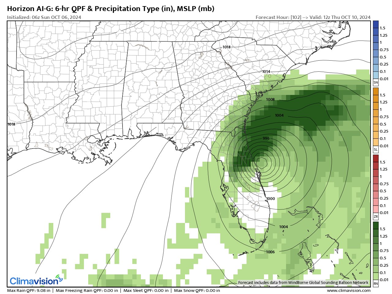
* RAIN heavy at times - not related to Milton - will occur across NE Fl. & SE Ga. through Sunday. This will sort of “set the table” for possible flooding when heavy rain from Milton reaches the local area by Tue. night into Wed. There is a lot of water in the “system”.... the ground is saturated... & flooding will easily occur during heavy rain. Amounts looks to average 1-2″, locally more through Sunday - heaviest Highway 301 to the coast. Rainfall amounts Tue.-Wed. look to be heaviest across NE Fl. & far SE Ga. & along the coast & could be 5″+ depending on exact track of Milton. Forecast models range widely on exact rainfall with some flip-flopping from one model run’s output to the next.
* WINDS will be breezy with onshore flow through Sunday into Monday & Tuesday. Then winds will increase markedly Tue.-Wed. into Thursday morning with the closest approach - wherever that is - of Milton. The exact magnitude of these winds is to still be determined. But trees will again be susceptible to being rather easily uprooted due to the saturated ground + some trees have been weakened by Helene’s winds last week. Sustained winds at tropical storm force - 40+ mph - appear likely for much of NE Florida with hurricane force - 75+ mph - gusts from I-95 to the beaches. Sustained winds 15-25mph for SE Ga. with gusts 35+ mph but along the Ga. coast sustained winds will be 25-35 mph with gusts 40-50+ mph. Wind direction will out of the east (onshore) through Wed. night then abruptly shift to more out of the northeast then north through the day Thursday. Due to the path offshore to the south of NE Fl, there will not be a nice offshore component to the winds following Milton.
* COAST: Milton looks very tough on the beaches with an extended period of onshore flow increasing in intensity each day through Wed. before becoming more parallel to the shore Thu./Fri. Expect heavy to possibly severe beach erosion & coastal flooding. Seas will easily be well into double digits... with breakers at the beaches of at least 10-15 feet. All mariners should plan to be ready to stay in port & to have things buttoned up - or evacuating &/or moving vessels to a safer port - by at least early Wed. (10/9).
* STORM SURGE: Preliminary storm surge is forecast to be 3-5 feet along the coast of Duval, St. Johns & Flagler Co.
* Minor FLOODING can be expected along the St. Johns River & its tributaries through Monday, especially at high tide.. then possibly at least moderate flooding Tue.-Wed. With all the rain expected to fall throughout Central Florida, flooding will continue along the St. Johns River & its tributaries - especially near high tide - for weeks.
* STORM SURGE potential is still to be determined but could be at least several feet - again depending on exact track & intensity of Milton. Highest - & possibly significant - storm surge will be in St. Johns Co. & points south reaching as far north - possibly as Duval Co. Again - DEPENDING ON EXACT TRACK of Milton.
* Isolated WATERSPOUTS & TORNADOES - low risk but some risk as bands northeast of the center rotate counterclockwise to the west & NW as Milton approaches then crosses Fl. Much higher tornado risk across Central & South Florida.
“Buresh Bottom Line”:
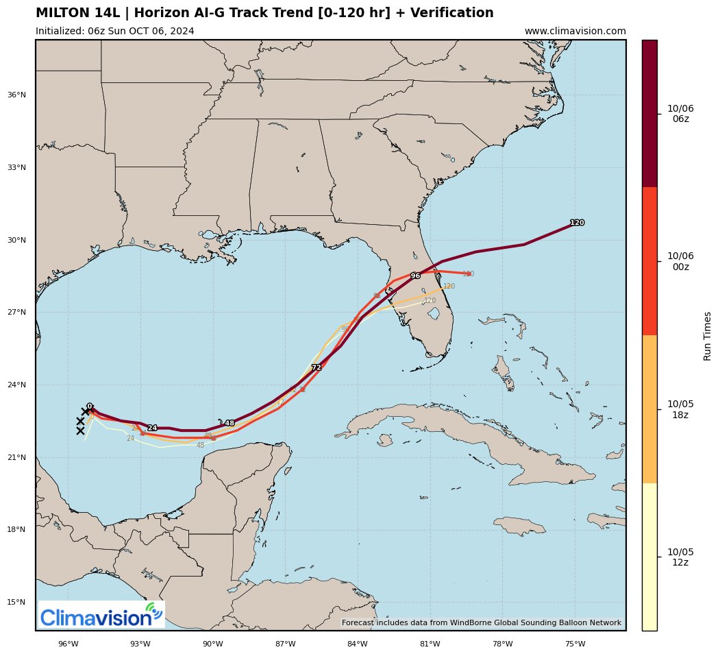
* Milton over the Western Gulf will move steadily east/northeast while strengthening with a Florida landfall Wed. (Oct. 9th) as a strong Cat. 3+ hurricane. This is a very high impact storm for most of Florida with the exception of far NW Fl. & the Panhandle. Remember that there WILL be changes in the forecast track &, therefore, impacts over the next couple days.
* “Kirk” & “Leslie” over the far Eastern Atlantic stay far to the east over the open Atlantic.
* “The Hell that was Helene” - Buresh Blog.
The Atlantic Basin Overview:
(1) Heads-up Florida - hurricane preparedness should be underway through Tuesday.
A Tropical Storm WARNING: Celestun to Cabo Catoche... A Tropical Storm WATCH: East of Cabo Catoche to Cancun.
* Forecast storm surge inundation interactive maps * here *.
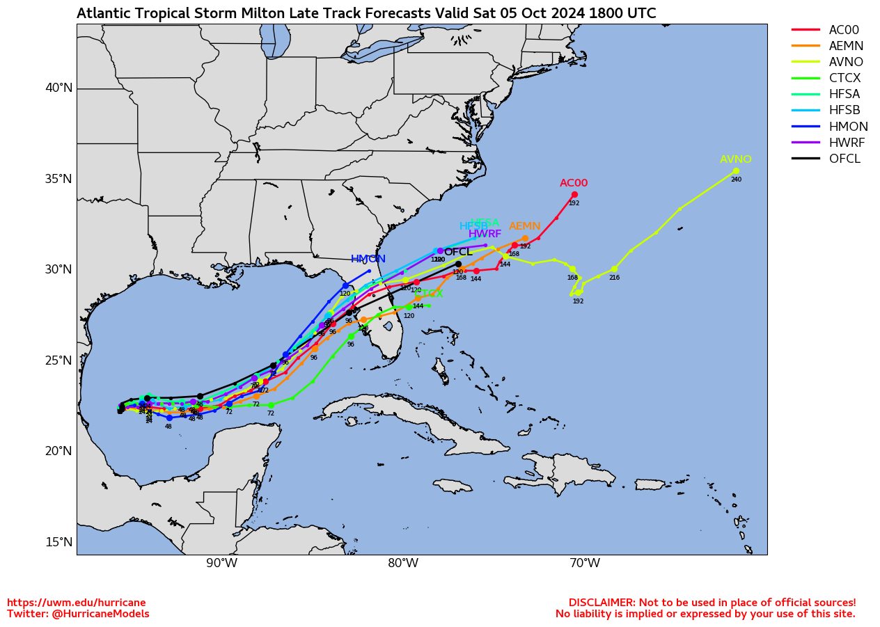
Low pressure became tropical depression #14 over the Western Gulf Sat. morning & was upgraded to tropical storm “Milton” Sat. afternoon - the 13th named storm of the Atlantic season... the avg. date for the 13th storm is Oct. 25th... & to the 9th hurricane of the Atlantic season Sunday afternoon which is already above the avg. for an entire season. There has been some shift to the southeast of a center that is pushing with strong convection & this jumping around of the center will continue until a cohesive core has formed ... which won’t be long given hurricane hunter aircraft has found a developing eye. Nonetheless, the more south center fix has caused an overall shift - especially early on - in the forecast track. THERE WILL CONTINUE TO BE CHANGES & UPDATES!
Forecast models are in good agreement & confidence is high on a strengthening hurricane hitting the west coast of Florida.... pretty evenly matched on timing - Wed. afternoon & night... but - very importantly - at different locations along the west coast. The GFS is the northern most global model - north of Tampa Bay Wed. evening... this would have much bigger implications for Jax/NE Fl. & would result in a severe storm surge into Tampa Bay. The European is just south of Tampa Bay & a little faster - Wed. afternoon... & would take the biggest impacts & heaviest rain south of Jacksonville but still heavy for St. Johns & Putnam Co. + wind for most of the area but especially NE Florida. The Canadian model remains the southern outlier - south of Ft. Myers & much slower - not ‘til early Friday - such a track would keep impacts far from Jacksonville. It does look like there may be a very sharp turn east at some point while crossing Florida. This abrupt turn east would have very big implications for direct impacts & their intensity for Jacksonville & NE Florida & is related to an upper level trough of low pressure over the Eastern U.S.
The Climavision ‘Horizon AI’ global model initiated a trend late Thu. to stronger & more north with a strong hurricane going over the top of Tampa Bay Wed. night. The ‘Horizon’ was quite good with Helene. The ‘Horizon’ has been reasonably steady from one model run to the next since Friday. One recent trend has been more of a bend to the east after landfall - so more of a due east, even slight E/SE movement once near Orlando & east. The map below shows the trend in the ‘Horizon’ since early Sat. morning:
Weak low pressure to the east of Milton will move across South Florida through Monday & may be interfering with model output for the moment & complicating the overall scenario with Milton. I also wonder about whether or not this lead weak low will be strong enough to nudge a front south some which would possibly then take Milton a *little* more south.
Nonetheless it does appear the west &/or SW coast of Fl. is line for a ‘major’ hurricane Wed./Wed. night, exiting the east coast of Fl. Thu. morning.
But beware! - this set-up remains in flux... AND regardless there is a consistent signal for very heavy rain & significant to major flooding for parts of Florida this weekend into next week particularly centered on Central & South Florida. Expect specific forecast details to ebb & flow at least through Monday until forecast models can resolve the details & interaction of the weak surface low, upper trough & Milton itself.
As for the upper level - 500mb/30,000 feet - trough of low pressure diving down into the Eastern U.S. - it will have a lot to do with where Milton will go & how it will track across Florida. If the trough axis is far enough east, Milton should get shunted more east with time which is what the models are occasionally catching on to but showing inconsistency on that turn more east. This turn is very, very critical for exact impacts. Confluent upper level flow on the backside of the trough should continue at least some shear near Florida as well as a vector pointing SE - both of which could be factors in the structure of the storm & where Milton moves. Bottom line is it’s still too early to determine exactly what exactly will come of Milton & where it might go.
But heads-up Florida!


It’s critical to realize the impacts - wind field including damaging winds & flooding - will extend far beyond the forecast cone of Milton!

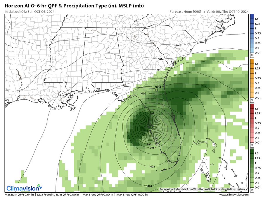
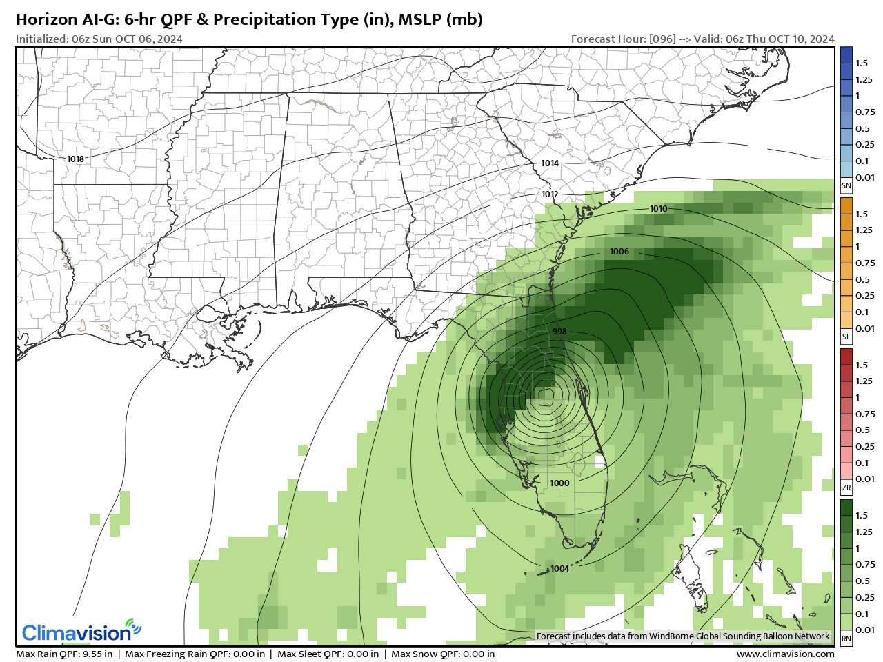
Climavision’s HorizonAI Global Model (this model uses its own data & analysis for initialization of each model run + some AI input) from 8pm Wed., Oct. 10 through 2am then 8am Thu., Oct. 11. Indicates an intense hurricane right over Tampa Bay - ~970mb/28.65″ or lower early Wed. evening followed by a turn more east along/near I-4 with an exit just north of Cape Canaveral & just south of Daytona Beach:
This is the ‘Horizon’ 500 mb (upper level) forecasts for early Wed., Oct 9th showing the trough over the Northeast U.S. with more of a “baggy” trough to the south interacting with “Milton”. This trough will impart some shear over/near Florida as well as a tendency to *possibly” suppress the tropical cyclone at least a little more south (vs. Gulf Coast).


Strong shear over Northern Gulf may tilt Milton at least some to the east. But Milton will moving in the direction of the shear vectors which may not hinder the storm as much as the magnitudes of 25+ mph typically might. Otherwise all other systems are “go” - warm to very warm water... lots of atmospheric moisture.
#firstalertwx considerations for #Milton - very warm water temps... warm deep oceanic heat content with very warm eddy E. Gulf... lots of moisture = favorable for strengthening... shear will increase with eastward extent but will be in line w/ forward movement so less detrimental pic.twitter.com/Ky3FSohWv2
— Mike Buresh (@MikeFirstAlert) October 5, 2024

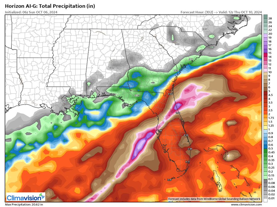
7-day forecast rainfall:


GFS 500mb - the persistent alleyway over the Central Atlantic looks like it stay intact effectively protecting the U.S. & Caribbean from Kirk, Leslie & a subsequent possible tropical cyclone over the Eastern Atlantic. A second alleyway exists from the Western Caribbean to Gulf which is why Caribbean/Gulf systems are a Florida/Southeast U.S. threat (Helene, Milton).

(2) “Kirk” has quickly strengthened over the Eastern Atlantic. Kirk became a hurricane Tue., the 7th of the Atlantic season which does not occur until Nov. 15th in an “average” season... & became a ‘major’ Cat. 3+ hurricane Thu. before now feeling the effects of cooler water & increasing shear. Kirk is already headed northward & will stay far away from the Caribbean or U.S. & far to the east of Bermuda. The Bermuda High remains weaker & displaced to the east/northeast allowing for a nice & early alleyway over the Central Atlantic which Eastern Atlantic tropical systems can follow keeping them far from any land areas & certainly well east of the Caribbean & U.S. The average date for the 11th named storm is Sept. 14th so nothing at all unusual right now vs. climatology when it comes to named storms vs. the avg. Atlantic hurricane season.
(3) Tropical depression #13 has formed right behind - to the east of - & was upgraded to “Leslie” Wed. night & became a hurricane Fri. evening - the 8th of the Atlantic season & now exceeds the avg. for the entire season of 7 hurricanes. Like Kirk, sister Leslie will stay well out to the east over the Central & Eastern Atlantic. The 12th named storm develops - on avg. - Oct. 11th.
Due to the intensity of the two storms, an easterly swell will emanate far to the west reaching the east coast through the upcoming week further enhancing the already high rip current risk at beaches along the east coast, Bermuda & the Caribbean.


‘Velocity potential anomalies’ below shows far less “sinking” air (brown lines) spreading across the Pacific Basin. With sinking air, tropical development can occur but overall conditions are not as conducive as when there is overall rising (green lines) air where convection is active. This “pulse” of upward motion has moved eastward & likely helped Helene & other Atlantic tropical cyclones & is past its peak. Milton managed to take advantage of the tail end of the “upward” pulse.

REMEMBER WHEN A TROPICAL STORM OR HURRICANE IS APPROACHING: Taping windows is *not* recommended & will not keep glass from breaking. Instead close curtains & blinds.
Realize the forecast cone (”cone of uncertainty”) is the average forecast error over a given time - out to 5 days - & *does not* indicate the width of the storm &/or where damage might occur.

The upper oceanic heat content (UOHC) [tropical cyclone heat potential/TCHP] across the SW Atlantic, Gulf & Caribbean is very high:


Water vapor loop (dark blue/yellow is dry mid & upper level air):


October tropical cyclone origins:

Averages below based on climatology for the Atlantic Basin for October:

Wind shear (red - strong shear; green - low shear):


Saharan dust spreads west each year from Africa driven by the prevailing winds (from east to west over the Atlantic). Dry air = yellow/orange/red/pink. Widespread dust is indicative of dry air that *can* interfere with the development of tropical cyclones. However, sometimes “wanna’ be” waves will just wait until they get to the other side of - or away from - the dust plume then try to develop if other conditions are favorable (we’ve already seen this with Beryl & Debby this year). In my personal opinion, there is way too much “hoopla” about the presence of Saharan dust & how it relates to tropical cyclones. In any case, the peak of Saharan dust typically is in June & July.

2024 names..... “Milton” is the next name on the Atlantic list (names are picked at random by the World Meteorological Organization... repeat every 6 years). Historic storms are retired [Florence & Michael in ’18 (the last time this year’s list was used)... Dorian in ’19 & Laura, Eta & Iota in ‘20, Ida in ‘21 & Fiona & Ian in ‘22]). In fact, this year’s list of names is rather infamous because of the ‘04 season when Charley, Frances, Jeanne & Ivan - all retired names - hit Florida within a matter of about 6 weeks. The WMO decided - beginning in 2021 - that the Greek alphabet will be no longer used & instead there will be a supplemental list of names if the first list is exhausted (has only happened three times - 2005, 2020 & 2021). The naming of tropical cyclones began on a consistent basis in 1953. More on the history of naming tropical cyclones * here *.

Hurricane season climatology:


East Atlantic:


Mid & upper level wind shear (enemy of tropical cyclones) analysis (CIMMS). The red lines indicate strong shear:

Water vapor imagery (dark blue indicates dry air):

Deep oceanic heat content over the Gulf, Caribbean & deep tropical Atlantic. The colors will brighten greatly as the water warms to greater depths deeper into the season:

Sea surface temp. anomalies:


SE U.S. surface map:

Surface analysis centered on the tropical Atlantic:

Surface analysis of the Gulf:

Caribbean:

Atlantic Basin wave period forecast for 24, 48, 72 & 96 hours respectively:


East & Central Pacific:


Central Pacific:

Hawaii satellite imagery:


West Pacific:

Global tropical activity:


Cox Media Group


