:quality(70)/cloudfront-us-east-1.images.arcpublishing.com/cmg/JIFG55NSN5HKZK6LKEZ4C7UU5I.jpg)
Jacksonville, Fl. — The “Buresh Bottom Line”: Always be prepared!.....First Alert Hurricane Preparation Guide... City of Jacksonville Preparedness Guide... Georgia Hurricane Guide.
STAY INFORMED: Get the * FREE * First Alert Weather app
FREE NEWS UPDATES, ALERTS: Action News Jax app for Apple | For Android
WATCH “Preparing for the Storm”
WATCH “The Ins & Outs of Hurricane Season”
READ the First Alert Hurricane Center “Preparation Guide”
Federal Alliance for Safe Homes (FLASH) * here *.
***** ALWAYS CHECK & RE-CHECK THE LATEST FORECAST & UPDATES! ****
Tropics threats for Jacksonville/NE Florida/SE Georgia: None.
“Buresh Bottom Line”:
* There is no named storm aimed at the U.S. this week!
* Short-lived “Nadine” has dissipated over Southern Mexico after moving ashore on the coast of Belize Saturday.
* Tropical wave - ‘95-L’ was upgraded to hurricane(!) “Oscar” near the SE Bahamas Sat. afternoon & made landfall on the eastern coast of Cuba Sunday night.
* “Mighty Milton” - Buresh Blog - recap of the hurricane including the forecast.
* “The Hell that was Helene” - Buresh Blog.
The Atlantic Basin Overview:
Neither Nadine or ‘94-L’ will impact Florida or any of the U.S.....
(1) Oscar is made landfall over the Southeast Bahamas & was upgraded Sat. morning to tropical storm “Oscar” - the 15th Atlantic storm & officially pushes the Atlantic season one named storm above the average for the entire season... then rapidly intensified into a hurricane by early Saturday afternoon, the 10th Atlantic hurricane this year - well above the average of 7 hurricanes per season. Oscar made landfall on the east coast of Cuba as a Cat. 1 hurricane late Sun. afternoon.
A Tropical Storm WARNING: North coast of the Cuban Provinces of Las Tunas, Holguin, and Guantanamo to Punta Maisi ... South coast of Cuban Province of Guantanamo ... Southeastern Bahamas
A Tropical Storm WATCH: Central Bahamas
Born from a wave that moved off the coast of Africa more than a week ago - impressive for mid October!, Oscar made landfall as a Cat. 1 hurricane on the east coast of Cuba a bit before 6pm EDT Sunday. Now inland, Oscar is weakening but will re-emerge off the northeast coast of Cuba by Mon. night. Strong wind shear & relatively dry air should keep Oscar “in check” despite moving over very warm water. Oscar will accelerate to the northeast through midweek eventually becoming absorbed by a large nontropical low over the Western Atlantic. Heavy rain & gusty winds for the Central & SE Bahamas Tue. then the remnants combined with the nontropical low will bring heavy rain & strong winds to Bermuda Wed.
Helping to “protect” the Lower 48 from Oscar is a strong upper level trough that’s driving a strong cold front deep into the Gulf & SW Atlantic which will induce the nontropical low over the Western Atlantic & help guide Oscar NE then more north & finally N/NW while merging with the low.
The ‘HorizonAI’ global model - the First Alert Weather Team is one of the few in the world with access to this model & a model that was pretty solid for Helene & Milton - was - like all the other global models - too weak with Oscar but has caught on now taking Oscar northeast from Cuba Mon. night then quickly across the SE Bahamas. Oscar remains a small tropical cyclone.


(2) Disturbance ‘95-L’/’Potential Tropical Cyclone Fifteen’ (PTC 15) was upgraded early Saturday to tropical storm “Nadine” over the Western Caribbean - the 14th named storm of the Atlantic season which in an “average” year occurs on Nov. 19th. Nadine is moving inland over Belize before managing to become much stronger.


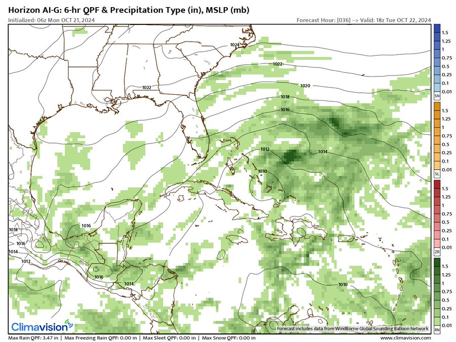
Climavision ‘HorizonAI’ global model is below & has been a good “steady eddy” & compromise between other models this hurricane season. The forecast map below is for Mon., Oct. 21st showing Oscar very weak after landfall on the coast of Cuba.
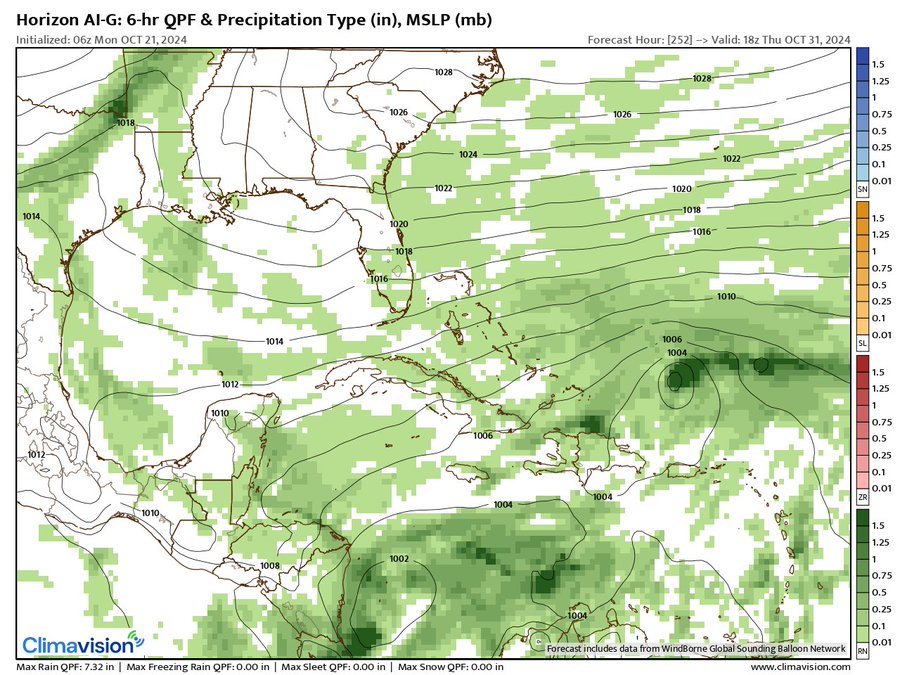
The ‘Horizon’ continues to develop a tropical cyclone over the Central Caribbean toward the end of the month - Thu., Oct. 31 - an area strongly favored late in the hurricane season... not to mention a “hot spot” this season.

‘Velocity potential anomalies’ below shows “sinking” air (brown lines) across the Atlantic Basin. With sinking air, tropical development can occur but overall conditions are not as conducive as when there is overall rising (green lines) air where convection is active. An upward “pulse” over the Atlantic is due again in Nov.

REMEMBER WHEN A TROPICAL STORM OR HURRICANE IS APPROACHING: Taping windows is *not* recommended & will not keep glass from breaking. Instead close curtains & blinds.
Realize the forecast cone (”cone of uncertainty”) is the average forecast error over a given time - out to 5 days - & *does not* indicate the width of the storm &/or where damage might occur.

The upper oceanic heat content (UOHC) [tropical cyclone heat potential/TCHP] across the SW Atlantic, Gulf & Caribbean is very high:


Water vapor loop (dark blue/yellow is dry mid & upper level air):


October tropical cyclone origins:

Averages below based on climatology for the Atlantic Basin for October:

Wind shear (red - strong shear; green - low shear):


Saharan dust spreads west each year from Africa driven by the prevailing winds (from east to west over the Atlantic). Dry air = yellow/orange/red/pink. Widespread dust is indicative of dry air that *can* interfere with the development of tropical cyclones. However, sometimes “wanna’ be” waves will just wait until they get to the other side of - or away from - the dust plume then try to develop if other conditions are favorable (we’ve already seen this with Beryl & Debby this year). In my personal opinion, there is way too much “hoopla” about the presence of Saharan dust & how it relates to tropical cyclones. In any case, the peak of Saharan dust typically is in June & July.

2024 names..... “Patty” is the next name on the Atlantic list (names are picked at random by the World Meteorological Organization... repeat every 6 years). Historic storms are retired [Florence & Michael in ’18 (the last time this year’s list was used)... Dorian in ’19 & Laura, Eta & Iota in ‘20, Ida in ‘21 & Fiona & Ian in ‘22]). In fact, this year’s list of names is rather infamous because of the ‘04 season when Charley, Frances, Jeanne & Ivan - all retired names - hit Florida within a matter of about 6 weeks. The WMO decided - beginning in 2021 - that the Greek alphabet will be no longer used & instead there will be a supplemental list of names if the first list is exhausted (has only happened three times - 2005, 2020 & 2021). The naming of tropical cyclones began on a consistent basis in 1953. More on the history of naming tropical cyclones * here *.

Hurricane season climatology:


East Atlantic:


Mid & upper level wind shear (enemy of tropical cyclones) analysis (CIMMS). The red lines indicate strong shear:

Water vapor imagery (dark blue indicates dry air):

Deep oceanic heat content over the Gulf, Caribbean & deep tropical Atlantic. The colors will brighten greatly as the water warms to greater depths deeper into the season:

Sea surface temp. anomalies:


SE U.S. surface map:

Surface analysis centered on the tropical Atlantic:

Surface analysis of the Gulf:

Caribbean:

Atlantic Basin wave period forecast for 24, 48, 72 & 96 hours respectively:


East & Central Pacific:


Central Pacific:

Hawaii satellite imagery:


West Pacific:


Global tropical activity:


Cox Media Group
:quality(70)/cloudfront-us-east-1.images.arcpublishing.com/cmg/JPAXNZHWSRGVHDYYH7MNGD4CYM.jpg)
:quality(70)/cloudfront-us-east-1.images.arcpublishing.com/cmg/OSMAZUJX6XJG33TBOWPJGJAU5A.jpg)
:quality(70)/cloudfront-us-east-1.images.arcpublishing.com/cmg/TICEDNDDORAD3EHPGVEXYLIA4Y.jpg)
:quality(70)/cloudfront-us-east-1.images.arcpublishing.com/cmg/ASUSVSHKB6WIU5J7D4Q56E4FIA.jpg)
:quality(70)/cloudfront-us-east-1.images.arcpublishing.com/cmg/URYYGKNTY5ETTAY5R47NF5SSOM.jpeg)