
Jacksonville, Fl. — The “Buresh Bottom Line”: Always be prepared!.....First Alert Hurricane Survival Guide... City of Jacksonville Preparedness Guide... Georgia Hurricane Guide.
STAY INFORMED: Get the * FREE * First Alert Weather app
FREE NEWS UPDATES, ALERTS: Action News Jax app for Apple | For Android
WATCH “The Ins & Outs of Hurricane Season”
WATCH “Preparing for the Storm”
READ the First Alert Hurricane Center “Survival Guide”
***** ALWAYS CHECK & RE-CHECK THE LATEST FORECAST & UPDATES! *****
Elsa & local impacts:
* Over the SE & Eastern Gulf through Tue. then NW/N. Central Fl. Wed, into Ga. & through the coastal Carolina’s Thursday
* Jacksonville/NE Fl./SE Ga. impacts look to be centered on Tue. night/Wed. - heavy rain at times, some flooding, gusty winds & isolated tornadoes possible along with rough seas & surf at our beaches. This does not look to be a “major” hit on the local area or any of Fl. but changes are still possible! And remember there’s not such thing as “just a” as tropical storms can cause damage & injury too. Respect the weather!
* Given the current forecast, winds Wed. will average 20-30 mph with gusts 40+ mph. Sustained winds may approach or even reach 40 mph for a time from Gainesville to Sanderson & Lake City to Waycross, Blackshear & Nahunta. Saturated soil from the recent wet weeks will mean some trees will be more easily uprooted.
* Storm surge - based on a weakening storm west of Jacksonville - will not be significant along the east coast/intracoastal & for the beaches. There will be some storm surge along the St. Johns River & its tributaries, but the magnitude does not appear to be very significant (less than 2 feet). Still - there will be a lot of water in the river system & there will be a pretty strong push of southerly winds Wed. to the east of Elsa’s center. So there will at least some flooding threat along Black Creek & the St. Johns River & its tributaries, the extent of which does not *appear* to be severe right now. Since Black Creek is a smaller river, it - like several tributaries - will be more subject to quick rises due to heavy rain. So if you’re in a flood prone area, stay aware of rainfall forecasts & any flood warnings that might be issued.
* Rainfall from Elsa will average 1-2″ from the storm but as much as 3″+ locally (some places have had that much from our afternoon thunderstorms in recent days!)
* Bridges should be able to remain open for the most part (usually close when sustained winds are 40+ mph).... a few sporadic power outages will be possible... businesses should either be able to remain open or at least quickly re-open following Elsa’s impacts... & overall infrastructure should remain in good shape during & after Elsa’s passage. JIA is likely to be able to remain open through the storm though individual flights in or out may be delayed or even cancelled.
* over the next several days don’t lose track of this tropical system - continue to get updated forecasts each day.
What was a strong tropical wave speeding west/northwest over the Central Atlantic was upgraded to t.d. #5 late Wed. evening & tropical storm “Elsa” early Thursday & now - early Fri. - a hurricane while moving over Barbados then back to a tropical storm Sat. This is the fastest ever to the 5th storm beating the old record of “Edouard” on July 6th, 2020.... the farthest east that a hurricane has formed since the infamous 1933 season... & well ahead of the avg. first Atlantic hurricane of Aug. 14th. Elsa weakened back down to a tropical storm Sat. as the center moved just south of the coast of Haiti.
The storm has been making the turn more northwest. Elsa’s convection has been bursting causing the center to jump around some - a combination of moderate shear + interaction with land has made for some interference with the overall organization. But there have some occasional indications - Sat. night & again Sunday night - of some intensification with decent banding, bursts of t’storms & lightning near the center. It appears Elsa has now indeed reached the western edge of the sprawling Bermuda High. This set-up will push Elsa NW early Tue. followed by a turn to the north over the Eastern Gulf. The turn north & northeast is being dictated by the strength & positioning of the Bermuda High east of Florida while a rather strong upper level trough quickly swings east over the Eastern U.S. then lifts north/northeast over the NW Atlantic. A small upper level trough over the Gulf will also help in steering Elsa northward.
Forecast models remain in generally better agreement. As a whole, the modeling has trended west & now stabilized near the official NHC forecast. One has to give the nod to the GFS at this point given that model has been strongest & the most west followed by the current trend of weakening while turning northwest then some more organizing while moving north over the Eastern Gulf. The American GFS model has been steady since at least midweek with a pretty well developed, sometimes even strong tropical cyclone that crosses Cuba then moves into the far Southeast Gulf while turning northward & eventually into or near Florida while weakening. It is worth noting that the GFS model was tweaked during the offseason because of the model missed several developing tropical cyclones last year. The GFS now shows little more than a relatively weak tropical cyclone - weak to moderate tropical storm - while crossing Florida, a depression once in Georgia.
The European model had been having a tough time “finding” the wave that’s become Elsa... then tried to take the storm east of Florida but has been trending better recently & has finally seems to be in the “game”. The model has been variable on intensity & now is one of the stronger models - a solidly moderate but compact tropical storm - showing Elsa moving north/northeast across NW Florida Wed. - pretty close to the GFS track.
The UKMET model - has not initialized a strong enough storm & has jumped around a lot over the past week. The model seems to have now locked in on Elsa & is very similar to the GFS & European.
It’s noteworthy that there is a warm eddy of water over the SE Gulf (image below) but a little west of the projected track. Sea surface temps., on the other hand, are actually a bit below avg. There will also be at least moderate shear through midweek in the path of Elsa not to mention the recent land interaction with the Greater Antilles. Given the fragile structure & small core of Elsa, the storm will likely be very sensitive to small changes in the overall environment (whether it’s land interaction or meteorological) & so we may see sudden increases or decreases in the storm’s intensity up to landfall.
Outer bands will impact the Keys & far south Florida spreading north & becoming more significant Tue.-Wed. Conditions will quickly improve across Fl. by Thu. as Elsa accelerates northeast across the Carolina’s then offshore just off the U.S. coast over the NW Altantic through late Fri. This does not look like a “big” hit on Fl. but realize there will be some storm surge on the west coast, gusty winds, heavy rain & isolated tornadoes throughout a good part of Fl. - any or all of which can do damage.
So don’t let your guard down! Check in for updated forecasts over the next several days & realize there is still a certain amount of uncertainty..... as with any meteorological forecasting(!).

Elsewhere... No other areas of genuine tropical concern right now across the Atlantic Basin.


Elsa spaghetti plots:


Saharan dust. Dry air - yellow/orange/red/pink - is extensive over the Central & Eastern Atlantic. Such widespread dust is common early in the hurricane season:

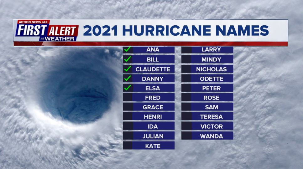
2021 names..... “Fred” is the next name on the Atlantic list (names are picked at random by the World Meteorological Organization... repeat every 6 years... historic storms are retired (Florence & Michael in ’18... Dorian in ’19 & Laura, Eta & Iota in ‘20). Last year - 2020 - had a record 30 named storms. The WMO decided beginning in 2021 that the Greek alphabet will be no longer used & instead there will be a supplemental list of names if the first list is exhausted (has only happened twice - 2005 & 2020). More on the history of naming tropical cyclones * here *.


East Atlantic:


Mid & upper level wind shear (enemy of tropical cyclones) analysis (CIMMS). The red lines indicate strong shear which is widespread from the Gulf of Mexico & Caribbean eastward across much of the Atlantic:

Water vapor imagery (dark blue indicates dry air):

Deep oceanic heat content is slowly increasing across the SE Gulf, Caribbean & deep tropical Atlantic:

Sea surface temp. anomalies:


SE U.S. surface map:

Surface analysis centered on the tropical Atlantic:

Surface analysis of the Gulf:

Caribbean:

Atlantic Basin wave forecast for 24, 48 & 72 hours respectively:


Global tropical activity:


Cox Media Group


