Jacksonville, Fl. — The “Buresh Bottom Line”: Always be prepared!.....First Alert Hurricane Preparation Guide... City of Jacksonville Preparedness Guide... Georgia Hurricane Guide.
STAY INFORMED: Get the * FREE * First Alert Weather app
FREE NEWS UPDATES, ALERTS: Action News Jax app for Apple | For Android
WATCH “Preparing for the Storm”
WATCH “The Ins & Outs of Hurricane Season”
READ the First Alert Hurricane Center “Preparation Guide”
***** ALWAYS CHECK & RE-CHECK THE LATEST FORECAST & UPDATES! *****
REMEMBER WHEN A TROPICAL STORM OR HURRICANE IS APPROACHING: Taping windows is *not* recommended & will not keep glass from breaking. Instead close curtains & blinds.
Realize the forecast cone (”cone of uncertainty”) is the average forecast error over a given time - out to 5 days - & *does not* indicate the width of the storm &/or where damage might occur.

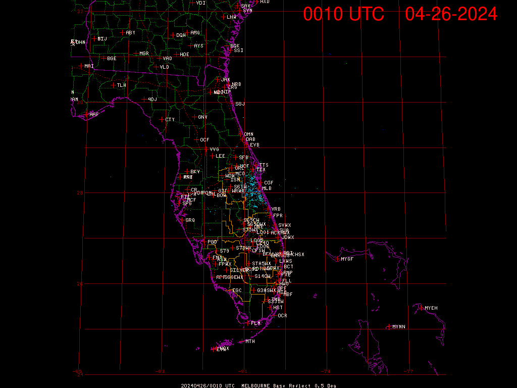
*** LOCAL (Jacksonville/NE Fl./SE Ga.) IMPACTS FROM THE TROPICS: The approaching disturbance from the Atlantic will continue to cause gusty winds, rip currents & bands/clusters of heavy rain, a few t’storms. The peak impacts will be through Friday evening with breakers at the beaches as high as 4-6 feet.
The Atlantic Basin Overview:
(1) an upper level trough over the Central/SW Atlantic has left behind a “piece” of the trough. A small low pressure area - ‘92-L’ - has developed beneath the persistent but disorganized showers & t’storms to the east/northeast of the Bahamas. Forecast models have come into decent agreement that strong surface development will be hard to come by given a good deal of surrounding dry air though wind shear has decreased vs. previous days. It continues to look like a surface trough of low pressure arriving at the Southeast U.S. coast stretched out from the Carolina’s to Florida by Friday with the weak surface low moving ashore somewhere not too far from Jacksonville. The low will cross the gulf stream tonight/early Friday, so we might see a better organization during this time. The expectation is for bands of heavy showers/a few t’storms, gusty winds & a high rip current risk at the beaches that will be most enhanced Thu. night through Friday into Fri. evening before subsiding over the weekend.
“Buresh Bottom Line”: there will be an uptick - a much needed one - in rainfall for NE Fl./SE Ga. through Friday night though amounts don’t look to be excessive, especially considering the recent very dry conditions. The heaviest rain will most likely occur near & north of the low pressure area & may be as much as 1-2″, locally more. The surface/tropical development with this system should be gradual & remain quite disorganized. There will be gusty onshore flow resulting in rough seas/surf & a high rip current risk at area beaches. Swim & surf with a buddy & as close to a lifeguard as at all possible.

Radar imagery from South Florida Water Management District:


NE Fl./SE Ga. rainfall forecast for the 48 hours:


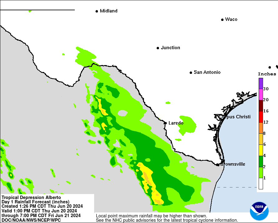
(2) The broad low pressure over the Bay of Campeche finally got its act together & was upgraded Wed. morning to the first Atlantic named storm of the season - “Alberto”. The most significant impacts have been & - will be - very heavy rain & flooding for Mexico extending northward into South Texas where rainfall may exceed 10″ though this is also an area suffering from drought so a certain amount of the rain will be welcome. Gusty winds & rough seas/surf extend far to the north of the poorly organized system all the way to the Texas coast.
Landfall was Thursday morning & Alberto will now rapidly weaken over land.
Bottom line: no local impacts from the Gulf disturbance for Jacksonville or any of Florida. But there will be a significant flooding & mudslides across Northeast & Eastern Mexico.
(3) A third area of low pressure may develop over the weekend into early next week over the Southern & Western Gulf of Mexico pretty close to where Alberto traversed. With upper level high pressure remaining across the Central & Eastern U.S., this low - if it develops - would most likely stay over the Western Gulf & gradually get pushed more west with time - again into Mexico.


The upper oceanic heat content (UOHC) [tropical cyclone heat potential/TCHP] across the SW Atlantic, Gulf & Caribbean is unseasonably high for this time of year:


Water vapor loop (dark blue/yellow is dry mid & upper level air):


June tropical cyclone origins (early season breeding grounds are the Gulf &/or Western Caribbean:

Averages below based on climatology for the Atlantic Basin for November (7 hurricanes so far, 19 tropical storms):
Wind shear (red - strong shear; green - low shear):


Saharan dust spreads west each year from Africa driven by the prevailing winds (from east to west over the Atlantic). Dry air = yellow/orange/red/pink. Widespread dust is indicative of dry air that *can* interfere with the development of tropical cyclones. However, sometimes “wanna’ be” waves will just wait until they get to the other side of - or away from - the dust plume then try to develop if other conditions are favorable. In my personal opinion, there is way too much “hoopla” about the presence of Saharan dust & how it relates to tropical cyclones. In any case, the peak of Saharan dust typically is in June & July.

2024 names..... “Beryl” is the first name on the Atlantic list (names are picked at random by the World Meteorological Organization... repeat every 6 years). Historic storms are retired [Florence & Michael in ’18 (the last time this year’s list was used)... Dorian in ’19 & Laura, Eta & Iota in ‘20, Ida in ‘21 & Fiona & Ian in ‘22]). In fact, this year’s list of names is rather infamous because of the ‘04 season when Charley, Frances, Jeanne & Ivan - all retired names - hit Florida within a matter of about 6 weeks. The WMO decided - beginning in 2021 - that the Greek alphabet will be no longer used & instead there will be a supplemental list of names if the first list is exhausted (has only happened three times - 2005, 2020 & 2021). The naming of tropical cyclones began on a consistent basis in 1953. More on the history of naming tropical cyclones * here *.


East Atlantic:


Mid & upper level wind shear (enemy of tropical cyclones) analysis (CIMMS). The red lines indicate strong shear:

Water vapor imagery (dark blue indicates dry air):

Deep oceanic heat content over the Gulf, Caribbean & deep tropical Atlantic. The colors will brighten greatly as the water warms to greater depths deeper into the season:

Sea surface temp. anomalies:


SE U.S. surface map:

Surface analysis centered on the tropical Atlantic:

Surface analysis of the Gulf:

Caribbean:

Atlantic Basin wave period forecast for 24, 48, 72 & 96 hours respectively:


East & Central Pacific:


West Pacific:

Global tropical activity:


Cox Media Group