:quality(70)/cloudfront-us-east-1.images.arcpublishing.com/cmg/JIFG55NSN5HKZK6LKEZ4C7UU5I.jpg)
Jacksonville, Fl. — The “Buresh Bottom Line”: Always be prepared!.....First Alert Hurricane Preparation Guide... City of Jacksonville Preparedness Guide... Georgia Hurricane Guide.
STAY INFORMED: Get the * FREE * First Alert Weather app
FREE NEWS UPDATES, ALERTS: Action News Jax app for Apple | For Android
WATCH “Preparing for the Storm”
WATCH “The Ins & Outs of Hurricane Season”
READ the First Alert Hurricane Center “Preparation Guide”
***** ALWAYS CHECK & RE-CHECK THE LATEST FORECAST & UPDATES! *****
*** LOCAL (Jacksonville/NE Fl./SE Ga.) IMPACTS FROM THE TROPICS: None
The Atlantic Basin Overview:
(1) The strong tropical wave - ‘95-L’ - that moved off the coast of Africa June 25 took just 13 days to move across the Atlantic, Caribbean & Gulf of Mexico before a U.S. landfall. The wave was upgraded to tropical depression #2 Friday afternoon, June 28 ... tropical storm Beryl Friday evening... & the first hurricane of the Atlantic season Sat. afternoon, June 29 becoming a ‘major’ Cat. 3 early Sunday, July 1 then a Cat. 5 late Mon. evening, July 2nd. Beryl’s third landfall (1st in Windward Islands/Cat. 4, 2nd south coast of Jamaica/Cat. 3) was just northeast of Tulum, Mexico on the Yucatan Peninsula about 7am EDT Fri. as a Cat. 2... & slowly reorganized becoming a hurricane again near midnight Sunday before a Cat. 1 landfall near 4am Monday at Matagorda, Texas or 85 miles south/southwest of Houston.
Beryl has been shattering the early season record books... from Dr. Phil Klotzbach:
Intensity Measures
- 165 mph (Category 5) lifetime maximum sustained winds – strongest maximum sustained winds for an Atlantic hurricane prior to August on record. Old record (Emily, 2005 – 160 mph – also a Category 5).
- 934 hPa lifetime minimum central pressure – 3rd lowest central pressure for an Atlantic hurricane prior to August on record. Trailing (Emily, 2005 – 929 hPa and Dennis, 2005 – 930 hPa). - Earliest Atlantic Category 4 hurricane on record (30 June at 18 UTC). Old record was Dennis (8 July 2005 at 0 UTC).
- Earliest Atlantic Category 5 hurricane on record (2 July at 3 UTC). Old record was Emily (17 July 2005 at 0 UTC).
- Beryl became a hurricane at 49.3°W – the farthest east an Atlantic hurricane had formed in the tropics (south of 23.5°N) in June on record. Old record was Cuba/Brownsville of 1933 (59°W).
- 65 mph/24 hr intensification rate from 29 June – 30 June – the fastest 24 hr intensification rate for an Atlantic named storm this early in the calendar year on record. Previous earliest 65 mph/24 hr intensification rate was Bertha (2008) from 6 July – 7 July.
- ~35 Accumulated Cyclone Energy (ACE) – the most ACE by a single Atlantic storm getting named prior to 1 August on record. Old record was Emily (2005 – ~33 ACE).
- 4.5 major (Category 3+) hurricane days – the most for a storm getting named prior to 1 August on record. Old record was Emily (2005 – 4.25 major hurricane days).
- 9.75 named storm days – 6th most for a storm getting named prior to 1 August on record.
- 6.25 hurricane days – 7th most for a storm getting named prior to 1 August on record.
Landfalls - Carriacou Island, Grenada: 150 mph, 950 hPa – Category 4 (1 July, 1510 UTC) - Strongest hurricane on record to make landfall in Grenada. Hurricane Ivan (2004) did not officially make landfall on Grenada but passed ~10 miles south of the main island of Grenada with maximum winds estimated at 125 mph, damaging 90% of the homes on the island
- Quintana Roo, Mexico: 110 mph, 975 hPa – Category 2 (5 July, 1105 UTC) - First Category 2+ hurricane to make landfall in Quintana Roo in July since Emily (2005) (Category 4, 130 mph)
- Matagorda, Texas: 80 mph, 979 hPa – Category 1 (8 July, 9 UTC) - Earliest calendar year hurricane landfall in Texas since Bonnie (26 June 1986) - 10th hurricane to make landfall in Texas in July on record and the first since Hanna (2020
Beryl exited the Yucatan Peninsula late Friday - as a tropical storm moving over the Western Gulf of Mexico while turning more northward trying to ward off dry air & shear. Beryl lost much of its core, so it took a while to reorganize & had a broad 28 mile wide eye at landfall.
An upper level high remains the main steering current. As this ridge split, “Beryl” is gained more latitude. In general, the split of the ridge - one center over Jacksonville, FL & another, stronger center over the Western U.S. carves out a “softness” or alleyway over the Western Gulf also helped out by a trough of low pressure moving across northern latitudes. So the ridge to the east & the trough to the north guided Beryl over the Western Gulf & then into Texas with a bend now to the northeast over Texas while weakening over land. Rainfall will be very heavy for a time with amounts up to a foot, even 15″, but Beryl will at least be progressive, so it will not be a repeat for Texas of “Harvey” in 2017.
Isolated tornadoes will occur all along & to the immediate east & southeast of the track of Beryl from Texas Monday-Mon. night to the Ohio Valley by Tue. night/Wed.


Morphed Integrated Microwave Imagery’s from CIMSS (fascinating!):
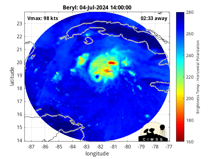
From CIRA (CSU):


More than half a foot of rain for South Texas over the next 5 days:

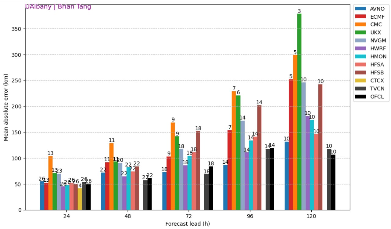
Through late Friday - one week since the birth of Beryl, the GFS (American) model has been best... the NHC has consistently beaten all the modeling(!):
An aside: “Beryl” was an early season storm back in 2012 coming ashore in Duval Co. & metro Jacksonville, Florida just below hurricane strength during the weekend of Memorial Day.
:quality(70)/pbs.twimg.com/media/DeFjqSWW4AAIE7m.jpg)
(2) A next tropical wave - ‘96-L’ - came off the coast of Africa last weekend following in the footsteps of Beryl but conditions have been far less favorable. This wave is still evident in satellite imagery over the far Western Caribbean. With land interaction imminent, any development will have to wait until it crosses Central America & Mexico to the East Pacific.
(3) An upper level low is producing a good deal of convection about midway between Jacksonville & Bermuda. If a surface low can become established underneath the convection, this could be an area to keep an eye on. Forecast models, however, are showing little development at the moment.
“Buresh Bottom Line”: * Beryl will weaken while continuing to move inland with a turn more northeast. Heavy rain, strong winds & a tornado threat will accompany even the remnants of Beryl to the northeast through midweek.


REMEMBER WHEN A TROPICAL STORM OR HURRICANE IS APPROACHING: Taping windows is *not* recommended & will not keep glass from breaking. Instead close curtains & blinds.
Realize the forecast cone (”cone of uncertainty”) is the average forecast error over a given time - out to 5 days - & *does not* indicate the width of the storm &/or where damage might occur.


The upper oceanic heat content (UOHC) [tropical cyclone heat potential/TCHP] across the SW Atlantic, Gulf & Caribbean is unseasonably high for this time of year:


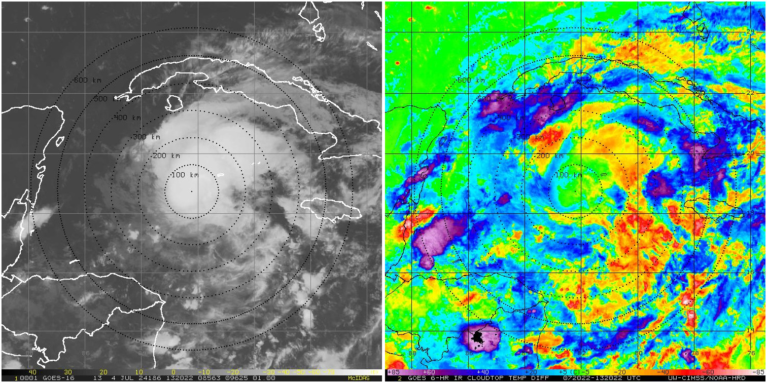
Water vapor loop (dark blue/yellow is dry mid & upper level air):


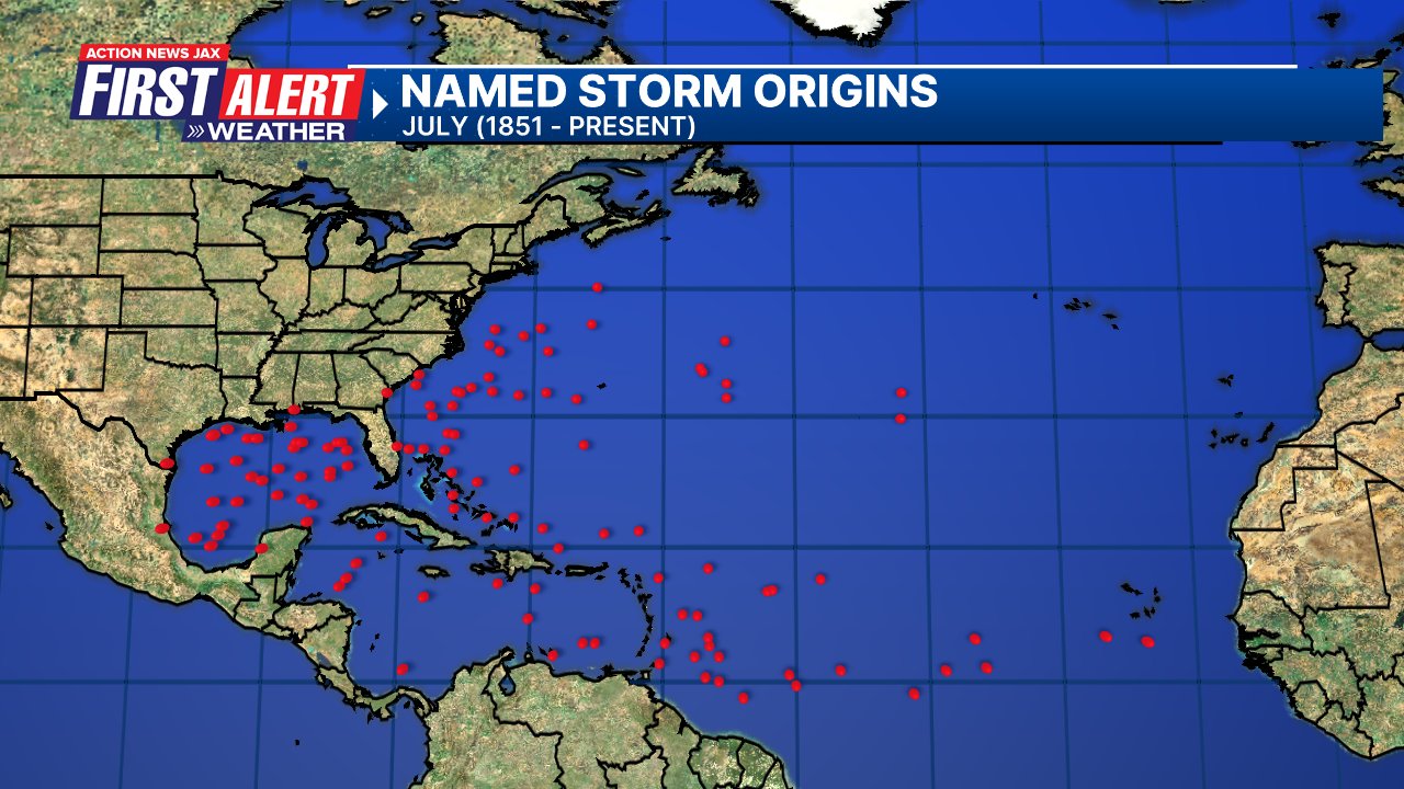
July tropical cyclone origins (early season breeding grounds are the Gulf &/or Western Caribbean:
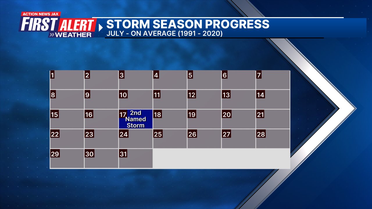
Averages below based on climatology for the Atlantic Basin for July (1 hurricane so far, 3 tropical storms):
Wind shear (red - strong shear; green - low shear):


Saharan dust spreads west each year from Africa driven by the prevailing winds (from east to west over the Atlantic). Dry air = yellow/orange/red/pink. Widespread dust is indicative of dry air that *can* interfere with the development of tropical cyclones. However, sometimes “wanna’ be” waves will just wait until they get to the other side of - or away from - the dust plume then try to develop if other conditions are favorable. In my personal opinion, there is way too much “hoopla” about the presence of Saharan dust & how it relates to tropical cyclones. In any case, the peak of Saharan dust typically is in June & July.

2024 names..... “Debby” is the next name on the Atlantic list (names are picked at random by the World Meteorological Organization... repeat every 6 years). Historic storms are retired [Florence & Michael in ’18 (the last time this year’s list was used)... Dorian in ’19 & Laura, Eta & Iota in ‘20, Ida in ‘21 & Fiona & Ian in ‘22]). In fact, this year’s list of names is rather infamous because of the ‘04 season when Charley, Frances, Jeanne & Ivan - all retired names - hit Florida within a matter of about 6 weeks. The WMO decided - beginning in 2021 - that the Greek alphabet will be no longer used & instead there will be a supplemental list of names if the first list is exhausted (has only happened three times - 2005, 2020 & 2021). The naming of tropical cyclones began on a consistent basis in 1953. More on the history of naming tropical cyclones * here *.


East Atlantic:


Mid & upper level wind shear (enemy of tropical cyclones) analysis (CIMMS). The red lines indicate strong shear:

Water vapor imagery (dark blue indicates dry air):

Deep oceanic heat content over the Gulf, Caribbean & deep tropical Atlantic. The colors will brighten greatly as the water warms to greater depths deeper into the season:

Sea surface temp. anomalies:


SE U.S. surface map:

Surface analysis centered on the tropical Atlantic:

Surface analysis of the Gulf:

Caribbean:

Atlantic Basin wave period forecast for 24, 48, 72 & 96 hours respectively:


East & Central Pacific:
A tropical storm - Aleta - finally developed over the E. Pacific July 4th - the latest on record (of the satellite era). The storm lasted little more than 24 hours & has dissipated.


West Pacific:

Global tropical activity:


Cox Media Group
:quality(70)/cloudfront-us-east-1.images.arcpublishing.com/cmg/2XJTOA6QV5EFPHGUEXNOY6IIJE.jpg)
:quality(70)/cloudfront-us-east-1.images.arcpublishing.com/cmg/CQJQAW36I5FPHEOCYBCFEHSJME.jpg)
:quality(70)/cloudfront-us-east-1.images.arcpublishing.com/cmg/JIFG55NSN5HKZK6LKEZ4C7UU5I.jpg)
:quality(70)/d1hfln2sfez66z.cloudfront.net/10-05-2024/t_b60825459bee4e3aa3b4f6b3368dc55d_name_file_960x540_1200_v3_1_.jpg)
:quality(70)/cloudfront-us-east-1.images.arcpublishing.com/cmg/ZOSLCTQ3WCBDEHF5W5UYWYWSZA.jpg)