:quality(70)/cloudfront-us-east-1.images.arcpublishing.com/cmg/JIFG55NSN5HKZK6LKEZ4C7UU5I.jpg)
Jacksonville, Fl. — The “Buresh Bottom Line”: Always be prepared!.....First Alert Hurricane Preparation Guide... City of Jacksonville Preparedness Guide... Georgia Hurricane Guide.
STAY INFORMED: Get the * FREE * First Alert Weather app
FREE NEWS UPDATES, ALERTS: Action News Jax app for Apple | For Android
WATCH “Preparing for the Storm”
WATCH “The Ins & Outs of Hurricane Season”
READ the First Alert Hurricane Center “Preparation Guide”
***** ALWAYS CHECK & RE-CHECK THE LATEST FORECAST & UPDATES! *****
*** LOCAL (Jacksonville/NE Fl./SE Ga.) IMPACTS FROM THE TROPICS: None
The Atlantic Basin Overview:
(1) A Tropical Storm WARNING: The coast of the Yucatan Peninsula of Mexico west of Cabo Catoche to Campeche
The strong tropical wave - ‘95-L’ - that moved off the coast of Africa early last week has been rolling west/W/NW & was upgraded to tropical depression #2 Friday afternoon ... tropical storm Beryl Friday evening... & the first hurricane of the Atlantic season Sat. afternoon becoming a ‘major’ Cat. 3 early Sunday then a Cat. 5 late Mon. evening. Beryl’s third landfall (1st in Windward Islands/Cat. 4, 2nd south coast of Jamaica/Cat. 3) was just northeast of Tulum, Mexico on the Yucatan Peninsula about 7am EDT Fri. as a Cat. 2. The transit over land weakened Beryl to a tropical storm Fri. afternoon.
Beryl has been shattering the early season record books:
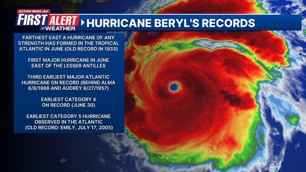
Beryl underwent an eyewall replacement cycle - typical for strong hurricanes - Sunday night. Once completed, Beryl intensified quickly again. Another eyewall replacement cycle (the main eye gives way to a new outer eye that eventually takes over) took place Tue. afternoon + increasing mid & upper level wind shear to the immediate west has allowed Beryl to come down from its peak. The W/SW shear has opened up the south & southwest portion of the eyewall since Wed. evening. Interaction with Jamaica’s mountainous terrain caused additional weakening. This is only the third Cat. 3 or stronger hurricane to pass within 50 miles of Jamaica during the month of July & the strongest direct hurricane hit on Jamaica since “Dean” in 2007. Beryl has been a resilient tropical cyclone despite fairly strong westerly & now southerly shear regaining Cat. 3 strength Thu. evening before leveling off & weakening some upon the Yucatan landfall.
The track for Beryl becomes more fuzzy now vs. the straight forward track of the past week or so thanks to a rock solid upper level ridge of high pressure that had been sprawled out across the U.S. into the Atlantic finally breaking down & shifting.
No impact to Jacksonville or Florida. Beryl will exit the Yucatan Peninsula by late Friday - likely as a tropical storm then it’s onto the Bay of Campeche/Western Gulf of Mexico through the weekend - sort of a tropical cyclone hangout this season so far. Land interaction will greatly weaken Beryl but there should be enough of a core left to allow reorganization over the weekend though that rejuvenation process will likely take a while. But Beryl has been an over-achiever so far, so we’ll see how long that reorganization takes. In addition, the shear will be more in line with Beryl’s movement (from the south/SW) which may be less detrimental to its intensity... we may also see the center reform - or jump around - as Beryl tries to reorganize.
In any case... the Yucatan looks to be a fork in the road for the longer term track thanks to repositioning of the upper level ridge to the north, so South Texas remains a possible “landing spot”... by Monday. The exact track & intensity is problematic & highly uncertain due to the land interaction & positioning of the upper level ridge. The overall model trends have come into pretty good agreement across the board, but all of the models have bounced around a great deal on long term intensity. Overall conditions - less shear, some upper level ventilation it would appear + very warm ocean water = potential for a stronger Beryl yet again by late in the weekend into early next week. In fact, some forecast models show yet another rapid intensification (IR) cycle upon approach to the land.
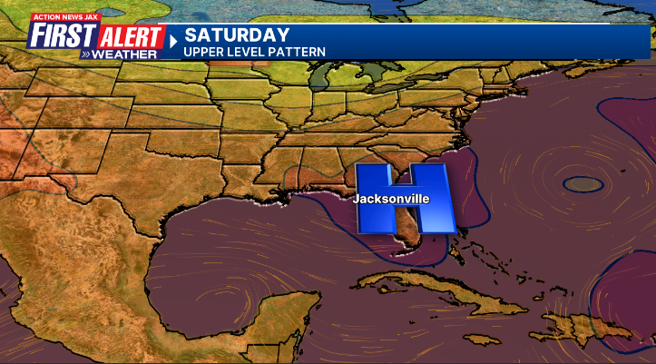
An upper level high remains the main steering current. As this ridge weakens some - or contracts - “Beryl” will gain more latitude which has already been apparent in recent hours. In general, the western edge of the ridge looks to erode enough to allow a more northward move over the weekend. It looks like the upper level high will contract & recenter itself near Jacksonville through the weekend. This carves out a “softness” or alleyway over the Western Gulf also helped out by a trough of low pressure moving across northern latitudes. So the ridge to the east & the trough to the north points to a more northwest or even N/NW movement over the Western Gulf, possibly even more due north late in the “game”. At the very least it looks like heavy rain & flooding for South Texas late in the weekend/early next week as well as the upper Gulf coast of Mexico. Continue to stay up to date on the latest forecasts.


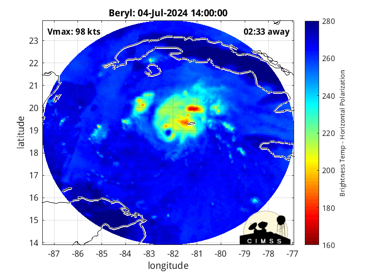
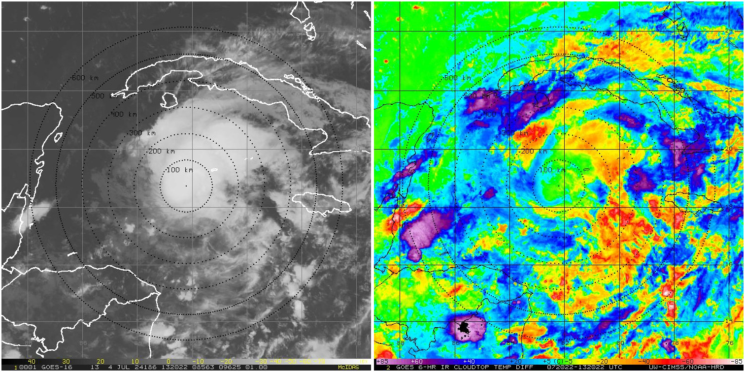
Morphed Integrated Microwave Imagery’s from CIMSS (fascinating!):
From CIRA (CSU):
Mid & upper level wind shear relaxes over the Western Gulf:


More than half a foot of rain for South Texas over the next 5 days:

The European 500mb forecast for Saturday, July 6th. Note the upper high shifting east allowing for an alleyway over the Western Gulf of Mexico:
🌀#HurricaneBeryl
— Damion Mitchell (@DamionMitch) July 3, 2024
📍 Knockpatrick, Manchester #Jamaica
Parts of south Manchester nearest the centre of the storm are now feeling the full impact of the monster. Buildings have lost roof. Powerlines are down and trees have been uprooted. Just listen to the whistle of the wind! pic.twitter.com/TKcqd2IZ4j
An aside: “Beryl” was an early season storm back in 2012 coming ashore in Duval Co. & metro Jacksonville, Florida just below hurricane strength during the weekend of Memorial Day.
:quality(70)/pbs.twimg.com/media/DeFjqSWW4AAIE7m.jpg)
(2) The next tropical wave - ‘96-L’ - come off the coast of Africa over the past weekend but with a decreasing chance for significant development... for now. This wave is following in the footsteps of Beryl but conditions become less favorable the more west this wave gets, & it’s possible this wave will struggle to develop much or at least to be able to maintain much organization. But there will be some gusty squalls moving west across the Caribbean. This wave may still have long term potential once near or over the Western/SW Gulf of Mexico next week.
“Buresh Bottom Line”: * Beryl is crossing the Yucatan Peninsula Friday emerging over the Western Gulf of Mexico Fri. night & over the weekend into early next week before its “final act” (landfall) late in the weekend/early next week.
* The third wave - ‘96-L’ - remains weak. However, some forecast models do indicate the potential for some development once to the Western Gulf next week (sound familiar??).
Stay up to date on the latest forecasts....


REMEMBER WHEN A TROPICAL STORM OR HURRICANE IS APPROACHING: Taping windows is *not* recommended & will not keep glass from breaking. Instead close curtains & blinds.
Realize the forecast cone (”cone of uncertainty”) is the average forecast error over a given time - out to 5 days - & *does not* indicate the width of the storm &/or where damage might occur.


The upper oceanic heat content (UOHC) [tropical cyclone heat potential/TCHP] across the SW Atlantic, Gulf & Caribbean is unseasonably high for this time of year:


Water vapor loop (dark blue/yellow is dry mid & upper level air):


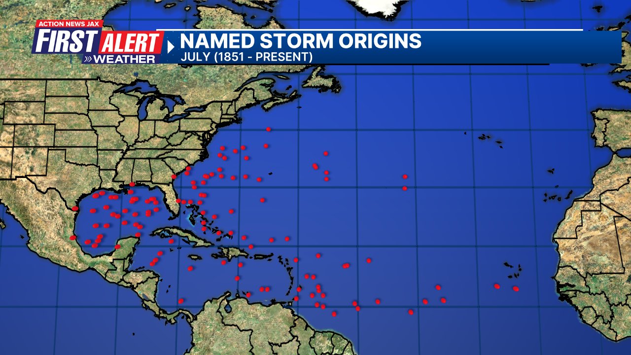
July tropical cyclone origins (early season breeding grounds are the Gulf &/or Western Caribbean:
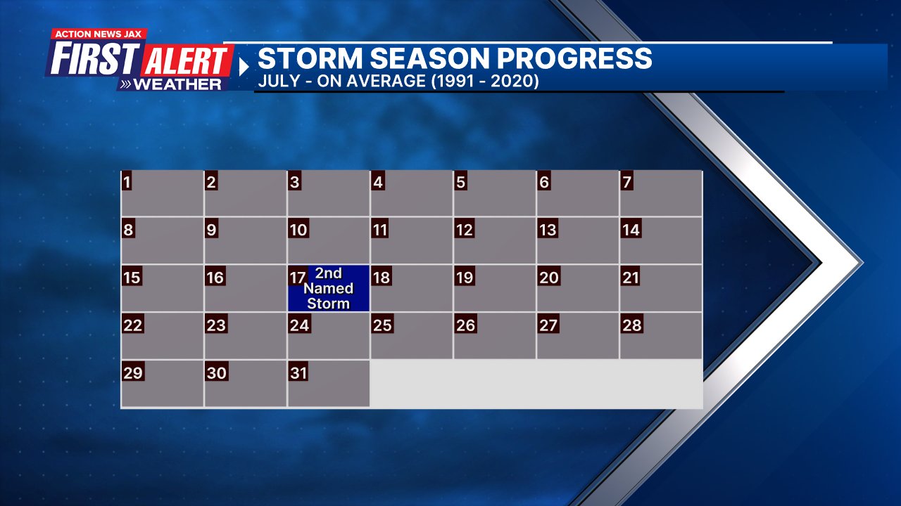
Averages below based on climatology for the Atlantic Basin for July (1 hurricane so far, 3 tropical storms):
Wind shear (red - strong shear; green - low shear):


Saharan dust spreads west each year from Africa driven by the prevailing winds (from east to west over the Atlantic). Dry air = yellow/orange/red/pink. Widespread dust is indicative of dry air that *can* interfere with the development of tropical cyclones. However, sometimes “wanna’ be” waves will just wait until they get to the other side of - or away from - the dust plume then try to develop if other conditions are favorable. In my personal opinion, there is way too much “hoopla” about the presence of Saharan dust & how it relates to tropical cyclones. In any case, the peak of Saharan dust typically is in June & July.

2024 names..... “Debby” is the next name on the Atlantic list (names are picked at random by the World Meteorological Organization... repeat every 6 years). Historic storms are retired [Florence & Michael in ’18 (the last time this year’s list was used)... Dorian in ’19 & Laura, Eta & Iota in ‘20, Ida in ‘21 & Fiona & Ian in ‘22]). In fact, this year’s list of names is rather infamous because of the ‘04 season when Charley, Frances, Jeanne & Ivan - all retired names - hit Florida within a matter of about 6 weeks. The WMO decided - beginning in 2021 - that the Greek alphabet will be no longer used & instead there will be a supplemental list of names if the first list is exhausted (has only happened three times - 2005, 2020 & 2021). The naming of tropical cyclones began on a consistent basis in 1953. More on the history of naming tropical cyclones * here *.


East Atlantic:


Mid & upper level wind shear (enemy of tropical cyclones) analysis (CIMMS). The red lines indicate strong shear:

Water vapor imagery (dark blue indicates dry air):

Deep oceanic heat content over the Gulf, Caribbean & deep tropical Atlantic. The colors will brighten greatly as the water warms to greater depths deeper into the season:

Sea surface temp. anomalies:


SE U.S. surface map:

Surface analysis centered on the tropical Atlantic:

Surface analysis of the Gulf:

Caribbean:

Atlantic Basin wave period forecast for 24, 48, 72 & 96 hours respectively:


East & Central Pacific:
A tropical storm finally developed July 4th - the latest on record (of the satellite era) - over the East Pacific. But Aletta is expected was short-lived & will soon dissipate with no impact on any land areas:


West Pacific:

Global tropical activity:


Cox Media Group
:quality(70)/cloudfront-us-east-1.images.arcpublishing.com/cmg/IOJE2X22SWMV7MILOQWCEAKXGM.jpg)
:quality(70)/cloudfront-us-east-1.images.arcpublishing.com/cmg/HR537GT4PNHNHF7UOCKXVT6QWU.jpg)
:quality(70)/cloudfront-us-east-1.images.arcpublishing.com/cmg/I6ZS6WUC4BBFNHHYM4DKUR5CH4.jpg)
:quality(70)/cloudfront-us-east-1.images.arcpublishing.com/cmg/SOASEBTCCVEZFG2MEOOUWITORM.jpg)
:quality(70)/d1hfln2sfez66z.cloudfront.net/07-08-2024/t_c5fa67fd054f437aa2312a49fd48dbd6_name_file_960x540_1200_v3_1_.jpg)