:quality(70)/cloudfront-us-east-1.images.arcpublishing.com/cmg/WW5AJL3ARQUGDQMAQUNSFX4CLE.jpg)
Jacksonville, Fl. — The “Buresh Bottom Line”: Always be prepared!.....First Alert Hurricane Survival Guide... City of Jacksonville Preparedness Guide... Georgia Hurricane Guide.
STAY INFORMED: Get the * FREE * First Alert Weather app
FREE NEWS UPDATES, ALERTS: Action News Jax app for Apple | For Android
WATCH “Talking & Tracking the Tropics: The Science Behind the Season”
WATCH “Preparing for the Storm”
READ the First Alert Hurricane Center “Survival Guide”
***** ALWAYS CHECK & RE-CHECK THE LATEST FORECAST & UPDATES! *****
-- THERE WILL BE *NO DIRECT* IMPACTS FROM DELTA FOR JACKSONVILLE/NE FL./SE GA.....
If traveling this week/weekend to the Gulf Coast, stay informed on the latest, updated forecast......
*** Hurricane WARNING for Central/SW coastal Louisiana... Tropical Storm WARNING for SE Louisiana including New Orleans... Storm Surge WARNING coastal Louisiana/Mississippi ***
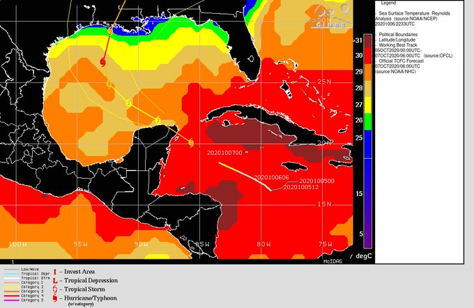
A Caribbean tropical wave was upgraded to tropical depression #26 Sun. night... to tropical storm “Delta” early Monday then to a hurricane Monday evening while moving west/NW across the Caribbean south & southwest of Jamaica. In less than 48 hours, Delta went from a depression to a Cat. 4 hurricane by late Tue. morning. According to Phil Klotzbach, this is the fastest intensification - 70 mph in 24 hours - of an Atlantic tropical cyclone since Wilma in 2005. Like has happened so often this season, this is the fastest ever to the 25th storm beating by more than a month the previous record of Nov. 15th, - take a guess! - 2005. However, hurricane hunter aircraft along with satellite imagery indicate quite a bit of weakening by late Tue. evening. The tiny eye - 5 nautical miles across Tue. - can suddenly contract & allow for strengthening (such as occurred midday Tue.) but such a compact hurricane is also more susceptible to outside interference that can cause fast weakening as we saw Tue. night. At one point, hurricane recon reported the eye had completely collapsed only to see some reorganization with a renewed eye just before landfall. In any case, landfall was about 6:30am EDT Wed. on the far northeast of the Yucatan Peninsula near Cancun (at Puerto Morelos) where sustained winds were near 85 mph & a minimum central pressure of 972 mb was measured.
The Yucatan Peninsula will be little more than speed bump for Delta as the relatively fast-moving tropical cyclone moves over the warm water of the Southern Gulf of Mexico Wed. afternoon & will then reside over warm water through Fri. morning in a relatively low shear zone allowing for strengthening. This is when (Thu./early Fri.) we may see Delta reach its true peak intensity with a more classic appearance on satellite data while the hurricane also expands its wing span (wind field).
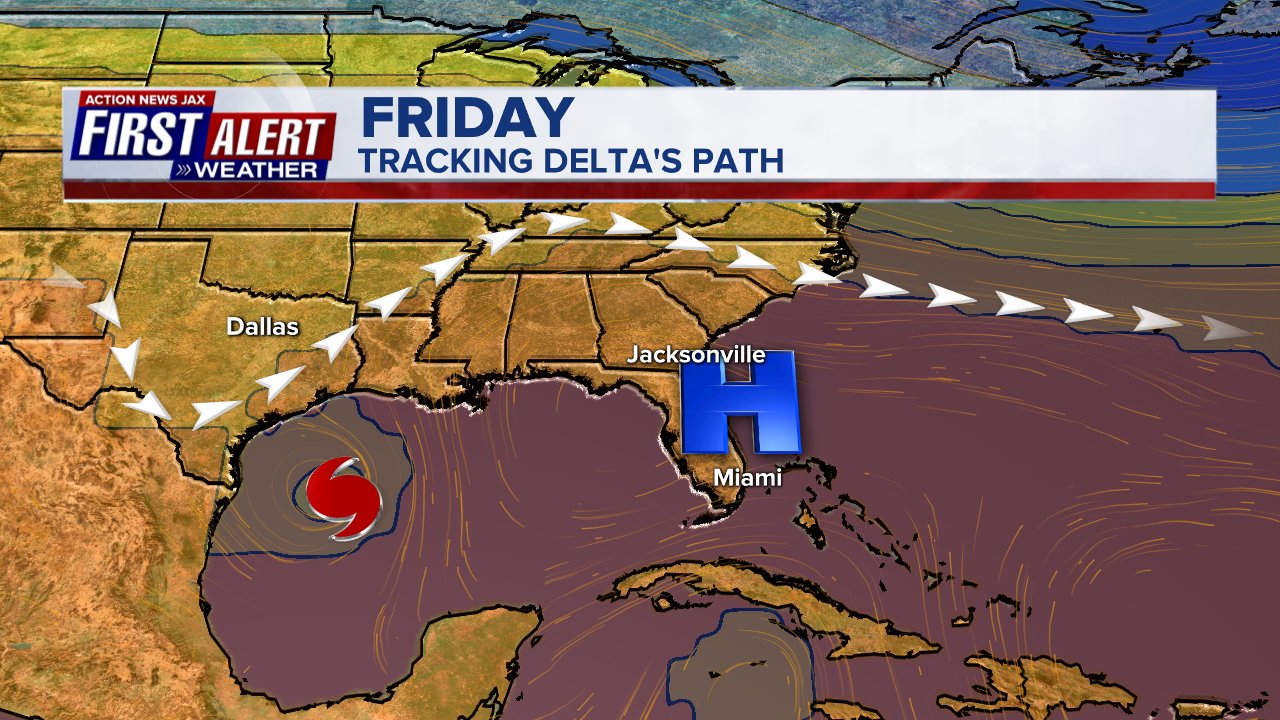
Models had been wildly inconsistent amongst themselves not to mention compared to one another until starting to smooth out later Sunday followed by remarkable agreement the last couple of days. Special balloon launches have been scheduled across much of the South & SE U.S. in hopes of having better/more complete data (input) for the forecast models. The west/northwest movement will become more northwest through Thu. then turning more north, followed by a northeast turn Fri. as a new upper level trough digs into the Lower 48 weakening the upper level ridge across the Northern Gulf. This upper level trough - timing, orientation & strength - will be a major player on where the tropical cyclone goes & to some extent how strong it will be. Given recent trends & typical model biases, it seems a more westward position for a longer period of time has been & will be the way to go which puts Delta over the Western Gulf Thu./Thu. night. Conditions look ripe for at least some re-strengthening once over the Southern Gulf. Models have generally slowed movement over the Gulf later in the week before accelerating late Thu. night/Fri. ahead of the trough bringing Delta ashore Fri. afternoon or early Fri. evening. The GFS is still the faster & more east - late Fri. afternoon east of Cameron & west of New Orleans... the European has speeded up & is over SW Louisiana not far from the Texas/Louisiana border (close to where Laura came ashore in Sept.) by early Fri. evening (the Euro model has had a west bias most of this hurricane season)... & the UKMET is now the fastest - on the Central Louisiana coast by early Fri. afternoon. If the center does come inland just west of New Orleans, there will potentially be a good deal of storm surge pushed into New Orleans. Actual storm surge values will - as always - be difficult to precisely forecast & will be high dependent on the exact location of landfall & the orientation of winds upon approach to the coast.
Currently there’s moderate to strong shear over the Gulf of Mexico on the order of 20+ mph. This shear will lessen some as the upper level high builds to the east (near Fl.) & the upper level trough approaches from the west & northwest. While shear will start to increase by landfall, the vectors will also be in line with the direction from which Delta is moving which may mean a little less impact on the storm. Ocean temps. will not be as warm as the Caribbean/far Southern Gulf & there will also be the typical increased effects of friction upon approach to landfall. There will probably be some dry air pulled into Delta as it’s making landfall. Still.... Delta is likely to be a significant hurricane marching steadily north/northeast on its final journey to the coast. While Delta may be off its peak when it hits Louisiana & nearby areas, the hurricane is likely to still be at least a Cat. 2 if not 3 with a very dangerous storm surge near & to the east of the eye.
Sea surface temps. over the Gulf of Mexico & along the forecast path of Delta are generally 82-85 degrees F - plenty warm though admittedly not the bath water Delta developed over in the Caribbean. The cooler shelf water is very evident over the far Northern Gulf.


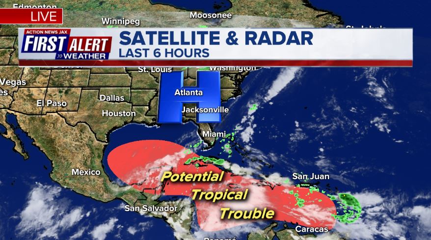
Water vapor imagery shows a moistening atmosphere across the Gulf & in the vicinity of Delta....


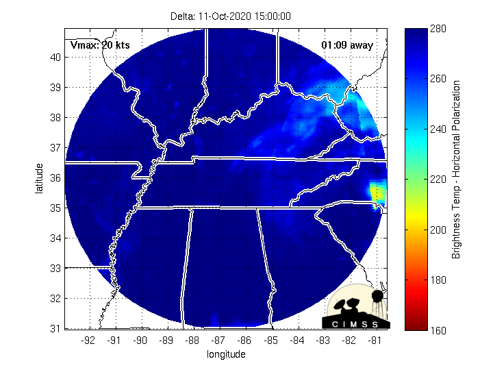
Microwave imagery courtesy CIMSS: (interesting in that it nicely shows the brief but intense burst in strengthening Tue. followed by the near collapse Tue. night only to try to re-strengthen near landfall):
The upper level (500 mb) forecast for Friday shows the approaching trough that will help steer & accelerate Delta north then northeast around the western edge of the upper level high over & near Fl. (our “protector”):
Persistent, broad & strong high pressure at northern latitudes helping to induce low pressure at lower latitudes:
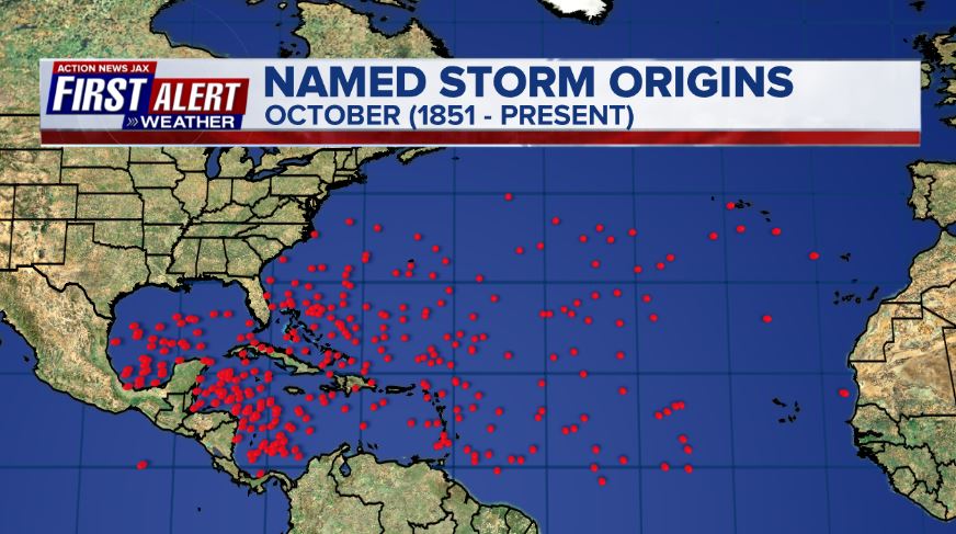
October tropical cyclone origin points are clustered over the Caribbean, Gulf of Mexico & SW Atlantic:
Atlantic Basin wave forecast for 24, 48 & 72 hours respectively (major wave action at Fl./Ga. beaches through early next week due to persistent brisk onshore flow (high pressure to the north) combined with easterly swells from distant Teddy:


:quality(70)/cloudfront-us-east-1.images.arcpublishing.com/cmg/VGODFKYHBVHJTB5KX6OTZSYLLA.jpg)
:quality(70)/cloudfront-us-east-1.images.arcpublishing.com/cmg/HA4HZHOLBOFGR6SRP4W4POQITA.jpg)
:quality(70)/d1hfln2sfez66z.cloudfront.net/09-07-2024/t_12333aba12c2411cae7a90774a814fc6_name_file_960x540_1200_v3_1_.jpg)
:quality(70)/cloudfront-us-east-1.images.arcpublishing.com/cmg/T7KAHKUVBOP54VPA2N6QQFREP4.jpg)
:quality(70)/cloudfront-us-east-1.images.arcpublishing.com/cmg/4IZJQXHZUFBZ7GXNJ5ZSLLYW7A.jpg)