:quality(70)/cloudfront-us-east-1.images.arcpublishing.com/cmg/JIFG55NSN5HKZK6LKEZ4C7UU5I.jpg)
Jacksonville, Fl. — The “Buresh Bottom Line”: Always be prepared!.....First Alert Hurricane Preparation Guide... City of Jacksonville Preparedness Guide... Georgia Hurricane Guide.
STAY INFORMED: Get the * FREE * First Alert Weather app
FREE NEWS UPDATES, ALERTS: Action News Jax app for Apple | For Android
WATCH “Preparing for the Storm”
WATCH “The Ins & Outs of Hurricane Season”
READ the First Alert Hurricane Center “Survival Guide”
LISTEN & WATCH “Surviving the Storm” - WOKV Radio & Action News Jax
***** ALWAYS CHECK & RE-CHECK THE LATEST FORECAST & UPDATES! *****
REMEMBER WHEN A TROPICAL STORM OR HURRICANE IS APPROACHING: Taping windows is *not* recommended & will not keep glass from breaking. Instead close curtains & blinds.
Realize the forecast cone (”cone of uncertainty”) is the average forecast error over a given time - out to 5 days - & *does not* indicate the width of the storm &/or where damage that might occur.

*** LOCAL (Jacksonville/NE Fl./SE Ga.) IMPACTS FROM THE TROPICS:
* “Idalia”: Impacts centered on Wednesday...
* Hurricane Franklin: Rip currents & an easterly swell (waves) at the beaches through Tue. while 1,000+ miles to the east of Jacksonville
The Atlantic Basin Overview:
“Idalia” has turned north and will pass through the Yucatan Channel into the Gulf of Mexico Monday then accelerate north/northeast across the Eastern Gulf of Mexico. The tropical cyclone will be headed for NW Florida &/or the Eastern Panhandle by Tue. night/Wednesday as a hurricane.
A Storm Surge WARNING: Englewood northward to Indian Pass, including Tampa Bay.... A Hurricane WARNING: Cuban province of Pinar del Rio ... Middle of Longboat Key northward to Indian Pass, including Tampa Bay. A Tropical Storm WARNING: Yucatan Peninsula from Tulum to Rio Lagartos, including Cozumel ... Isle of Youth Cuba ... Dry Tortugas Florida ... Chokoloskee northward to the Middle of Longboat Key ... West of Indian Pass to Mexico Beach ... Sebastian Inlet, Florida to Altamaha Sound, Georgia... A Storm Surge WATCH: Chokoloskee northward to Englewood, including Charlotte Harbour ... Mouth of the St. Mary’s River to South Santee River South Carolina... A Hurricane WATCH: Englewood to the Middle of Longboat Key... A Tropical Storm WATCH: Lower Florida Keys west of the west end of the Seven Mile Bridge ... Altamaha Sound northward to South Santee River South Carolina.
Meanwhile...“Franklin” hit Haiti & especially the Dominican Republic with very heavy rain last Wed. The hurricane rapidly intensified to a high end Cat. 4 Monday when the storm finally found the “sweet spot” of the SW Atlantic but at least is not a threat to land. There will be some distant impacts (waves & rip currents) on the U.S. east coast through midweek. Franklin will accelerate to the north/northeast, & there will be some impacts for Bermuda by Tuesday but *not* a direct hit on the island. It now looks like the turn northeast over the NW Atlantic will be sharp enough to keep most impacts east of Canada.

(1) The area of disturbed weather near the Yucatan - Tropical depression #10 - strengthened into tropical storm “Idalia” late Sunday morning.
Local (Jacksonville/NE Fl./SE Ga.) Impacts (BASED ON CURRENT FORECAST & SUBJECT TO CHANGE) centered on Wednesday with rapid improvement Wed. night/Thu.:
Rain - An average of 2-4″, locally more west of Highway 301.... 1-3″(+) from Highway 301 to I-95... 1-2″(+) east of I-95 to the beaches. The fast movement of Idalia will keep amounts lower than what’s experienced with slower moving tropical systems. The area has also been unseasonably dry the last few weeks so there is not an overly large amount of water “in the system” which will help some when it comes to fresh water flooding.
Winds - averaging 40-60+ mph west of Highway 301 with gusts 70+ mph. Closer to I-75 - from Lake City to south of Waycross - sustained hurricane force winds of 74+ mph will be possible. From Highway 301 to the beaches, sustained winds Wed. averaging 30-50 mph with gusts 60+ mph. If Idalia turns east sooner (faster) or comes ashore more to the south along the west coast than forecast, it’s possible sustained winds could be stronger - near hurricane strength - for a larger part of NE Fl. & SE Ga.
Direction: winds will be out of the S/SE Tue. night then out of the south by early Wed. veering to out of the SW by midday then out of the west & eventually NW (offshore) by late afternoon into the evening.
Coast/beaches: windy with winds of 30-50 mph & gusts 50-60+ mph. There will be a high rip current risk enhanced by distant hurricane Franklin & an easterly swell. A full moon Wed. evening will also give an astronomical boost to surf. Based on the current forecast, this should not be particularly severe for our beaches from an erosion standpoint (compared to Nicole & Ian from last year, for example). Seas will peak at an average 5-10 feet Wed. with surf averaging 4-8 feet, locally higher. The best advice is to stay out of the ocean through midweek but if you do insist on going in the water, always swim & surf with a buddy & as close to a lifeguard as possible. Winds will become offshore & “clean up” the surf by late Wed./Wed. night but with a continued high & dangerous risk of rip currents.
Storm surge is forecast to average 1-3 feet along the NE Fl. coast & St. Johns River... & 2-4 feet for the coast of Southeast Georgia.
St. Johns River: Based on the latest forecast... strong winds from the south will push water northward to downtown causing potential flooding, the extent of which will depend on how close & how strong the center is to Jacksonville. Once the center of Idalia moves by & away, strong winds on the backside out of the west & northwest will help to “empty” some of the water to the east. All areas along the river & its tributaries - from Putnam Co. through Clay/St. Johns & Duval Co. will be subject to flooding & backwash. Unique & varied topography along the river, intracoastal & coast can & will lead to localized higher surge & flooding. As a whole, storm surge is forecast to average 1-3 feet.
Tornadoes: At least a few tornadoes are expected late Tue. through late Wed. centered on about sunrise Wed. through early afternoon Wed.
Damage: Idalia’s winds will be the biggest threat along with a few tornadoes. The most widespread & significant wind damage looks to be west of I-95 so largely an inland storm. There will be some storm surge along the coast, St. Johns River & its tributaries. Power outages can be expected & may become widespread & long lasting if Idalia remains relatively powerful well inland - possibly to or near Jacksonville due to its relatively fast movement.
REALIZE ALL THESE IMPACTS ARE BASED ON CURRENT FORECASTS THAT WILL CHANGE TO AT LEAST SOME DEGREE... & UNDERSTAND IMPACTS WILL BE MUCH GREATER CLOSER TO LANDFALL (PANHANDLE & UPPER FL. WEST COAST).
REMEMBER THAT THE FORECAST CONE ONLY INVOLVES THE EXPECTED PATH OF THE STORM. DON’T GET FIXATED ON THE CENTER & REALIZE IMPACTS FROM THE STORM WILL EXTEND FAR AWAY FROM THE CENTER.
Forecast Discussion: After meandering most of Sunday, Idalia turned northward overnight as expected but has been moving only slowly northward with the center having a tendency to jump around a bit due to bursts of strong convection. The center will become more organized &, in fact, radar imagery & recon data show hints of an eye Mon. night. As Idalia enters the Southern Gulf followed by a turn more northeast - while accelerating - toward Florida with the Panhandle & upper west coast susceptible to a landfall as a Category 3 (winds greater than 110 mph near the eye). *At this point*... a landfall on the far Eastern Panhandle or approximately Big Bend seems to be the area to focus on.
The European model continues taking the storm to a landfall north of Tampa - pretty close to Cedar Key - Wed. morning - a little faster & stronger than in some previous model output as well as a little more north or up the Fl. coast but still east of the GFS model.
The American GFS model - which was late to the “party” - takes a strong hurricane more north with a landfall on the Eastern Panhandle of Florida early Wed. & has been slowly trending eastward though recently has stabilized. For the most part, both operational models have recently stayed quite consistent within their own ranks - the European model more south/southeast while the GFS is more to the west.
It’s possible the interaction with land could cause at least a wobble to the east Wed. morning.
Idalia is forecast to turn rather sharply eastward by Wed. night/Thu. moving off the coast of the Carolina’s over the Western Atlantic.
Based on the latest forecast with at least some changes still likely:
Track: northward into the Southern Gulf with a turn more northeast toward Florida with the Eastern Panhandle & much of the upper west coast susceptible to a landfall. *At this point*... a landfall on the far Eastern Panhandle or Big Bend seems to be the area to focus on to as far south as just north of Tampa. Weakening will then commence but will be slowed because of otherwise favorable meteorological conditions. The fast movement means Idalia could still be a hurricane well inland while moving across I-10 before becoming a tropical storm somewhere near the Fl./Ga. border while moving north & northwest of Jacksonville.
Timing: Into the far Southern Gulf Tuesday... starting to accelerate to the northeast or N/NE over the Eastern Gulf into Wed. Highest potential impacts on Florida from late Tue. through Wed. evening depending, of course, on the exact track & intensity.
Strength: while sea surface temps. & oceanic heat content are very warm (usually are this time of year but even warmer than avg.), that alone will not necessarily result in a significant storm. Other factors have to be considered, especially wind shear & mid & upper level moisture. So...
(1) moisture - plenty. There’s lots of moisture present. Upon approach to land followed by the landfall, dry continental air will have a tendency to wrap around the underside (south) leaving a tropical cyclone heavily weighted on its north & northeast side at midweek following landfall.
(2) Moderate to strong shear (30+ mph) out of the west has been persisting. It looks like there will be some decrease in shear the next few days as the system approaches land & there will be some upper level ventilation thanks to a nearby trough of low pressure. In addition... Idalia will be moving in line with the mid/upper level wind (shear) vector so the effects of the shear should be lessened. With moisture (humidity) remaining favorable, a hurricane is forecast at landfall - as strong as a Cat. 3 while strengthening all the way up to landfall.
Summary: The forecast is for Idalia to be a hurricane before & at landfall. A midweek strike is forecast from the Eastern Fl. Panhandle to the upper west coast of Fl. So biggest impacts appear to be from approximately the Eastern Panhandle to the Big Bend to north of Tampa. There will be lots of folks traveling late next week with Labor Day weekend just around the corner so stay up to date on the latest forecasts, but it does appear that Idalia will have cleared the U.S. by at least Fri. though may linger east of the Carolina’s & Chesapeake Bay but offshore into the weekend. Don’t focus too much on the center of the storm as impacts will be far away from the center point of Idalia including a storm surge possibly near half a foot for Tampa Bay.


Spaghetti plots including ensemble (instead of running just a single forecast, the computer model is run a number of times from slightly different starting conditions. The complete set of forecasts is referred to as the ensemble, and individual forecasts within it as ensemble members.) “Idalia”:

Peak storm surge forecast in feet above ground level:

The times below correlate with “most likely” arrival time of winds equal to or greater than 39 mph:

Brighter colors indicate higher probabilities of winds greater than or equal to 39 mph. Realize any probability above zero is significant considering most days the probability is zero.

Forecast rainfall in inches:


From S. Fl. Water Management District:

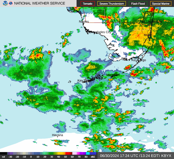
Key West radar:
Water vapor loop. Blue color indicates dry mid & upper level air, white & green indicates high moisture levels:

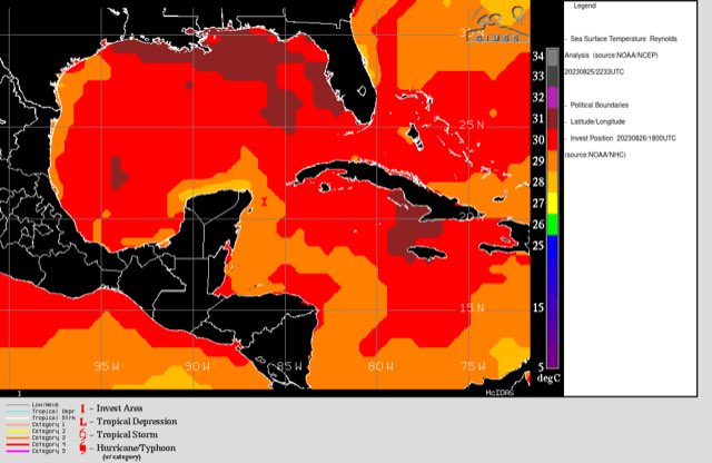
Sea surface temps. are plenty warm:
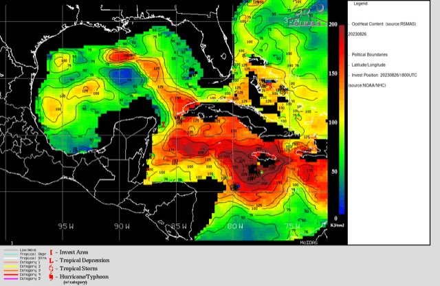
Oceanic heat content is pretty impressive, especially within a narrow ribbon from Cuba through Central to the Northern Gulf:

Forecast rainfall, European model:

Forecast rainfall, GFS model (is forecasting landfall farther to the west):

(2) “Franklin” (upgraded late last Sunday) over the Northern Caribbean becoming a powerful hurricane east of the Bahamas over the SW Atlantic making the sharp turn to the north. The combination of lessening shear plus strong upper level diffluence thanks to a trough of low pressure to the north with very warm water below helped intensify Franklin to a Cat. 4 Monday/ There will be some impacts for Bermuda Tue. into Wed. as the eye moves by to the west & north but not a direct hit on the island. Franklin should take a sharp enough turn to the east to *not* have significant direct impacts on Canada with the possible exception of some wind + rough seas & surf for far Eastern Newfoundland & Labrador.
Franklin will also be strong enough - while still well to the east of Florida - to produce an easterly swell at area beaches resulting in a heightened rip current risk all up & down the U.S. eastern seaboard through midweek. A full moon will also add an astronomical boost to seas & surf.
The forecast track is pretty straight forward with a well established alleyway across the Western Atlantic with Franklin accelerating over the next several days while maturing then bending rather sharply to the northeast once at about Jacksonville’s latitude. Franklin should be at about Jacksonville’s latitude but 1,000+ miles to the east early Tue.
A Tropical Storm WATCH for Bermuda

#firstalertwx whoa! @ActionNewsJax @WOKVNews https://t.co/907MkzK3zy
— Mike Buresh (@MikeFirstAlert) August 25, 2023


(3) And yet another tropical wave is moving west off the coast of Africa. Some gradual development will be possible over the open E. Atlantic.
Check out the upper oceanic heat content (UOHC) [tropical cyclone heat potential/TCHP] across the SW Atlantic, Gulf & Caribbean. The warmth is very deep. But keep in mind warm ocean temps. alone doesn’t necessarily equate to a “big” hurricane season (need other ingredients & factors to be favorable too) but it’s obvious there is a lot of very warm water at great depths over the Caribbean & Gulf of Mexico:


Water vapor loop (dark blue/yellow is dry mid & upper level air):


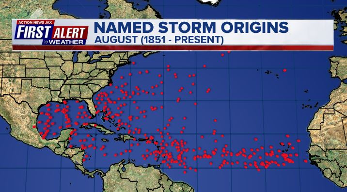
July tropical cyclone origins:
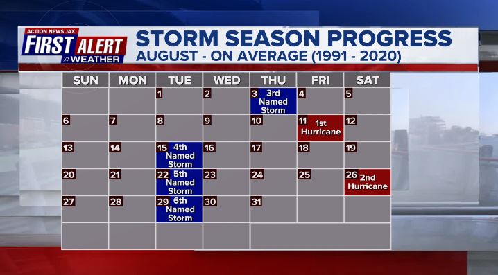
Averages below based on climatology for the Atlantic Basin for August:
Wind shear:


Saharan dust spreads west each year from Africa by the prevailing winds (from east to west over the Atlantic). Dry air - yellow/orange/red/pink. Widespread dust is indicative of dry air that can impede the development of tropical cyclones. However, sometimes “wanna’ be” waves will just wait until they get to the other side of - or away from - the plume then try to develop if other conditions are favorable. In my personal opinion, way too much is made about the presence of Saharan dust & how it relates to tropical cyclones. In any case, the peak of Saharan dust typically is in June & July.

2023 names..... “Jose” is the next name on the Atlantic list (names are picked at random by the World Meteorological Organization... repeat every 6 years). Historic storms are retired [Florence & Michael in ’18... Dorian in ’19 & Laura, Eta & Iota in ‘20, Ida in ‘21 & Fiona & Ian in ‘22]). In fact, this year’s list of names is rather infamous with “Katrina”, “Rita” & “Wilma” retired from the ‘05 list & “Harvey”, “Irma”,“Maria” & “Nate” from the ‘17 list. The WMO decided - beginning in 2021 - that the Greek alphabet will be no longer used & instead there will be a supplemental list of names if the first list is exhausted (has only happened three times - 2005, 2020 & 2021). The naming of tropical cyclones began on a consistent basis in 1953. More on the history of naming tropical cyclones * here *.

East Atlantic:


Mid & upper level wind shear (enemy of tropical cyclones) analysis (CIMMS). The red lines indicate strong shear:

Water vapor imagery (dark blue indicates dry air):

Deep oceanic heat content over the Gulf, Caribbean & deep tropical Atlantic. The brighter colors are expanding dramatically as we near the peak of the hurricane season.:

Sea surface temp. anomalies:


SE U.S. surface map:

Surface analysis centered on the tropical Atlantic:

Surface analysis of the Gulf:

Caribbean:

GFS wave forecast at 48 & 72 hours (2 & 3 days):


Atlantic Basin wave period forecast for 24, 48 & 72 hours respectively:


East/Central Pacific:
I wrote about “Hilary” near the top after the Atlantic waves. Elsewhere.....


“Irwin” to stay over the open E. Pacific:

West Pacific:

Global tropical activity:


“Damrey” forecast to stay east of Japan while weakening:

“Saola” is a formidable typhoon not far from the Philippines while making a loop & moving very slowly & may eventually - by Wed. into Thu. - move just south of Taiwan.

“Haikui”:


Cox Media Group
:quality(70)/d1hfln2sfez66z.cloudfront.net/09-08-2024/t_83f3de6c70ef4676a4451de0f4e4b789_name_file_960x540_1200_v3_1_.jpg)
:quality(70)/cloudfront-us-east-1.images.arcpublishing.com/cmg/HA4HZHOLBOFGR6SRP4W4POQITA.jpg)
:quality(70)/cloudfront-us-east-1.images.arcpublishing.com/cmg/U3HNYAT5BZE27K74K4PORV53WE.jpeg)
:quality(70)/cloudfront-us-east-1.images.arcpublishing.com/cmg/3LI6RTTSSDLCYFDWXOQG4MNGVI.jpg)
:quality(70)/d1hfln2sfez66z.cloudfront.net/09-06-2024/t_85ae07bed05e4d9e9458631dc6f35024_name_file_960x540_1200_v3_1_.jpg)