
Jacksonville, Fl. — The “Buresh Bottom Line”: Always be prepared!.....First Alert Hurricane Preparation Guide... City of Jacksonville Preparedness Guide... Georgia Hurricane Guide.
STAY INFORMED: Get the * FREE * First Alert Weather app
FREE NEWS UPDATES, ALERTS: Action News Jax app for Apple | For Android
WATCH “Preparing for the Storm”
WATCH “The Ins & Outs of Hurricane Season”
READ the First Alert Hurricane Center “Preparation Guide”
***** ALWAYS CHECK & RE-CHECK THE LATEST FORECAST & UPDATES! ****
Tropics threats for Jacksonville/NE Florida/SE Georgia: No direct impacts from tropical systems with ‘potential tropical cyclone 8′ far enough north so as to not have any significant direct impacts. In fact, some dry air should wrap around the disturbance across NE Fl. & SE Ga. helping to cut off the many days of heavy rainfall.
“Buresh Bottom Line”:
* “Gordon” is over the Eastern Atlantic & will stay far to the east over the open Atlantic & will struggle against shear & dry air the next few days. The avg. date for the 7th named storm of the Atlantic season is Sept. 3rd so a bit behind this year.
* A couple of tropical waves between the Caribbean & Africa will remain weak... for now.
* Low pressure has formed east/northeast of Florida & near north of the Bahamas & will move north/NW possibly acquiring tropical or subtropical characteristics. Heads up from the Carolina’s to Chesapeake Bay & nearby areas the next few days.
The Atlantic Basin Overview:
(1) A Tropical Storm WARNING: Edisto Beach, South Carolina northward to Ocracoke Inlet, North Carolina.
Low pressure - ‘95-L’ / ‘Potential Tropical Cyclone 8′ - has developed east of Florida/Ga. & will bend back to the northwest crossing the very warm Gulf Stream in the process. Such a track puts the Carolina’s on alert for a possible tropical system by Mon. into Tue. The Climavision ‘Horizon’ model (see map further down) has indicated this potential for several days but is quite weak & trending south with a weak low into S. Carolina early Monday. This scenario is similar to the GFS model while the European model is slower & eventually more north with a low moving into N. Carolina Tue.-Wed. In any case... at least several days of heavy rain can be expected from S. Carolina north to the Mid-Atlantic.
(2) Multiple tropical waves are moving west & northwest between the Caribbean & Africa - something one would expect this time of year. At least one - ‘92-L’ appears to be losing its development potential while a stronger tropical wave - ‘93-L’ to its east was upgraded Wed. morning to tropical depression seven & Fri. morning to tropical storm Gordon then back down to a depression late Sunday. “Gordy” is likely to stay far to the east over the Atlantic as the Bermuda high remains displaced to the east & northeast over the Atlantic. Such a position favors an alleyway for systems to turn north over the Central Atlantic... at least over the next 10-12 days or so. The tropical cyclone has been struggling against mid & upper level wind shear & dry air. The environment will not change much through midweek, so Gordon could weaken to a trough of low pressure/open wave again. Many models show eventual re-generation in the longer range but - again - staying far out to sea.
Fitting the pattern for the increased tropical activity overall - as well as the recent wet/cloudy spell for Florida - is persistent & seasonally strong surface high pressure at northern latitudes from the Central U.S. to the Northwest Atlantic. This high pressure will bring has brought an early taste of fall across the Northern U.S. & generally encourages low pressure to the south - a pattern that often favors tropical development at southern latitudes. It’s Mother Nature’s constant balancing/compensating act. And it’s likely why we’ve seen forecast models struggle with the overall pattern developing sometimes spurious & frequent low pressure areas near & south of about 35 degrees N.


Francine’s heavy rain & flooding threat north all the way to Memphis & Paducah. Very heavy rain for much of the Southeast yet again for the next few days with or without direct influence from the tropics:


Climavision ‘Horizon’ model for early Monday, 09/16 showing weak low pressure moving into Central S. Carolina - more south & faster than previously:


‘Velocity potential anomalies’ below still shows “sinking” air (brown lines) across the Atlantic Basin gradually breaking down. In such a state, tropical development can occur but overall conditions are not as conducive as when there is overall rising (green lines) air such as much of the Pacific Basin where convection is active. This “pulse” of upward motion is moving eastward toward the Atlantic Basin & may help to be a cause for an uptick in Atlantic activity late this month into October.

REMEMBER WHEN A TROPICAL STORM OR HURRICANE IS APPROACHING: Taping windows is *not* recommended & will not keep glass from breaking. Instead close curtains & blinds.
Realize the forecast cone (”cone of uncertainty”) is the average forecast error over a given time - out to 5 days - & *does not* indicate the width of the storm &/or where damage might occur.

The upper oceanic heat content (UOHC) [tropical cyclone heat potential/TCHP] across the SW Atlantic, Gulf & Caribbean is very high:


Water vapor loop (dark blue/yellow is dry mid & upper level air):


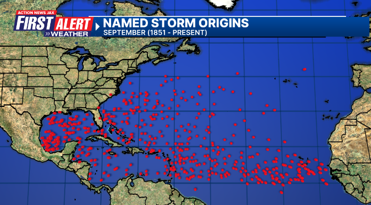
September tropical cyclone origins (early season breeding grounds are the Gulf &/or Western Caribbean:
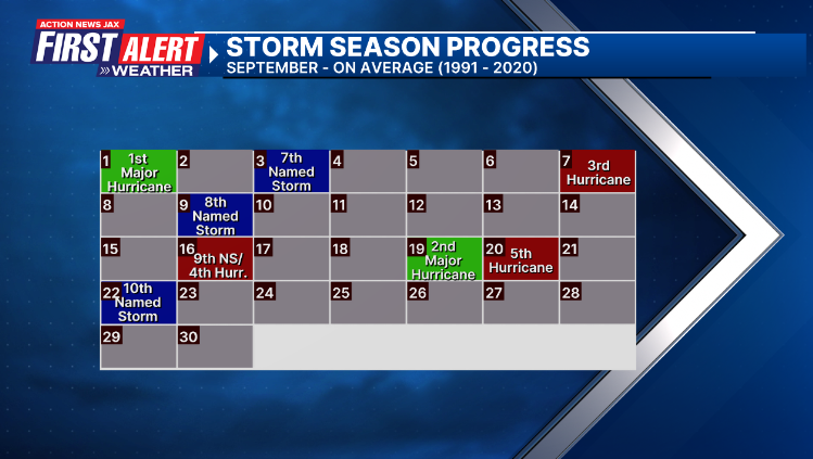
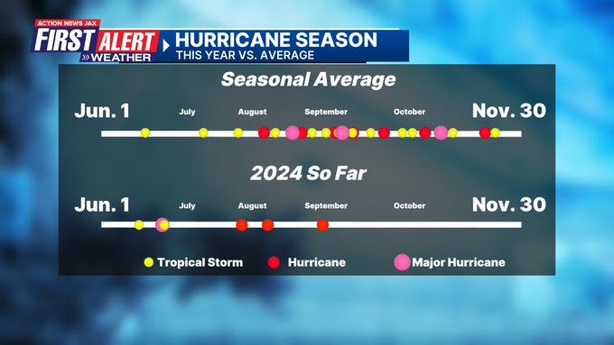
Averages below based on climatology for the Atlantic Basin for September (2 hurricane so far, 3 tropical storms):
Wind shear (red - strong shear; green - low shear):


Saharan dust spreads west each year from Africa driven by the prevailing winds (from east to west over the Atlantic). Dry air = yellow/orange/red/pink. Widespread dust is indicative of dry air that *can* interfere with the development of tropical cyclones. However, sometimes “wanna’ be” waves will just wait until they get to the other side of - or away from - the dust plume then try to develop if other conditions are favorable (we’ve already seen this with Beryl & Debby this year). In my personal opinion, there is way too much “hoopla” about the presence of Saharan dust & how it relates to tropical cyclones. In any case, the peak of Saharan dust typically is in June & July.

2024 names..... “Helene” is the next name on the Atlantic list (names are picked at random by the World Meteorological Organization... repeat every 6 years). Historic storms are retired [Florence & Michael in ’18 (the last time this year’s list was used)... Dorian in ’19 & Laura, Eta & Iota in ‘20, Ida in ‘21 & Fiona & Ian in ‘22]). In fact, this year’s list of names is rather infamous because of the ‘04 season when Charley, Frances, Jeanne & Ivan - all retired names - hit Florida within a matter of about 6 weeks. The WMO decided - beginning in 2021 - that the Greek alphabet will be no longer used & instead there will be a supplemental list of names if the first list is exhausted (has only happened three times - 2005, 2020 & 2021). The naming of tropical cyclones began on a consistent basis in 1953. More on the history of naming tropical cyclones * here *.

Peak of the hurricane season Sept. 10th:


East Atlantic:


Mid & upper level wind shear (enemy of tropical cyclones) analysis (CIMMS). The red lines indicate strong shear:

Water vapor imagery (dark blue indicates dry air):

Deep oceanic heat content over the Gulf, Caribbean & deep tropical Atlantic. The colors will brighten greatly as the water warms to greater depths deeper into the season:

Sea surface temp. anomalies:


SE U.S. surface map:

Surface analysis centered on the tropical Atlantic:

Surface analysis of the Gulf:

Caribbean:

Atlantic Basin wave period forecast for 24, 48, 72 & 96 hours respectively:


East & Central Pacific:


Hawaii satellite imagery:


West Pacific:

Global tropical activity:


“Bebinca” is headed into China:


Cox Media Group


