Jacksonville, Fl. — The “Buresh Bottom Line”: Always be prepared!.....First Alert Hurricane Preparation Guide... City of Jacksonville Preparedness Guide... Georgia Hurricane Guide.
STAY INFORMED: Get the * FREE * First Alert Weather app
FREE NEWS UPDATES, ALERTS: Action News Jax app for Apple | For Android
WATCH “Preparing for the Storm”
WATCH “The Ins & Outs of Hurricane Season”
READ the First Alert Hurricane Center “Preparation Guide”
***** ALWAYS CHECK & RE-CHECK THE LATEST FORECAST & UPDATES! ****
Tropics threats for Jacksonville/NE Florida/SE Georgia: None.
The Atlantic Basin Overview:
Multiple tropical waves extend from the Caribbean to the coast of Africa & may have some long term potential to slowly develop while moving westward across the Atlantic Basin. Right now most forecast models are honing in on a wave moving into or near the Caribbean by about the middle of next week. As one would expect with a long range forecast, model consistency is poor, but this will be a feature to track & watch.
We’re also seeing mixed signals regarding a nearly stationary from the Gulf to the Western Atlantic that gets reinforced by a series of upper level troughs & possible low pressure developing at the surface along the front. This could be some “in-close” development next week or beyond anywhere from the Gulf to the far Western Atlantic. Not much to truly latch onto yet but an area to watch.


REMEMBER WHEN A TROPICAL STORM OR HURRICANE IS APPROACHING: Taping windows is *not* recommended & will not keep glass from breaking. Instead close curtains & blinds.
Realize the forecast cone (”cone of uncertainty”) is the average forecast error over a given time - out to 5 days - & *does not* indicate the width of the storm &/or where damage might occur.

The upper oceanic heat content (UOHC) [tropical cyclone heat potential/TCHP] across the SW Atlantic, Gulf & Caribbean is unseasonably high for this time of year:


Water vapor loop (dark blue/yellow is dry mid & upper level air):


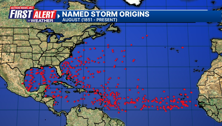
August tropical cyclone origins (early season breeding grounds are the Gulf &/or Western Caribbean:
Averages below based on climatology for the Atlantic Basin for August (1 hurricane so far, 3 tropical storms):

Wind shear (red - strong shear; green - low shear):


Saharan dust spreads west each year from Africa driven by the prevailing winds (from east to west over the Atlantic). Dry air = yellow/orange/red/pink. Widespread dust is indicative of dry air that *can* interfere with the development of tropical cyclones. However, sometimes “wanna’ be” waves will just wait until they get to the other side of - or away from - the dust plume then try to develop if other conditions are favorable (we’ve already seen this with Beryl & Debby this year). In my personal opinion, there is way too much “hoopla” about the presence of Saharan dust & how it relates to tropical cyclones. In any case, the peak of Saharan dust typically is in June & July.

2024 names..... “Francine” is the next name on the Atlantic list (names are picked at random by the World Meteorological Organization... repeat every 6 years). Historic storms are retired [Florence & Michael in ’18 (the last time this year’s list was used)... Dorian in ’19 & Laura, Eta & Iota in ‘20, Ida in ‘21 & Fiona & Ian in ‘22]). In fact, this year’s list of names is rather infamous because of the ‘04 season when Charley, Frances, Jeanne & Ivan - all retired names - hit Florida within a matter of about 6 weeks. The WMO decided - beginning in 2021 - that the Greek alphabet will be no longer used & instead there will be a supplemental list of names if the first list is exhausted (has only happened three times - 2005, 2020 & 2021). The naming of tropical cyclones began on a consistent basis in 1953. More on the history of naming tropical cyclones * here *.


East Atlantic:


Mid & upper level wind shear (enemy of tropical cyclones) analysis (CIMMS). The red lines indicate strong shear:

Water vapor imagery (dark blue indicates dry air):

Deep oceanic heat content over the Gulf, Caribbean & deep tropical Atlantic. The colors will brighten greatly as the water warms to greater depths deeper into the season:

Sea surface temp. anomalies:


SE U.S. surface map:

Surface analysis centered on the tropical Atlantic:

Surface analysis of the Gulf:

Caribbean:

Atlantic Basin wave period forecast for 24, 48, 72 & 96 hours respectively:


East & Central Pacific:
“Hone” became a hurricane Sat. night with its closest approach to the Big Island of Hawaii through the day Sunday producing some squalls & localized flooding but - in the end - not a major hit on the islands. Hone is back down to a tropical storm & will move steadily west/northwest away from the islands while gradually weakening:

“Gilma” will gradually weaken while slowly gaining latitude as the tropical cyclone moves into the Central Pacific basin. What’s left of the system will be a little north of Hawaii late this week while becoming post-tropical. Only minor impacts in the form of gusty winds & rough seas/surf for Hawaii:

“Hector”:


Hawaii satellite imagery:


West Pacific:

Global tropical activity:


Typhoon “Shanshan” is forecast to move into Western Japan by Thu.:


Cox Media Group