:quality(70)/cloudfront-us-east-1.images.arcpublishing.com/cmg/JIFG55NSN5HKZK6LKEZ4C7UU5I.jpg)
Jacksonville, Fl. — The “Buresh Bottom Line”: Always be prepared!.....First Alert Hurricane Preparation Guide... City of Jacksonville Preparedness Guide... Georgia Hurricane Guide.
STAY INFORMED: Get the * FREE * First Alert Weather app
FREE NEWS UPDATES, ALERTS: Action News Jax app for Apple | For Android
WATCH “Preparing for the Storm”
WATCH “The Ins & Outs of Hurricane Season”
READ the First Alert Hurricane Center “Preparation Guide”
***** ALWAYS CHECK & RE-CHECK THE LATEST FORECAST & UPDATES! *****
*** LOCAL (Jacksonville/NE Fl./SE Ga.) IMPACTS FROM THE TROPICS: None through at least the 4th of July
The Atlantic Basin Overview:
(1) A Hurricane WARNING: Barbados ... St. Lucia ... St. Vincent and the Grenadine Islands ... Grenada ... Tobago. A Tropical Storm WARNING : Martinique... A Tropical Storm WATCH: Dominica.
The strong tropical wave - ‘95-L’ - that moved off the coast of Africa early this week has continued steadily west & was upgraded to tropical depression #2 Friday afternoon ... tropical storm Beryl Friday evening... & the first hurricane of the Atlantic season Sat. afternoon becoming a ‘major’ Cat. 3 early Sunday - the first ‘major’ hurricane on record in the month of June east of the Lesser Antilles & the farthest east that a hurricane of any strength has formed in the tropical Atlantic in June beating the old record set in 1933. And is the 3rd earliest Atlantic major hurricane on record, behind Alma (6/8/1966) and Audrey (6/27/1957).
The track for Beryl is straight forward over the next several days thanks to a rock solid upper level ridge of high pressure to the north. This brings a pretty fast moving major hurricane into the Central & Southern Lesser Antilles Monday. Obviously... folks living in or traveling to the Caribbean should stay up to date on this developing situation.
No impact to Jacksonville or Florida. Heads up Jamaica, Cayman Islands & perhaps Cancun mid to late week a bit either way of July 4th. The forecast models remain in good agreement on a steady track west/northwest through the Caribbean to the Yucatan Peninsula then Mexico to the south of Texas - a popular landing spot so far this season. Possible land interaction + an increase in westerly mid & upper level shear later in the week may take Beryl down a few “notches”, but the storm may still be a hurricane all the way up to/near the Yucatan.
An upper level high remains strong & generally in control from the Southern U.S. eastward across much of the Atlantic. This feature will be the main steering current maintaining the steady west/northwest track. It’s when & if the ridge weakens some -- or splits - or contracts - that would allow “Beryl” to gain much more latitude. Only the Canadian forecast model right now shows enough of a breakdown of the ridge to allow more northward movement all the way to the U.S. Gulf Coast - a scenario I’m discounting right now. Continue to stay up to date on the latest forecasts.
Of note:
Dr. Rick Knabb, former director of the NHC makes a really good point that I recall vividly: “Don’t be surprised if there are large intensity forecast errors for TD 2. Dennis in early July 2005 was an outlier major in an outlier year, and intensity forecasts were way too low. Here’s hoping 20 years of advancements helps us do better, and that if we’re off we’re too high.”
And Dr. Phil Klotzbach:
Tropical Storm #Beryl has formed in the central tropical Atlantic at 43.6°W. Only Tropical Storm Bret (2023) has formed farther east in the tropical Atlantic (<=23.5°N) in June on record. pic.twitter.com/5ElrMTSopz
— Philip Klotzbach (@philklotzbach) June 29, 2024


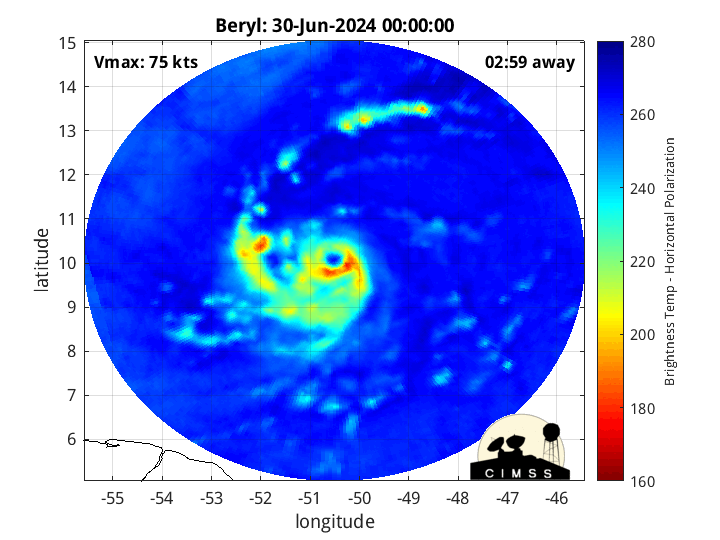
Morphed Integrated Microwave Imagery’s from CIMSS shows the rapid strengthening of Beryl over the weekend:

An aside: “Beryl” was an early season storm back in 2012 coming ashore in Duval Co. & metro Jacksonville, Florida just below hurricane strength during the weekend of Memorial Day.
:quality(70)/pbs.twimg.com/media/DeFjqSWW4AAIE7m.jpg)
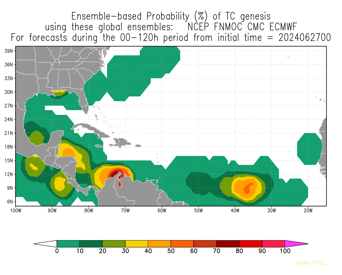
(2) Tropical wave - ‘94-L’ is moving over the Yucatan Peninsula. The wave will then briefly emerge over the Bay of Campeche (SW Gulf of Mexico) through early Monday at which point the wave will have a short window to try to organize & intensify. The 24 hours or so may be just enough for a tropical depression or low end tropical storm to form before reaching the Mexico coastline well south of Texas through the day Monday. No impacts to Jacksonville or any of Florida.
(3) Another tropical wave - ‘96-L’ - has just come off the coast of Africa with at good chance for development while moving west across the Atlantic over the upcoming week. This wave is following in the footsteps of Beryl for now but could take a track that’s at least a little more north of Beryl in the longer range. Long range global forecast models have been inconsistent, but it would *appear* conditions become less favorable the more west this wave gets, & it’s possible this wave (or possible t.d./t.s.) will struggle after the 4th of July. In any case... travelers & folks in the Caribbean, Gulf Coast & Southeast U.S. need to stay up to date on this system.
“Buresh Bottom Line”: Beryl impacts the Caribbean this week... Monday for the Central & Southern Lesser Antilles as a powerful hurricane... possibly Jamaica & the Caymen Islands later in the week followed by the Yucatan Peninsula.
The Western Caribbean wave - ‘94-L’ - will bring some heavy rain & gusty winds to the Yucatan & Mexico Gulf Coast into Monday. Time will tell as to whether or not the wave has enough time to organize & strengthen before landfall. Some enhancement of rain possible for far South Texas... no impacts on Florida.
The third wave - ‘96-L’ - may end up farther north than its two predecessors & will certainly need to be carefully monitored though environmental conditions appear marginal in the longer range.
Stay up to date on the latest forecasts....


REMEMBER WHEN A TROPICAL STORM OR HURRICANE IS APPROACHING: Taping windows is *not* recommended & will not keep glass from breaking. Instead close curtains & blinds.
Realize the forecast cone (”cone of uncertainty”) is the average forecast error over a given time - out to 5 days - & *does not* indicate the width of the storm &/or where damage might occur.


The upper oceanic heat content (UOHC) [tropical cyclone heat potential/TCHP] across the SW Atlantic, Gulf & Caribbean is unseasonably high for this time of year:


Water vapor loop (dark blue/yellow is dry mid & upper level air):


June tropical cyclone origins (early season breeding grounds are the Gulf &/or Western Caribbean:

Averages below based on climatology for the Atlantic Basin for November (7 hurricanes so far, 19 tropical storms):
Wind shear (red - strong shear; green - low shear):


Saharan dust spreads west each year from Africa driven by the prevailing winds (from east to west over the Atlantic). Dry air = yellow/orange/red/pink. Widespread dust is indicative of dry air that *can* interfere with the development of tropical cyclones. However, sometimes “wanna’ be” waves will just wait until they get to the other side of - or away from - the dust plume then try to develop if other conditions are favorable. In my personal opinion, there is way too much “hoopla” about the presence of Saharan dust & how it relates to tropical cyclones. In any case, the peak of Saharan dust typically is in June & July.

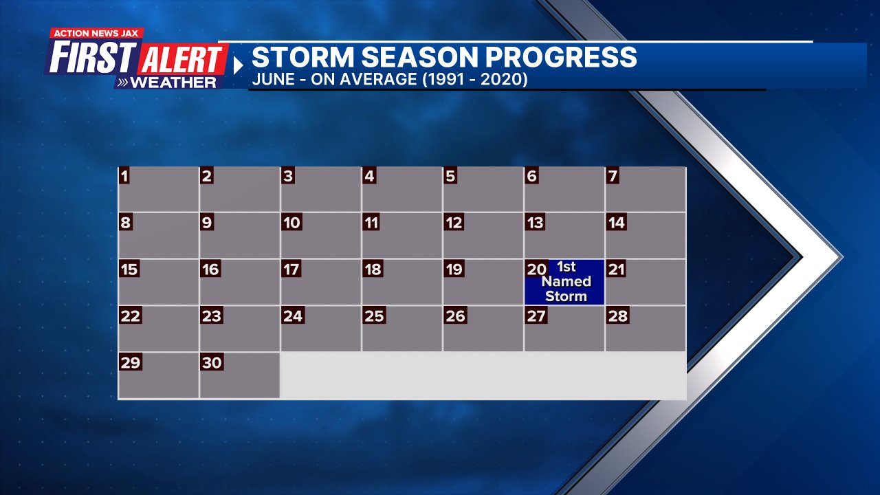
2024 names..... “Chris” is the next name on the Atlantic list (names are picked at random by the World Meteorological Organization... repeat every 6 years). Historic storms are retired [Florence & Michael in ’18 (the last time this year’s list was used)... Dorian in ’19 & Laura, Eta & Iota in ‘20, Ida in ‘21 & Fiona & Ian in ‘22]). In fact, this year’s list of names is rather infamous because of the ‘04 season when Charley, Frances, Jeanne & Ivan - all retired names - hit Florida within a matter of about 6 weeks. The WMO decided - beginning in 2021 - that the Greek alphabet will be no longer used & instead there will be a supplemental list of names if the first list is exhausted (has only happened three times - 2005, 2020 & 2021). The naming of tropical cyclones began on a consistent basis in 1953. More on the history of naming tropical cyclones * here *.


East Atlantic:


Mid & upper level wind shear (enemy of tropical cyclones) analysis (CIMMS). The red lines indicate strong shear:

Water vapor imagery (dark blue indicates dry air):

Deep oceanic heat content over the Gulf, Caribbean & deep tropical Atlantic. The colors will brighten greatly as the water warms to greater depths deeper into the season:

Sea surface temp. anomalies:


SE U.S. surface map:

Surface analysis centered on the tropical Atlantic:

Surface analysis of the Gulf:

Caribbean:

Atlantic Basin wave period forecast for 24, 48, 72 & 96 hours respectively:


East & Central Pacific:


West Pacific:

Global tropical activity:


Cox Media Group
:quality(70)/cloudfront-us-east-1.images.arcpublishing.com/cmg/KBQRCRUFOJAVPCINC4OQY7NFT4.jpeg)
:quality(70)/d1hfln2sfez66z.cloudfront.net/07-01-2024/t_df5b2680f5c94ee79fa5546752ce34b6_name_file_960x540_1200_v3_1_.jpg)
:quality(70)/d1hfln2sfez66z.cloudfront.net/07-01-2024/t_a2ee7bc6197f41fd96c899e675559981_name_file_960x540_1200_v3_1_.jpg)
:quality(70)/cloudfront-us-east-1.images.arcpublishing.com/cmg/L3W7RI6OT3B7DUI46VJL7Z3HH4.jpg)
:quality(70)/d1hfln2sfez66z.cloudfront.net/07-02-2024/t_678f9636d3b64c71a1217628f3ba4305_name_file_1920x1080_1200_v3_1_.jpg)