Jacksonville, Fl. — The “Buresh Bottom Line”: Always be prepared!.....First Alert Hurricane Preparation Guide... City of Jacksonville Preparedness Guide... Georgia Hurricane Guide.
STAY INFORMED: Get the * FREE * First Alert Weather app
FREE NEWS UPDATES, ALERTS: Action News Jax app for Apple | For Android
WATCH “Preparing for the Storm”
WATCH “The Ins & Outs of Hurricane Season”
READ the First Alert Hurricane Center “Preparation Guide”
***** ALWAYS CHECK & RE-CHECK THE LATEST FORECAST & UPDATES! *****
*** LOCAL (Jacksonville/NE Fl./SE Ga.) IMPACTS FROM THE TROPICS: None through at least Friday.
The Atlantic Basin Overview:
There continue to be indications of a more active period ahead beginning with a *potential* tropical system this weekend into early next week. But the uncertainty - always a consideration in the forecasting of anything but especially the weather! - is especially HIGH with this scenario.
(1) The European forecast model has generally recently trended west with a weak tropical system over or near Florida by Sunday into Monday while still turning northward then northeast. The GFS American model continues to be the west outlier (& poor run to run consistency) with a weak tropical wave crossing near or south of Florida this weekend then getting its act together over the Gulf of Mexico... the Canadian model is at least somewhat similar to the European with a weak wave into Florida followed by a northern turn with some intensification up the U.S. east coast or just offshore upon interaction with an upper level trough... the UKMET model is closer to the GFS taking a weak tropical system into the Eastern Gulf next week. Timing across the board does look to be over the weekend into early next week. And there is some chance that whatever tropical system might - or might not - develop is left behind by the next approaching trough. So a track simply “up & out” may not be realized.
The potential development is tied to a tropical wave - which has had a recent increase in t’storm activity albeit still very disorganized - that is approaching the Greater Antilles & SW Atlantic. The wave has been battling a thinning plume of Saharan dust & relatively dry air + a zone of at least moderate wind shear. Once out of the dust “cloud” & in an overall environment that appears more favorable - about Fri./Sat./Sun. (Aug. 2/3/4) - near the Fl. Straits or SW Atlantic, models then do their “thing” & in some way, shape or form trying to develop a tropical cyclone. Model solutions are jumping all over the place which is no surprise given the longer range not to mention there still isn’t even an actual surface feature. But this will be something to keep a close eye on for the Caribbean, Gulf & Western Atlantic. It is way too early to have any idea where at all how this scenario might - or might not - pan out despite we’re getting closer to “go time”. It is worth keeping in mind that the GFS was the more accurate global model on the last Atlantic tropical cyclone - “Beryl”.
Long term movement will largely be dictated by the sprawling Bermuda High & a persistent secondary upper level high (the infamous “heat dome”) that’s been camping out across the Central or Southern U.S. much of this summer. It’s also necessary to factor in when & if the potential system starts to strengthen. Earlier deepening would likely translate to an earlier turn northward (probably east of Florida) while a weaker, more shallow system would be steered by the prevailing winds & would likely get farther west (Gulf of Mexico). To muddy up things even more... there may be some land interaction with parts of the Greater Antilles.
*For the moment* it would appear an initially rather weak tropical system will be near Florida by Sunday perhaps into early next week.
The “Buresh Bottom Line”:
* the chance for a tropical system near Florida looks pretty high by the weekend/early next week.
* It would appear to be pretty weak at that time. Concerns would be centered around heavy rain, agitated seas & surf & a higher rip current risk.
* Florida is the “fork in the road” as to whether or not the track thereafter is more northward vs. more west.
* There is the potential for a stronger system in the *longer range*.
* Heads up for Florida & the U.S. east coast as well as the Gulf coast.
* Gusty rain & t’storm squalls will impact Puerto Rico & nearby islands through Thursday followed by the Bahamas Fri. into the weekend... & Florida later in the weekend/early next week.
In a broad sense... tropical development would generally fit the pattern with sprawling high pressure spread out at northern latitudes + a MJO impulse beginning to push eastward from the Pacific.
Keep in mind the NHC shading below is the area where development of a tropical system *might* occur & is NOT a forecast cone (as one would see when/if a tropical cyclone has actually developed)...


500mb - about 30,000 feet - Saturday (08/03) Euro forecast:

(2) A couple of active tropical wave are over the Central & Eastern Atlantic. Forecast models are not too excited about this wave, but it’s something to watch as the African “wave train” starts to ramp up & the MJO pulse spreads eastward.


The velocity potential anomalies map below shows a lot of sinking air (brown lines) - & a lack of convection - over the Atlantic Basin to the far East Pacific while rising air (green lines) is over the Central & West Pacific more convection is notable. Often the green areas (MJO pulse) will correlate with increased tropical activity. So it’s the W. Pacific that will be more active now but this pulse should move eastward - signs of which we’re already seeing - helping to set off a return to a more active Atlantic through at least the middle of August.
REMEMBER WHEN A TROPICAL STORM OR HURRICANE IS APPROACHING: Taping windows is *not* recommended & will not keep glass from breaking. Instead close curtains & blinds.
Realize the forecast cone (”cone of uncertainty”) is the average forecast error over a given time - out to 5 days - & *does not* indicate the width of the storm &/or where damage might occur.

The upper oceanic heat content (UOHC) [tropical cyclone heat potential/TCHP] across the SW Atlantic, Gulf & Caribbean is unseasonably high for this time of year:


Water vapor loop (dark blue/yellow is dry mid & upper level air):


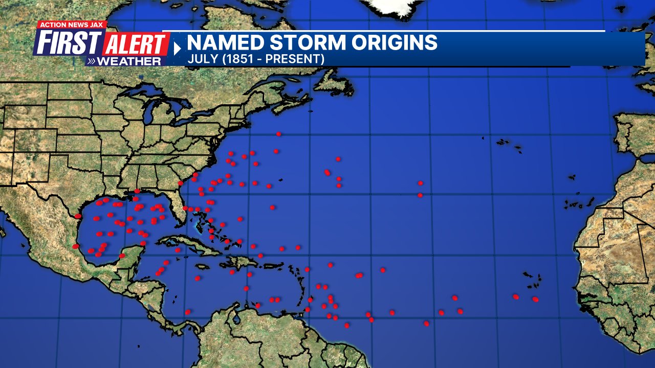
July tropical cyclone origins (early season breeding grounds are the Gulf &/or Western Caribbean:
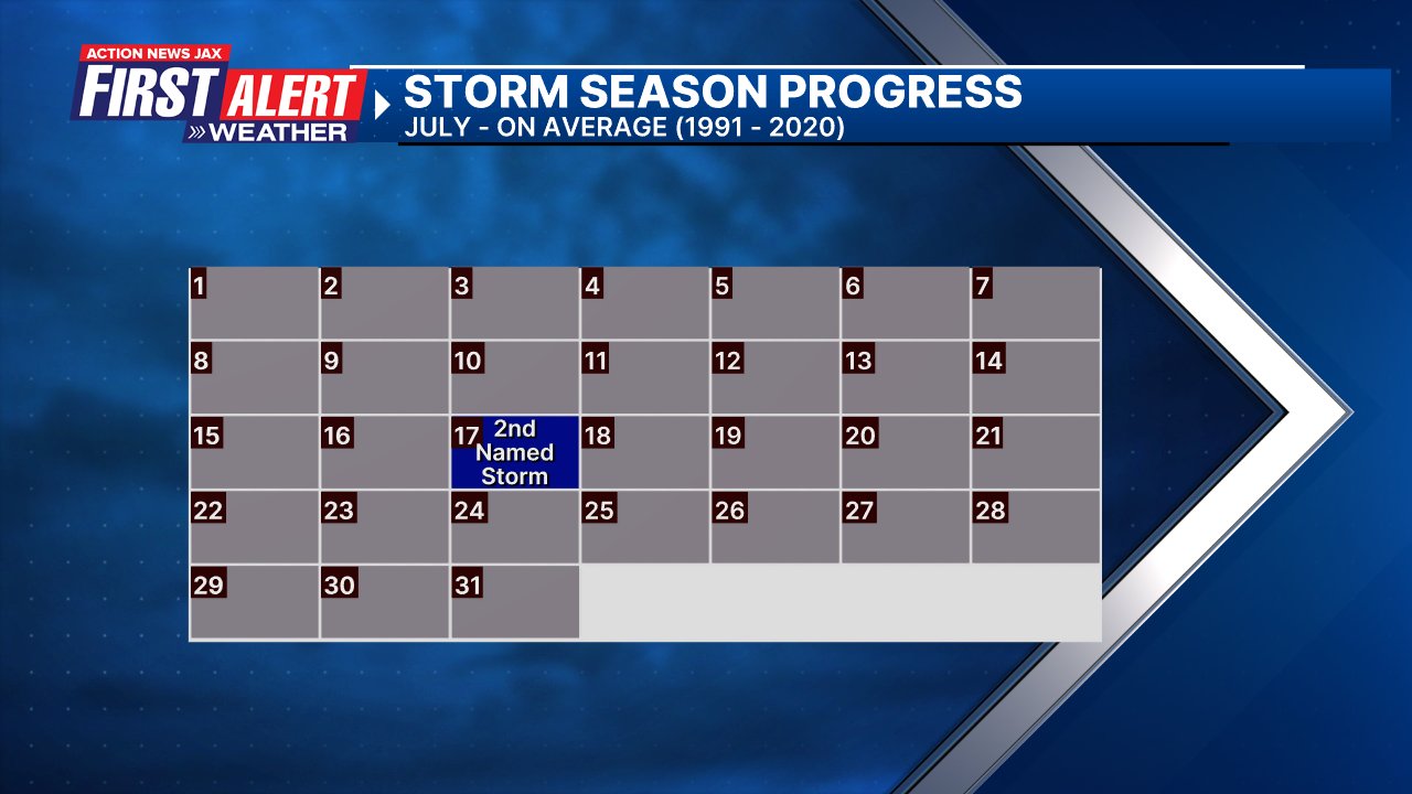
Averages below based on climatology for the Atlantic Basin for July (1 hurricane so far, 3 tropical storms):
Wind shear (red - strong shear; green - low shear):


Saharan dust spreads west each year from Africa driven by the prevailing winds (from east to west over the Atlantic). Dry air = yellow/orange/red/pink. Widespread dust is indicative of dry air that *can* interfere with the development of tropical cyclones. However, sometimes “wanna’ be” waves will just wait until they get to the other side of - or away from - the dust plume then try to develop if other conditions are favorable. In my personal opinion, there is way too much “hoopla” about the presence of Saharan dust & how it relates to tropical cyclones. In any case, the peak of Saharan dust typically is in June & July.

2024 names..... “Debby” is the next name on the Atlantic list (names are picked at random by the World Meteorological Organization... repeat every 6 years). Historic storms are retired [Florence & Michael in ’18 (the last time this year’s list was used)... Dorian in ’19 & Laura, Eta & Iota in ‘20, Ida in ‘21 & Fiona & Ian in ‘22]). In fact, this year’s list of names is rather infamous because of the ‘04 season when Charley, Frances, Jeanne & Ivan - all retired names - hit Florida within a matter of about 6 weeks. The WMO decided - beginning in 2021 - that the Greek alphabet will be no longer used & instead there will be a supplemental list of names if the first list is exhausted (has only happened three times - 2005, 2020 & 2021). The naming of tropical cyclones began on a consistent basis in 1953. More on the history of naming tropical cyclones * here *.


East Atlantic:


Mid & upper level wind shear (enemy of tropical cyclones) analysis (CIMMS). The red lines indicate strong shear:

Water vapor imagery (dark blue indicates dry air):

Deep oceanic heat content over the Gulf, Caribbean & deep tropical Atlantic. The colors will brighten greatly as the water warms to greater depths deeper into the season:

Sea surface temp. anomalies:


SE U.S. surface map:

Surface analysis centered on the tropical Atlantic:

Surface analysis of the Gulf:

Caribbean:

Atlantic Basin wave period forecast for 24, 48, 72 & 96 hours respectively:


East & Central Pacific:


West Pacific:

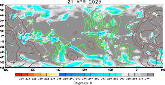
Global tropical activity:


Cox Media Group