
Jacksonville, Fl. — The “Buresh Bottom Line”: Always be prepared!.....First Alert Hurricane Preparation Guide... City of Jacksonville Preparedness Guide... Georgia Hurricane Guide.
STAY INFORMED: Get the * FREE * First Alert Weather app
FREE NEWS UPDATES, ALERTS: Action News Jax app for Apple | For Android
WATCH “Preparing for the Storm”
WATCH “The Ins & Outs of Hurricane Season”
READ the First Alert Hurricane Center “Preparation Guide”
***** ALWAYS CHECK & RE-CHECK THE LATEST FORECAST & UPDATES! ****
Tropics threats for Jacksonville/NE Florida/SE Georgia: None through the holiday weekend.
The Atlantic Basin Overview:
(1) Multiple tropical waves are moving rather sluggishly to the west between the Caribbean & coast of Africa with an indication of an uptick in their associated convection. One of the waves moving into the Central Atlantic has long term potential but inconsistency amongst the forecast models remains large... huge actually. After a seemingly more consistent signal of at least a developing tropical cyclone emerged Thursday for a time, just about each & every long range global model is seriously bouncing around on whether or not a tropical cyclone even develops ... to intensity ... to, of course, track. So there is not much definitive at this point.
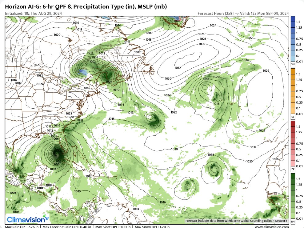
But - for right now - it appears a tropical wave will be nearing the Caribbean by the middle of next week within an environment reasonably favorable for strengthening. A new model the First Alert weather team has access to is the ClimaVision “Horizon” model which shows a hurricane near Florida in 8-10 days or roughly Sept. 8 - 11 & has been trending a little slower but at least has consistently shown a tropical cyclone developing (vs. storms appearing then disappearing as is the case with many of the traditional global models right now).
Dictating the steering will be the ol’ Bermuda High over the Central & Eastern Atlantic & upper level troughing over the Central/Eastern U.S. The positioning & strength of these two features will greatly impact the path of any possible long range tropical cyclone that may be over or near the Caribbean &/or SW Atlantic. And a slower to develop system (more shallow) would like get farther west.
(2) We’re also seeing mixed signals regarding a nearly stationary front from the Gulf to the Western Atlantic that gets reinforced by a series of upper level troughs & possible low pressure developing at the surface along the front. This could be some “in-close” development anywhere from the Gulf to the far Western Atlantic. Not much to truly latch onto yet but an area to watch.


The experimental Climavision ‘Horizon’ model for 8am Mon., Sept. 9th shows a hurricane over the Southeast Gulf of Mexico. While jumping around on position, the ‘Horizon’ has at least consistently shown development.
Anyone living in - or with travel plans to - the Caribbean should stay up to date on the latest forecasts. And it’s *possible* there could be eventual impacts on parts of the Gulf Coast, Florida/SE U.S. the week after next.

‘Velocity potential anomalies’ below shows massive “sinking” air (brown lines) continues across the Atlantic Basin. In such a state, tropical development can occur but overall conditions are not as conducive as when there is overall rising (green lines) air such as much of the Pacific Basin where tropical cyclones are active. This “pulse” of upward motion should move over the Atlantic Basin over the next few weeks.

REMEMBER WHEN A TROPICAL STORM OR HURRICANE IS APPROACHING: Taping windows is *not* recommended & will not keep glass from breaking. Instead close curtains & blinds.
Realize the forecast cone (”cone of uncertainty”) is the average forecast error over a given time - out to 5 days - & *does not* indicate the width of the storm &/or where damage might occur.

The upper oceanic heat content (UOHC) [tropical cyclone heat potential/TCHP] across the SW Atlantic, Gulf & Caribbean is unseasonably high for this time of year:


Water vapor loop (dark blue/yellow is dry mid & upper level air):


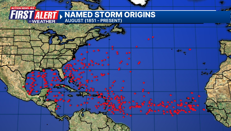
August tropical cyclone origins (early season breeding grounds are the Gulf &/or Western Caribbean:
Averages below based on climatology for the Atlantic Basin for August (1 hurricane so far, 3 tropical storms):

Wind shear (red - strong shear; green - low shear):


Saharan dust spreads west each year from Africa driven by the prevailing winds (from east to west over the Atlantic). Dry air = yellow/orange/red/pink. Widespread dust is indicative of dry air that *can* interfere with the development of tropical cyclones. However, sometimes “wanna’ be” waves will just wait until they get to the other side of - or away from - the dust plume then try to develop if other conditions are favorable (we’ve already seen this with Beryl & Debby this year). In my personal opinion, there is way too much “hoopla” about the presence of Saharan dust & how it relates to tropical cyclones. In any case, the peak of Saharan dust typically is in June & July.

2024 names..... “Francine” is the next name on the Atlantic list (names are picked at random by the World Meteorological Organization... repeat every 6 years). Historic storms are retired [Florence & Michael in ’18 (the last time this year’s list was used)... Dorian in ’19 & Laura, Eta & Iota in ‘20, Ida in ‘21 & Fiona & Ian in ‘22]). In fact, this year’s list of names is rather infamous because of the ‘04 season when Charley, Frances, Jeanne & Ivan - all retired names - hit Florida within a matter of about 6 weeks. The WMO decided - beginning in 2021 - that the Greek alphabet will be no longer used & instead there will be a supplemental list of names if the first list is exhausted (has only happened three times - 2005, 2020 & 2021). The naming of tropical cyclones began on a consistent basis in 1953. More on the history of naming tropical cyclones * here *.


East Atlantic:


Mid & upper level wind shear (enemy of tropical cyclones) analysis (CIMMS). The red lines indicate strong shear:

Water vapor imagery (dark blue indicates dry air):

Deep oceanic heat content over the Gulf, Caribbean & deep tropical Atlantic. The colors will brighten greatly as the water warms to greater depths deeper into the season:

Sea surface temp. anomalies:


SE U.S. surface map:

Surface analysis centered on the tropical Atlantic:

Surface analysis of the Gulf:

Caribbean:

Atlantic Basin wave period forecast for 24, 48, 72 & 96 hours respectively:


East & Central Pacific:
“Hone” became a hurricane Sat. night with its closest approach to the Big Island of Hawaii through the day Sunday producing some squalls & localized flooding but - in the end - not a major hit on the islands. Hone is turning more northwest & will eventually cross the dateline into the West Pacific where conditions may become more favorable again:


Hawaii satellite imagery:


West Pacific:

Global tropical activity:


“Shanshan” is weakening over Japan:


Cox Media Group


