:quality(70)/cloudfront-us-east-1.images.arcpublishing.com/cmg/JIFG55NSN5HKZK6LKEZ4C7UU5I.jpg)
Jacksonville, Fl. — The “Buresh Bottom Line”: Always be prepared!.....First Alert Hurricane Preparation Guide... City of Jacksonville Preparedness Guide... Georgia Hurricane Guide.
STAY INFORMED: Get the * FREE * First Alert Weather app
FREE NEWS UPDATES, ALERTS: Action News Jax app for Apple | For Android
WATCH “Preparing for the Storm”
WATCH “The Ins & Outs of Hurricane Season”
READ the First Alert Hurricane Center “Preparation Guide”
***** ALWAYS CHECK & RE-CHECK THE LATEST FORECAST & UPDATES! *****
*** LOCAL (Jacksonville/NE Fl./SE Ga.) IMPACTS FROM THE TROPICS: A bit of an uptick in showers & t’storms Fri./Sat. as a trough of low pressure moves northward offshore.
The Atlantic Basin Overview:
(1) A surface trough of low pressure that began with an upper level low has developed east of Florida & is producing very disorganized but quite persistent showers & t’storms. This system will move slowly north & north/northwest through the weekend. Conditions look marginal for any tropical development, but there may be some attempt at a more consolidated low pressure area as the system approaches the Carolina’s by the weekend.


Radar imagery courtesy South Florida Water Management District:

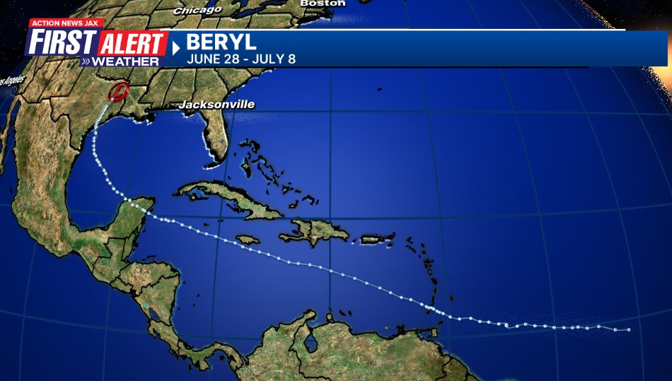
(2) The strong tropical wave - ‘95-L’ - that moved off the coast of Africa June 25 took just 13 days to move across the Atlantic, Caribbean & Gulf of Mexico before a U.S. landfall. The wave was upgraded to tropical depression #2 Friday afternoon, June 28 ... tropical storm Beryl Friday evening... & the first hurricane of the Atlantic season Sat. afternoon, June 29 becoming a ‘major’ Cat. 3 early Sunday, July 1 then a Cat. 5 late Mon. evening, July 2nd. Beryl’s second landfall (1st in Windward Islands) was just northeast of Tulum, Mexico on the Yucatan Peninsula about 7am EDT Fri. as a Cat. 2... & slowly reorganized becoming a hurricane again near midnight Sunday before a Cat. 1 landfall near 4am Monday at Matagorda, Texas or 85 miles south/southwest of Houston. Beryl was downgraded to a tropical depression over Eastern Texas late Monday & the last NHC advisory was issued at 11pm Monday.
Beryl has been shattering the early season record books... from Dr. Phil Klotzbach:
Intensity Measures
- 165 mph (Category 5) lifetime maximum sustained winds – strongest maximum sustained winds for an Atlantic hurricane prior to August on record. Old record (Emily, 2005 – 160 mph – also a Category 5).
- 934 hPa lifetime minimum central pressure – 3rd lowest central pressure for an Atlantic hurricane prior to August on record. Trailing (Emily, 2005 – 929 hPa and Dennis, 2005 – 930 hPa). - Earliest Atlantic Category 4 hurricane on record (30 June at 18 UTC). Old record was Dennis (8 July 2005 at 0 UTC).
- Earliest Atlantic Category 5 hurricane on record (2 July at 3 UTC). Old record was Emily (17 July 2005 at 0 UTC).
- Beryl became a hurricane at 49.3°W – the farthest east an Atlantic hurricane had formed in the tropics (south of 23.5°N) in June on record. Old record was Cuba/Brownsville of 1933 (59°W).
- 65 mph/24 hr intensification rate from 29 June – 30 June – the fastest 24 hr intensification rate for an Atlantic named storm this early in the calendar year on record. Previous earliest 65 mph/24 hr intensification rate was Bertha (2008) from 6 July – 7 July.
- ~35 Accumulated Cyclone Energy (ACE) – the most ACE by a single Atlantic storm getting named prior to 1 August on record. Old record was Emily (2005 – ~33 ACE).
- 4.5 major (Category 3+) hurricane days – the most for a storm getting named prior to 1 August on record. Old record was Emily (2005 – 4.25 major hurricane days).
- 9.75 named storm days – 6th most for a storm getting named prior to 1 August on record.
- 6.25 hurricane days – 7th most for a storm getting named prior to 1 August on record.
Landfalls - Carriacou Island, Grenada: 150 mph, 950 hPa – Category 4 (1 July, 1510 UTC) - Strongest hurricane on record to make landfall in Grenada. Hurricane Ivan (2004) did not officially make landfall on Grenada but passed ~10 miles south of the main island of Grenada with maximum winds estimated at 125 mph, damaging 90% of the homes on the island
- Quintana Roo, Mexico: 110 mph, 975 hPa – Category 2 (5 July, 1105 UTC) - First Category 2+ hurricane to make landfall in Quintana Roo in July since Emily (2005) (Category 4, 130 mph)
- Matagorda, Texas: 80 mph, 979 hPa – Category 1 (8 July, 9 UTC) - Earliest calendar year hurricane landfall in Texas since Bonnie (26 June 1986) - 10th hurricane to make landfall in Texas in July on record and the first since Hanna (2020
Beryl exited the Yucatan Peninsula late Friday - as a tropical storm moving over the Western Gulf of Mexico while turning more northward trying to ward off dry air & shear. Beryl lost much of its core, so it took a while to reorganize & had a broad 28 mile wide eye at landfall.
The remnant low pressure system has merged with a frontal boundary while moving northeast reaching the Great Lake & then SE Canada through Wed. night still producing heavy rain & isolated tornadoes.


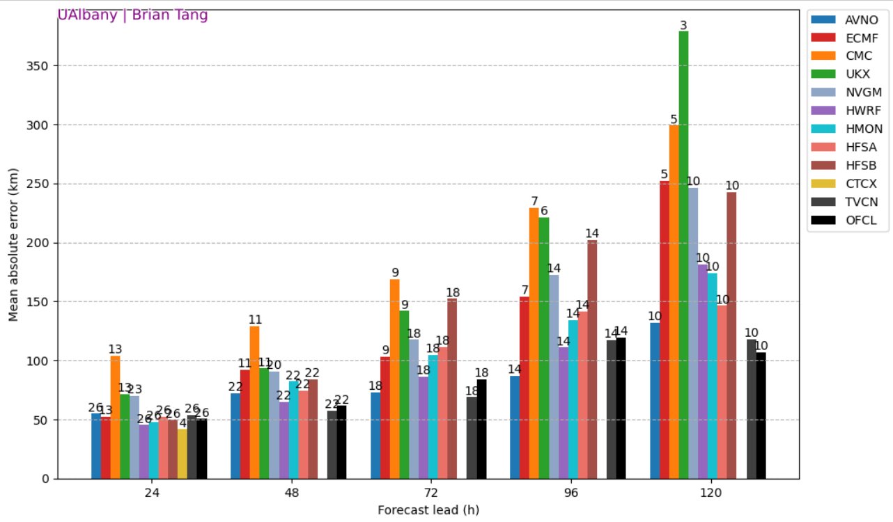
The GFS (American) model has been best on “Beryl”... the NHC has consistently beaten all the modeling(!):
REMEMBER WHEN A TROPICAL STORM OR HURRICANE IS APPROACHING: Taping windows is *not* recommended & will not keep glass from breaking. Instead close curtains & blinds.
Realize the forecast cone (”cone of uncertainty”) is the average forecast error over a given time - out to 5 days - & *does not* indicate the width of the storm &/or where damage might occur.

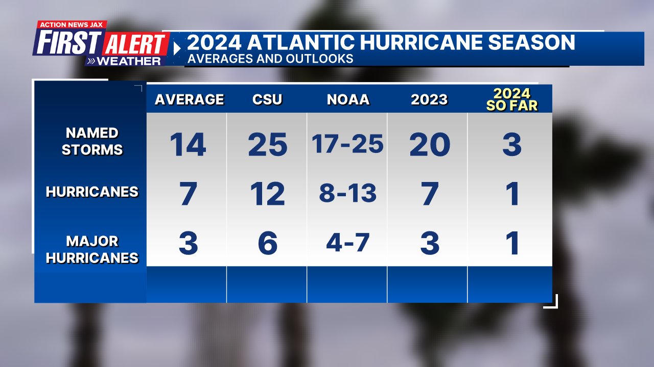
Updated (July 9th) seasonal forecast from Dr. Phil Klotzbach, Colorado State University:

The upper oceanic heat content (UOHC) [tropical cyclone heat potential/TCHP] across the SW Atlantic, Gulf & Caribbean is unseasonably high for this time of year:


Water vapor loop (dark blue/yellow is dry mid & upper level air):


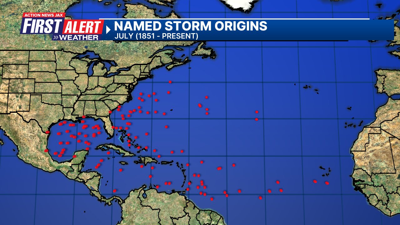
July tropical cyclone origins (early season breeding grounds are the Gulf &/or Western Caribbean:
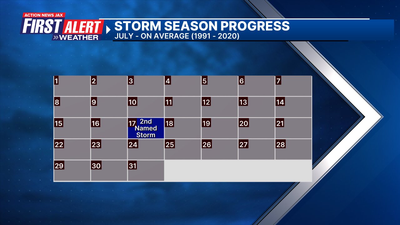
Averages below based on climatology for the Atlantic Basin for July (1 hurricane so far, 3 tropical storms):
Wind shear (red - strong shear; green - low shear):


Saharan dust spreads west each year from Africa driven by the prevailing winds (from east to west over the Atlantic). Dry air = yellow/orange/red/pink. Widespread dust is indicative of dry air that *can* interfere with the development of tropical cyclones. However, sometimes “wanna’ be” waves will just wait until they get to the other side of - or away from - the dust plume then try to develop if other conditions are favorable. In my personal opinion, there is way too much “hoopla” about the presence of Saharan dust & how it relates to tropical cyclones. In any case, the peak of Saharan dust typically is in June & July.

2024 names..... “Debby” is the next name on the Atlantic list (names are picked at random by the World Meteorological Organization... repeat every 6 years). Historic storms are retired [Florence & Michael in ’18 (the last time this year’s list was used)... Dorian in ’19 & Laura, Eta & Iota in ‘20, Ida in ‘21 & Fiona & Ian in ‘22]). In fact, this year’s list of names is rather infamous because of the ‘04 season when Charley, Frances, Jeanne & Ivan - all retired names - hit Florida within a matter of about 6 weeks. The WMO decided - beginning in 2021 - that the Greek alphabet will be no longer used & instead there will be a supplemental list of names if the first list is exhausted (has only happened three times - 2005, 2020 & 2021). The naming of tropical cyclones began on a consistent basis in 1953. More on the history of naming tropical cyclones * here *.


East Atlantic:


Mid & upper level wind shear (enemy of tropical cyclones) analysis (CIMMS). The red lines indicate strong shear:

Water vapor imagery (dark blue indicates dry air):

Deep oceanic heat content over the Gulf, Caribbean & deep tropical Atlantic. The colors will brighten greatly as the water warms to greater depths deeper into the season:

Sea surface temp. anomalies:


SE U.S. surface map:

Surface analysis centered on the tropical Atlantic:

Surface analysis of the Gulf:

Caribbean:

Atlantic Basin wave period forecast for 24, 48, 72 & 96 hours respectively:


East & Central Pacific:
A tropical storm - Aleta - finally developed over the E. Pacific July 4th - the latest on record (of the satellite era). The storm lasted little more than 24 hours & has dissipated.


West Pacific:

Global tropical activity:


Cox Media Group
:quality(70)/cloudfront-us-east-1.images.arcpublishing.com/cmg/2F2LTUISQFDMJG57HEGXVHDFRI.jpg)
:quality(70)/d1hfln2sfez66z.cloudfront.net/07-30-2024/t_f3f84ee37c38427ab0b290aedbd22848_name_file_960x540_1200_v3_1_.jpg)
:quality(70)/d1hfln2sfez66z.cloudfront.net/07-31-2024/t_c73bb2e5b61a4e329cbdf691d09906e7_name_file_960x540_1200_v3_1_.jpg)
:quality(70)/d1hfln2sfez66z.cloudfront.net/07-10-2024/t_e8966e85c6c84b9793e4777cb5017b1d_name_file_960x540_1200_v3_1_.jpg)
:quality(70)/cloudfront-us-east-1.images.arcpublishing.com/cmg/GUKNEPXKO4TU3TGUXRFOFQBQLY.jpg)